Emergency officials finished preparations for rising waters along the White River by evacuating more residents and placing sandbags around businesses, and residents in Pocahontas for the first time Sunday were able to see damage done to their homes by the flooded Black River.
U.S. Agriculture Secretary Sonny Perdue, who took office in April, flew over the flooding in northeast Arkansas, saying at a Sunday afternoon news conference in an aircraft hangar in Little Rock that he was committed to expediting a declaration of damage as quickly as possible.
"I want your farmers of Arkansas to know that the resources of the U.S. Department of Agriculture will be at their disposal," Perdue said, mentioning that officials with the Farm Service Agency and the Natural Resources Conservation Service are already in the state.
Perdue, along with Gov. Asa Hutchinson, Sen. John Boozman, and Reps. French Hill and Rick Crawford, toured Des Arc, Pocahontas, Portia and Success -- a small Clay County community that flooded when the Current River rose.
Perdue said President Donald Trump asked him to go to Arkansas to take a close look at the effect the flooding has had on the state's agriculture, including rice and soybean crops.
"There's no substitute for seeing it, from being here on the ground or, specifically, in the air," he said.
At least nine people died when storms ripped through the state on April 29 and 30, dumping 4 to 6 inches of rain on much of an already rain-soaked northern Arkansas. The rain caused flash flooding in Northwest Arkansas, and storms knocked out power to more than 80,000 people.
The storm system also deluged southern Missouri with up to 10 inches of rain, which engorged the Current River. Van Buren, Mo., and Doniphan, Mo., saw recorded rises on the Current River, and the wave of water flowed south into Arkansas and the Black River.
Hutchinson issued disaster declarations for 36 Arkansas counties and said he expects to soon seek a federal declaration for the state.
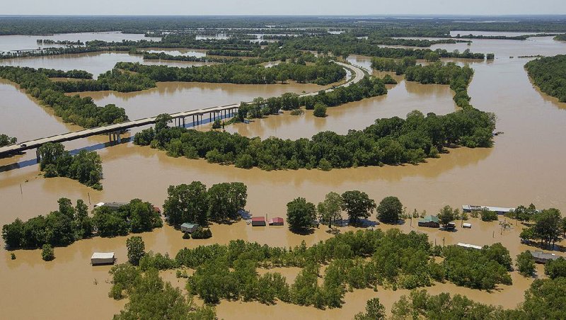
On Tuesday, the Black River rose to 28.95 feet in Pocahontas, breaking the previous high mark of 28.4 feet set on April 28, 2011. Nine sections of the Running Water Ditch, which runs along the southern edge of the Black River, broke, sending water rushing into an east Pocahontas residential area and south toward Portia in Lawrence County.
The water has since receded on the Black River, but the "flood wave," or a surge of water moving down the river, entered the White River at the Black River's confluence at Jacksonport, and officials are now preparing for high waters in the Delta.
The White River rose about a foot and a half in 24 hours in Des Arc, said Davis Bell, a spokesman for the Prairie County Office of Emergency Management. The river was at 34.28 feet Sunday afternoon, with the National Weather Service forecasting it to crest at 36.5 feet Wednesday morning. Flood stage in Des Arc is 24 feet.
"It's been steady," Bell said. "But it's slow."
National Guardsmen were dispatched to the Prairie County town for security to prevent anyone from looting homes that are evacuated because of the rising river.
Workers also built a 5-foot-tall levee on the western banks of the city of 1,933 to protect low-lying areas. More flooding was expected east of the town in the Spring Lake community.
"We evacuated most of the people who need to be out," Bell said.
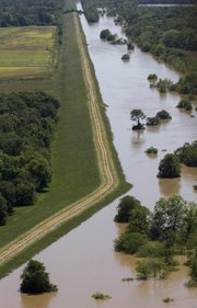
Arkansas Game and Fish personnel surveyed the permanent White River levee -- both on four-wheelers and by boat -- to ensure there were no cracks or leaks.
"You've got to wonder about the integrity of the levee," Bell said. "We'll have four, eight, 10 days of high water. Can the levee withstand that much?"
The river will be slow to recede. After cresting on Wednesday, the weather service said, the river will remain within 6 inches of that high mark through at least May 17.
"There is a lot of water over the river's banks," said meteorologist Michael Brown of the National Weather Service in North Little Rock. "The White River is a slow-moving river, and it is full."
The White River flows into the A̶r̶k̶a̶n̶s̶a̶s̶ ̶R̶i̶v̶e̶r̶ Mississippi River, and the flood wave will eventually pour into the Arkansas River*, Brown said.
However, the rising Mississippi River will slow the White River's recession, he said.
The Mississippi River at Osceola was at 33.7 feet Sunday evening and is expected to reach 36.5 feet on Friday. Flood stage there is 28 feet. It will take another week before the river recedes to below minor flood stage.
In Arkansas City, downstream from where the White flows into the Arkansas River, the Mississippi climbed to 35.6 feet Sunday evening and will slowly climb to its crest, forecast to reach 39.5 feet on May 16.
"When the Mississippi River is high, everything drains slower," Brown said.
He compared the river systems to a table. If the table is tilted, things will roll off quickly, just as water from the Black, White and Arkansas rivers will pour quickly into the Mississippi. If the table is level, items on it are slower to roll; by comparison, rivers are slower to drain and recede.
In Pocahontas, the Black River continued dropping, reaching 24.3 feet Sunday evening. Arkansas 328 opened Sunday afternoon after highway officials closed it in the morning when the Current River rose briefly. U.S. 67 between Pocahontas and Walnut Ridge remained closed Sunday, but David Jansen, county judge in Randolph County, said water was dropping quickly and that he expected the road to open soon.
Mary Haynes was able to return to her Douglas Street home in east Pocahontas Sunday to see how much water flooded her house.
"I got 2 or 3 feet up on the walls," she said of the water's height at its peak.
"I'm going to have to take out the walls and floors if I can get some help."
It's the second time her home has flooded. When sections of the Running Water Ditch broke in 2011, water poured into the home.
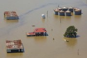
Jansen said at least 50 homes were destroyed by the water this time and that another 100 were damaged.
"This has gone from a rescue operation to recovery," Jansen said. "This is going to take quite a while. Hopefully, tomorrow we'll get a little more done."
He urged residents who are returning to their flood-ravaged homes to watch out for snakes and other animals that have been displaced by the rising waters.
Haynes said she saw a large snake on the front porch of her home and heard that some neighbors found snakes inside their homes.
Jansen, like many county judges and emergency management officials, said he has not been able to tally damage estimates in his county because so much is still underwater.
"We've got culverts and roads out all over," he said. "We just can't see them yet because the water is still up."
Officials should have a clearer idea of the amount of damage later this week, said Melody Daniel, a spokesman for the Arkansas Department of Emergency Management. She said officials with the Federal Emergency Management Agency are expected to begin surveying damage in the state by Wednesday.
Perdue said Sunday during his news conference that he hopes the state will receive federal aid quickly. Damage assessments will be provided to Hutchinson's office before being sent to the U.S. Department of Agriculture, he said.
Perdue said farmers are resilient people and will recover from the flooding,
"From a farmer's perspective, I've been there," said Perdue, who was raised in a farm family in Georgia.
"I know the thrill of a wonderful crop and the despair of flooding and drought."
Forecasters say Arkansas will see clear skies through Wednesday before showers move into the state Thursday and Friday.
Brown said there won't be enough rain to cause any more flooding issues.
"It will slow the river's fall," he said of the White River. "But it's not enough to make it go back up again."
A Section on 05/08/2017
*CORRECTION: The White River empties into the Mississippi River in southeastern Arkansas. The last 10 miles of the river serves as the final segment of the McClellan-Kerr Arkansas River Navigation System. The Arkansas River meets the Mississippi River about 8 miles south of the confluence of the White and Mississippi rivers. A previous version of this article incorrectly stated the White River’s path.