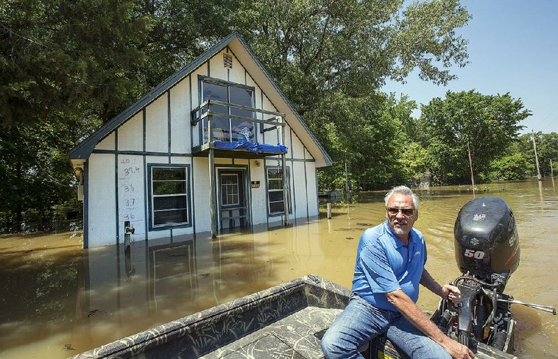
POCAHONTAS -- Denny Riney stood next to a pile of waterlogged debris at his Douglas Street home in east Pocahontas on Monday and considered moving.
Last week's floodwaters from the rising Black River soaked the floors of his home of 39 years and reached about a foot up the walls. Riney said he will have to pull out his carpeting and replace wallboard 4 feet up throughout his house.
"It's devastating," he said. "I want to move, but I've got this home paid for."
It's the second time this decade that he and others in the neighborhood of about 150 homes have been flooded by the river. His home and others in the neighborhood also were damaged by flooding in 2011, when a levee broke in three spots.
When 10 inches of rain fell in southern Missouri on April 29 and 30, water rushed into the Current River and downstream to the Black River between Pocahontas and Corning. The Black River reached a record high of 28.95 feet May 2, topping its previous high mark of 28.4 feet set in April 2011.
Other storms dumped 6 to 8 inches across much of Arkansas on April 29 and 30, causing flash floods, knocking out power to more than 80,000 and damaging roads. At least nine people died in the storms.
The Running Water Ditch levee, an 8-mile-long stretch of earthen levee that runs on the southern edge of the Black River, broke in nine places after water overtopped it, sending up to 4 feet of water, silt, debris and muck into some of the homes in Riney's neighborhood.
On Sunday, authorities let residents return to their homes. Piles of soaked insulation, carpeting, mattresses, drywall, appliances and furniture lay in front of scores of houses along Douglas, Scott and Vicki streets and Tara Drive on Monday.
Police patrolled the streets and kept watch for any looting while backhoe scooped the debris on trucks to begin the cleanup process.
Mathew Book said he expects it will take three months to get his mother-in-law's Douglas Street home ready for her to move back in.
"We've got water under the house," he said. "I'll have to take the drywall out and clean up all the mold."
Although the water had receded, the neighborhood smelled of mud and decay.
Book said he found a large snake basking in the sun on his mother-in-law's porch Sunday. Others reported seeing turtles, mice, rats, moles, rabbits, deer and snakes in their yards and inside their homes.
"It's pretty much a loss," said one man who would not give his name. "All our appliances are gone. You get bit once in 2011 and you try again, but then the second time comes around. Who knows if we'll come back."
Mike Cooper left his home on April 30 as a precaution.
"I didn't think anything would happen," he said. "I didn't figure the levee would break.
"When I heard about it, I came back expecting to see the worst, but I was still stunned."
Ted Garrett was one of a handful of residents who refused to leave when police began evacuating the neighborhood May 1. Garrett's father, Lonnie Garrett, did leave, staying in a Pocahontas shelter because he feared power could be knocked out and he is on oxygen.
Water did not reach the Garretts' Pace Street home.
"I sat on the porch and watched the river rise," Ted Garrett said. "It got up to the other side of the road and then went west."
Garrett's neighbor measured about 4 inches of water inside his home.
The Black River crested May 2 and continues to recede.
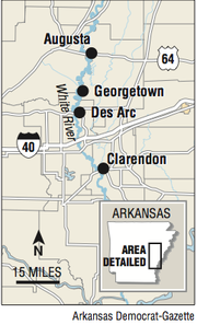
However, the glut of water, or the "flood wave," has made its way from the Black River into the White River. Officials in Des Arc, Clarendon, Georgetown and DeValls Bluff are preparing for crests this week.
In Des Arc, the White River measured 35.3 feet Monday evening. The National Weather Service in North Little Rock forecasts the river to crest at 36 feet early Wednesday morning.
The crest is 6 inches below what forecasters originally predicted, said Davis Bell, spokesman for the Prairie County Office of Emergency Management.
That half-foot drop means several homes, including one owned by Des Arc Police Chief Rick Parson, will probably be spared from flooding, Davis said.
"Each day we meet to discuss flood preparations and we have a prayer at the end," Davis said. "When we heard about the drop in the forecast [Monday] I said, 'Those prayers are working.' We are really excited about the news."
City workers built a 5-foot-high earthen levee along Main Street to protect lowlying areas of town from encroaching water, and officials with the Arkansas Game and Fish Commission continued patrolling levees along the river to monitor their integrity.
Prairie County Deputy Treasurer Brittney Kocourek said she has watched the river rise from her courthouse window daily.
"It's 20 steps from the courthouse today," she said Monday afternoon. "The streets by the river are covered up. People are boating in and tying their boats to road signs."
She said she gives daily updates to family members who don't live in the area.
"Each day I use gauges to see how high the water has gotten," Kocourek said. "Every time I look at that gauge the next day, it's under water."
The National Weather Service said the White River will crest in Clarendon in Monroe County early Sunday morning at 35.5 feet. Flood stage there is 26 feet.
The White River crested Monday morning at Georgetown and is expected to begin slowly receding late this evening.
A Section on 05/09/2017