5:50 P.M. UPDATE:
Meteorologists said Thursday afternoon that their confidence “continues to increase” that a strong storm system will bring precipitation, including snow, to Arkansas this weekend. At least one event was affected by the potential for inclement weather.
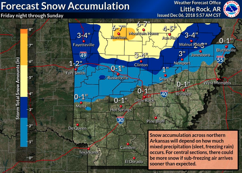
The National Weather Service in North Little Rock expects “several inches of snow” in the north-central part of the state, while other areas may see freezing rain and and up to a quarter of an inch of ice.
On Friday, rain is expected statewide, the agency said. As colder air arrives, the “changeover to winter precipitation” will start across the north late Friday and early Saturday. The colder air will move south Saturday, bringing with it winter precipitation. The storm system will move east early Sunday.
South Arkansas could see more than 5 inches of rain and water on roads will likely freeze, the weather service said.
Arkansas State University in Jonesboro announced Thursday afternoon that its Saturday commencement ceremony would be delayed until noon. The event was originally scheduled to begin at 10 a.m.
Read Friday's Arkansas Democrat-Gazette for full details.
— Maggie McNeary
EARLIER:
A winter storm watch has been issued by the National Weather Service for much of northern Arkansas in a wintry blast that could span multiple days, meteorologists said.
The weather service said on Thursday that the watch will begin late Friday and last through early Sunday. The storm could bring 4 to 6 inches of snow along with significant ice accumulation across portions of northern Arkansas.
Sean Clarke, a meteorologist in the agency's North Little Rock office, said the bulk of the storm will likely hit Saturday morning.
Travel impacts are expected and power outages are possible, the weather service said in a statement.
Clarke said there is also a chance the wintry weather could also impact central Arkansas, although that region is not included in the watch area.
“[Central Arkansas] won't receive near the amount that northern Arkansas is facing,” Clarke said. “Worst-case scenario, the central Arkansas area could get two to three inches, but officially we aren't predicting more than an inch.”
Minor snow, sleet, and ice accumulations are possible in the central region, generally along and north of the Interstate 30/Interstate 40 corridor, the weather service said.
The storm's path can be hard to predict because it hasn't even made landfall yet.
“We use upper air ballon launches to track weather patterns,” Clarke said. “It should hit the coast of California sometime in the next 12 to 24 hours and then the balloons will actually sample the storm and we will have a better gauge at what we are looking at.”
The weather service said much of the forecast hinges on how quickly cold air moves in from the northeast.
If cold air moves in more quickly than forecasted, snow and ice accumulations will increase and there will be more widespread winter weather in central Arkansas. If cold air moves in slowly, the total accumulations will be less significant.
The storm will also bring along the possibility of several inches of rain across southern Arkansas as well. While widespread flooding is not expected, localized flooding will be possible.
— Stephen Simpson