3 p.m. UPDATE
National Weather Service meteorologists announced winter weather advisories for Monday affecting portions of north central and Northwest Arkansas.
The agency said that Benton, Carroll, Madison and Washington counties are under a winter weather advisory from 3 a.m. to 6 p.m. In Baxter, Boone, Fulton, Marion, Newton and Searcy counties, a winter weather advisory is in effect from 6 a.m. to 6 p.m.
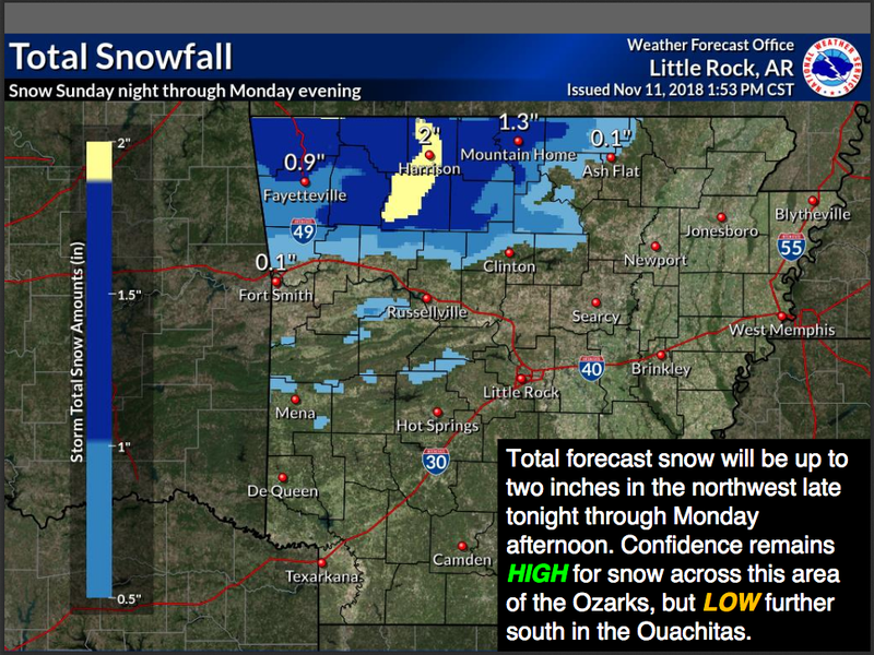
Total accumulations from sleet and snow are now expected to be between 1 to 2 inches, though up to 3 inches is possible in higher terrain, forecasters said.
Forecasters urged drivers to be prepared for slippery road conditions and reduced visibility, to use caution while driving, and to check road conditions, which can be found on the Arkansas Department of Transportation's Idrivearkansas website.
EARLIER:
National Weather Service meteorologists say they are increasingly confident that part of the state will see accumulating snowfall Sunday night into Monday.
The agency in North Little Rock said in a statement that a system will start as rain and then transition to snow for a time, especially in Northwest Arkansas. Parts of that region could see up to about an inch of snow, and higher terrains may see more, forecasters said.
Light snowfall "may extend farther southeast towards central Arkansas," the weather service said, though no accumulation is expected there.
"Ground temperatures remain well above freezing, so minimal impacts are expected from the snowfall at this time," the agency wrote.
Below freezing temperatures are expected across most of the state on Tuesday morning, and on Wednesday morning, temperatures in the teens and 20s are forecast.