As is often the case when I pull into Texarkana early in the evening, Cattleman's Steak House on the Arkansas side of State Line Avenue is my first stop.
When Roy Oliver opened the restaurant more than 50 years ago, State Line was a two-lane road. His business was surrounded by woods. The road is much wider now, and the woods are gone. But this place is like stepping back in time.
Cattleman's looks like a steak house should with its wood paneling, green chairs and red carpet. As far as I know, it's the only restaurant in the state where you can order calf fries and turkey fries as an appetizer. If you have to ask what they are, don't bother ordering them.
The goal is to spend a couple of days exploring west Arkansas along U.S. 71 between Texarkana and Mena. It's a part of the state that residents in other regions of Arkansas know little about.

I grew up about halfway between Little Rock and Texarkana. We usually went to Little Rock when we wanted to visit the "big city," but my parents occasionally took me to Texarkana as a change of pace. Downtown Texarkana was hopping in those days. Lunch was always at Bryce's Cafeteria.
To say that downtown has changed since then is an understatement. I love to find places that are serious about revitalizing their downtowns, but the kindest way to put it here on the border is that Texarkana has a long way to go.

There's potential, mind you--Union Station, the former Grim Hotel and additional old buildings. Union Station was built in 1928-29 by the Union Station Trust, a joint effort of the Missouri Pacific, Cotton Belt, Kansas City Southern and Texas & Pacific railroads.
E.M. Tucker, the chief Missouri Pacific architect, used the same style he had utilized in rebuilding the Little Rock depot following a 1921 fire. A dedication ceremony was held at Texarkana on May 12, 1930. The building straddles the state line with entrances and exits in both states. The station, which needs a lot of work, has been on the National Register of Historic Places since 1978.
Another downtown landmark is the U.S. Post Office and Federal Building, which also straddles the state line. It was built in 1933 and features Texas pink granite and Arkansas limestone. It's a tradition for those visiting Texarkana to have their photos taken in front of the building with one foot in Texas and the other foot in Arkansas.
Breakfast the next morning is at Johnny B's downtown. I buy a copy of the Texarkana Gazette and am greeted by a headline that proclaims: "Hotel Grim developer expects a spring start: Sale expected to close in February."
For years, the Hotel Grim (one of my favorite business names; it's right up there with the former Gross Mortuary at Hot Springs) housed those coming in and out of Texarkana by train. The hotel, which opened in 1925, was named after bank, timber and railroad magnate William Rhoads Grim.
The newspaper reports: "Construction cost almost $1 million, and the 250-room hotel was luxuriously appointed in marble and other elegant decor. The hotel served the train passengers who in the course of their travels spent a night or longer in Texarkana. Through the years, many Texarkanians visited the Palm Room and roof garden--popular venues for special events--as well as the beauty parlor, barbershop, coffee shop and bookstore that were there. A restaurant called Sue and Carol's Kitchen was the most recent resident of the hotel, which closed in 1990. Since then, only homeless squatters and a group of feral cats have occupied the crumbling building, now widely considered an eyesore."
Like many of the towns through which I'll pass on this route, Texarkana was a child of the railroads. The Cairo & Fulton Railroad completed its tracks to the Texas border in 1873. The site for a town was established on Dec. 8, 1873, at the point where those tracks met the Texas & Pacific Railroad.
I head north on State Line Avenue after breakfast and leave town. I'm briefly in Texas with its higher speed limits before crossing back into Arkansas as I cross the Red River.
The Red River begins in the Texas Panhandle and forms the border between Oklahoma and Texas during part of its 1,290-mile route. At this point, it forms the border between Texas and Arkansas with Oklahoma just a few miles to the west. The river continues flowing east from here to Fulton, where it suddenly turns to the south and then flows through southwest Arkansas into Louisiana. I'm in Little River County, which the Legislature carved out of parts of Hempstead and Sevier counties in 1867.
I make my way through Ogden, which had just 180 residents in the 2010 census. A century ago, Ogden had a number of businesses that served those who lived on cotton farms in the area.
The population of Little River County began to grow when the railroads entered the area in the late 1880s and the 1890s. The construction in the early 1900s of what's now U.S. 71 had an even bigger effect when it came to modernizing the county.
The next stop is the county seat of Ashdown. I pass the industrial complex that was built in 1968 as the Nekoosa paper mill. The mill was sold to Georgia-Pacific in 1991 and again to Domtar in 2001. It remains a major employer in the region.
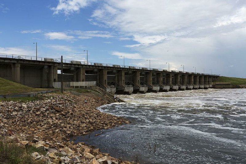
The economic growth of the Ashdown area was also boosted by construction of Millwood Dam, which took place from 1961-66 at a cost of $46.1 million. The dam on the Little River was designed to control flooding downstream on the Red River.
Millwood Lake covers 29,200 acres. Timber was left standing in much of the reservoir, which made it one of the hottest fishing lakes in the country in its early years. I spend about an hour at Two Rivers Museum in downtown Ashdown. Created in 2005 by the Little River County Historical Society, it's at the intersection of Main Street and U.S. 71. The museum is in the Bishop Building, which was built in 1908.
Heading north out of Ashdown, those traveling U.S. 71 cross the Little River just as it enters Millwood Lake. The river begins in the Ouachita Mountains of southeast Oklahoma and then crosses into Arkansas for the final 92 of its 220 miles. It empties into the Red River near Fulton.

As soon as I cross the river, I'm in a long stretch of bottoms that are now a part of Pond Creek National Wildlife Refuge, which covers almost 28,000 acres. It was established in 1994 in an area known as Pond Creek Bottoms, an intricate system of oxbow lakes, bayous and cypress breaks. The exit from those bottoms is rather dramatic as the northbound traveler begins to climb into the hills that will mark the rest of this journey.
After crossing the Little River, I'm in Sevier County. The county was created by the Arkansas Territorial Legislature in October 1828. It included parts of what are now Little River, Miller, Howard and Polk counties.
I pass by the turn to Ben Lomand (settled by immigrants from Scotland and named for a famous Scottish mountain) and go through the community of Falls Chapel. The poultry industry began to move into this area of the state in the 1920s. Giant companies such as Tyson Foods and Pilgrim's Pride later moved in. Sevier County was producing 50 million broilers annually by 2005. The poultry plants, in turn, brought Hispanic immigrants to southwest Arkansas. By the 2010 census, almost 30 percent of the county's population was Hispanic.
The timber industry also remains important in Sevier County with about 70 percent of its land covered by forests. Dierks Forests Inc. had holdings of 1.75 million acres in southwest Arkansas and southeast Oklahoma by the time it was sold to Weyerhaeuser Co. in 1969.
I pass through Lockesburg, which served as the Sevier County seat for 36 years. It's past noon by the time I enter De Queen, the current county seat. Lunch is downtown at Stilwell's, owned by a former De Queen mayor, Chad Gallagher. The restaurant is named for Arthur Stilwell, a Kansas City businessman who wanted to build a railroad from Kansas City to the Texas Gulf coast. Stilwell ran out of money in 1893. He headed to Holland in search of investors and met a coffee merchant named Jan de Geoijen. That coffee merchant helped Stilwell sell an additional $3 million worth of stock and finish the railroad.
A town along Stilwell's railroad was named De Queen, an Americanized version of de Geoijen's name, in 1897.

Tragedy struck De Queen on Oct. 1, 1899, when a fire destroyed downtown wooden buildings containing 54 businesses. A brick factory was built, and the reconstruction of De Queen began. Stilwell's Kansas City, Pittsburg & Gulf Railroad went into receivership the following year, but the business began to thrive again after being reorganized as the Kansas City Southern Railroad. New jobs moved to De Queen in 1909 when the railroad built a roundhouse and shop there. Additional jobs came from a booming timber industry.
Heading north out of De Queen after lunch, I pass through Gillham before leaving Sevier County and entering Polk County, which covers 858 square miles and had a population of 20,662 residents in the 2010 census. The county was named for President James K. Polk and was created when the Legislature separated it from Sevier County in 1844.
Stilwell chose a site three miles to the west of the county seat of Dallas for what became Mena. The railroad arrived there in August 1896. In a June 1898 special election, county residents voted to move the county seat to Mena.
The towns south of Mena--Grannis, Wickes, Vandervoort and Hatfield--were also products of Stilwell's railroad. Stilwell named the depot Grannis at what had been the community of Leon Station. He wanted to honor a railroad official with that name. The post office changed its name the next year, and Grannis was incorporated in October 1899. Wickes was named for Thomas Wickes, a vice president of the Pullman Co., which built railroad cars for Stilwell. The post office there was established in 1897. Hatfield was named for a worker who died while building the railroad.
Vandervoort was first known as Janssen, taking its name from the maiden name of Jan de Geoijen's wife. There was another town in Arkansas with a similar name, and mail was being mixed up on a regular basis. In 1907, the name was changed to Vandervoort to honor the mother of Jan de Geoijen. Vandervoort was his mother's maiden name.
And what about Mena? It takes its name from the nickname of de Geoijen's wife, Folmina Margaretha Janssen de Geoijen.
The first train pulled into Mena on Aug. 19, 1896. The city was incorporated the following month. The Bank of Mena opened in May 1897. By 1900, the population was 3,423. Mena had 5,737 residents in the 2010 census.
With the trip at its end, it's time to turn onto Arkansas 88 and begin the climb up Rich Mountain along the Talimena Scenic Drive. It's 39 degrees as I leave downtown Mena. By the time I reach the top of the mountain, where I'll spend the night at Queen Wilhelmina Lodge, it's 25 degrees with ice covering the stunted, wind-whipped oaks.
Editorial on 02/10/2019