The Arkansas River is still running too high and fast for the U.S. Army Corps of Engineers to assess flood damage to the navigation channel, the district engineer and commander for the agency's Little Rock district said Wednesday.
"The river has changed," said Col. Robert Dixon, whose three-year assignment is scheduled to end next month. "The river has changed dramatically. We're not exactly sure where the channel is right now. It may have moved."
Silting will be one of his agency's biggest challenges, he said. Not only that, the dredging needed to remove the silt and restore the 9-foot-deep channel will be problematic. The Corps of Engineers' only dredging vessel on the McClellan-Kerr Arkansas River Navigation System is in Oklahoma.
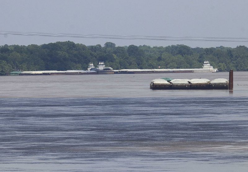
The Port of Little Rock was spared the worst of recent flooding, but silt has built up to the point that the port cannot move barges in its slack-water harbor. The port's executive director, Bryan Day, said it will take at least a month before normal barge operations resume.
Still, the Little Rock port fared better than any of the other ports on the river. While the Little Rock port had flooding, it was minor, and no products stored at the port were damaged, Day said.
"The Port of Little Rock fared very well compared to everybody else," he said. "We still have barges to unload. We have trains to unload. We had a very short interruption in business. But compared to my colleagues, we were fortunate."
Dixon, in a briefing during the Little Rock Port Authority board's monthly meeting, defended the decision by the Corps of Engineers in Oklahoma to unleash the volume of water downstream that the Arkansas River was unable to hold. That water was the result of torrential rainfall that filled flood-reduction lakes in Oklahoma and threatened dams.
"Our friends in Oklahoma did everything they could if you saw the amount of water coming down," he said. "They did, in fact, take the peak off. It would've been much worse. They couldn't do it any other way."
River flows for a short time reached 600,000 feet per second but generally were at 550,000 cubic feet per second during the peak of the flooding.
"We're still moving about 160,000 cubic feet per second," Dixon said. "Normally, at this time of year, it's 60[000] to 70,000. It gets as low as 30,000 in June.
"It is still unsafe to be out on the water. It is unsafe for our survey vessels to go out on the open water. We have tried to get some local surveying done. Even that is a challenge."
Even at 160,000 cubic feet per second, the river is carrying tons of silt.
"We're not sure where it's all going to fall out," Dixon said. "It isn't done falling. Right now, at 160,000 cubic feet per second, there's a lot of suspended solids moving down the river. When the flows slow down, that sediment is going to start dropping out. Where it's going to go, we're not really sure."
The Corps of Engineers is waiting for river flows to fall to 60,000 cubic feet per second, which Dixon said will allow the drainage structures built into the navigation system to self-scour some of the sediment. Only then will the survey vessels begin their work, he said.
"We need to know the river is doing what it is supposed to be doing and give it a chance and not get false data," Dixon said. "We don't want to get out there too early," decide the river is OK "and it not be safe a week later."
Day said patience is required, given the length of the navigation system on the Arkansas River, the shortage of dredging equipment and the wider flooding problems in the region.
"They've got 415 miles of river to inspect," Day said. "There's one dredge on the system right now. They're trying to bring others in, and they will. They do a really good job.
"But remember that the Arkansas is not the only river that's flooded. The lower Mississippi, the lower Missouri is flooded, the upper Missouri is flooded, the upper Mississippi. It's been a wet, wet spring for the inland river system."
The navigation system has 18 locks and dams, and needs a 250-foot-wide channel with a minimum depth of 9 feet for safe barge travel.
Through the first five months of this year, the system moved 4 million tons of cargo. While the first four months averaged about 1 million tons per month, May's total fell dramatically -- to 150,000 tons -- because of the flooding.
The locks and dams came through the flooding relatively unscathed, Dixon said.
"The dams did great," he said. "They are fine. They performed exactly as intended. The locks did well. We have a couple that are challenged right now."
Two locks have gates that aren't lining up "exactly right," Dixon said. "We anticipate ... that our folks are going to get all of the maintenance things in place and the locks functioning the way they should before the river is in a position to navigate.
"Our infrastructure will not be a limiting factor in returning to business. It will be the river itself."
Dixon expressed concern, not only about the silting, but about the ability to get dredging equipment in to remove the silt and restore the channel.
"Dredging is going to be a problem for us," he said. "I'm not going to sugarcoat that at all. There's a limited amount of dredging assets in the system, and right now we only have one contract open for dredging. That's to cover for both [Arkansas and Oklahoma].
"The entire length of [the river] is going to have to have some dredging. I'm not sure where it's going to self-scour, I'm not sure where it's going to pile up."
The Corps is reaching out far and wide to find available dredging vessels.
"I don't know how bad the problem is going to be," Dixon said. "I don't know what assets we are going to be able to bring in. We're reaching out to industry, to the rest of the Corps, to see what assets that we can bring in as quickly as possible to get surveys and to address the problems and get the channel open."
About 100 barges are waiting downriver to make their way to the Little Rock port, according to port officials. Industry relying on those cargo loads likely will look for other options to get the products they need, the officials said. For Day and other port operators, all they can do is wait.
"The concerns we have are really the unknowns," Day said. "We don't know what the river is going to look like. We don't know what the locks and dams are going to look like until it drops. We're probably still three to four weeks out before we are seeing consistent barge traffic on the river."


A Section on 06/20/2019