6:27 p.m. UPDATE:
The National Weather Service in North Little Rock issued a tornado watch for parts of Arkansas, Oklahoma and Texas until 1 a.m. Thursday. In Arkansas, the alert stretches from Miller County to as far northeast as Jackson County. The Little Rock metro area and cities of Conway, Pine Bluff and Camden are all included in the watch.
Flash flood warnings were in effect for the central Arkansas cities of Little Rock, North Little Rock and Benton until 8 p.m.

5:34 p.m. UPDATE:
The National Weather Service issued a tornado warning for Maynard, Dalton and Warm Springs until 6 p.m.
A tornado watch issued earlier in the day for much of western and northern Arkansas continued to be in effect until 8 p.m.
The agency issued a flash flood warning for Clinton, Fairfield Bay and Shirley that expires at 7:30 p.m.
4:46 p.m. UPDATE:
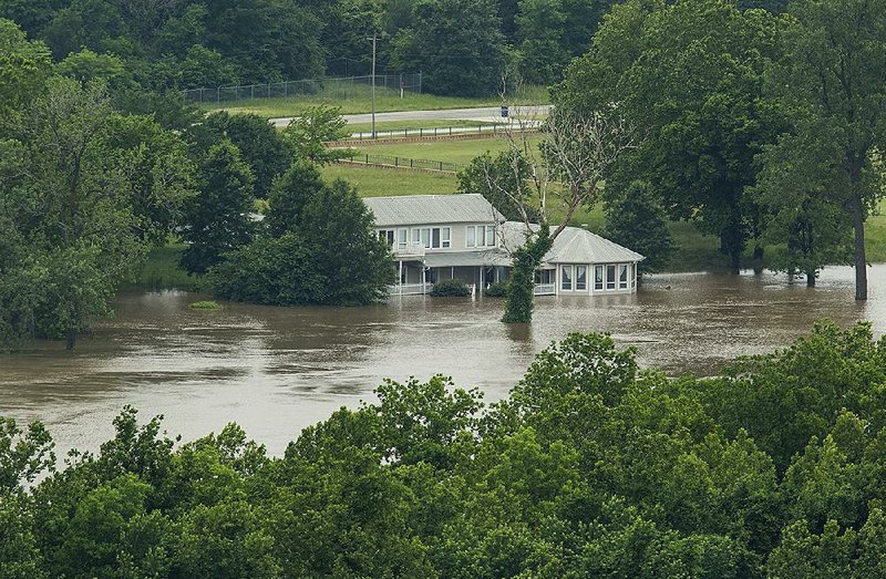
Arkansas Gov. Asa Hutchinson said Wednesday he has increased emergency funding in response to historic and “devastating” flooding along the Arkansas River, while also signing off on a letter to the president seeking additional federal support.
The governor said he signed an order boosting funding to deal with flooding to $350,000, up from $100,000. Hutchinson said during an afternoon news conference that he also sent a formal request to President Donald Trump asking for help from federal agencies beyond FEMA.
Heavy and persistent rains in Oklahoma and Kansas swelled lakes there, prompting the Army Corps of Engineers to release water from a hydroelectric dam near Tulsa.
It created a surge of water that’s swept down the Arkansas River, and that’s been causing record-setting water levels in western Arkansas. Meanwhile, cities downstream are bracing for floods.
Trump tweeted Tuesday that he was aware of the rising waters and vowed federal disaster agencies “will do whatever is necessary to help out with what has turned out to be Record Flooding.”
Hutchinson called the flooding potentially “devastating.”
“This is a flood of historic magnitude. It surpasses all Arkansas river flooding in our recorded history,” he said. “That should be enough to get everybody’s attention.”
In his letter to the president, Hutchinson cited uncertainties about damages the floods might cause, noting concerns that record-setting water levers are pushing state infrastructure further than what it’s ever experienced.
Hutchinson said he's issued four emergency orders so far this year, costing an estimated $9.6 million, which he said will “severely deplete” the governor’s emergency relief fund.
“I have determined that these storms and flooding are of such severity and magnitude that effective response is beyond the capabilities of the state and affected local government,” he wrote in the letter. “Federal assistance is necessary.”
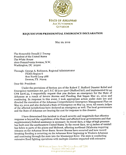
Hutchinson said he wasn’t sure how much financial support the state could get if the president signs a disaster declaration, which allows him to free federal resources and funds. The request comes after a phone call he made briefing Trump about the flooding on Tuesday.
Last week, the governor ordered the Arkansas National Guard to follow the river flooding, and he deployed high-water rescue teams to areas already experiencing high waters.
Weather officials said nearly every city along the Arkansas River's path, including Little Rock, will likely see it swell to major flood stages throughout the week and into early June.
Some 400 people have voluntarily evacuated their homes in flood-hit areas, Hutchinson said, with the Fort Smith area seeing the first wave of rising waters.
Officials have reported at least one death related to the flooding in an apparent drowning near Fort Chaffee. Local police said a 64-year-old man apparently drove behind a barrier before a diving crew found him and his submerged vehicle.
The governor exhorted people to heed emergency warnings if they’re given, including evacuation orders. He urged people to not go behind roads that are blocked off.
State and local officials said Tuesday that water overcame two levees in Paris and another near Toad Suck.
Hutchinson said he visited the Toad Suck Ferry Lock & Dam earlier in the day and it was entirely underwater.
Other levees and flood infrastructure in the area appear to be holding back the water, they said, but the historic river levels are testing the flooding infrastructure in ways they haven’t experienced in the past.
The river near Fort Smith, the second-largest city in Arkansas, appeared to have crested Wednesday morning, breaking its previous record set in the 1940s.
“A lot of our levees will be under pressure for a long extent of time,” said Arkansas Department of Emergency Management Director A.J. Gary. “We don’t know if those levees will hold.”
— Youssef Rddad

1:30 p.m. UPDATE:
A tornado watch has been issued for a large part of western and northern Arkansas.
These counties are under the watch until 8 p.m.: Baxter, Boone, Conway, Fulton, Garland, Izard, Johnson, Logan, Marion, Montgomery, Newton, Perry, Pike, Polk, Pope, Scott Searcy, Stone, Van Buren and Yell.
11:45 a.m. UPDATE:
The Arkansas River at Dardanelle reached record a flood level on Wednesday morning, and it's expected to rise further in the coming days.
National Weather Service measurements show the river reached 44.22 feet in the area, surpassing the previous record of 44.1 feet that was set in 1943. Officials said they expect the river to continue swelling in the coming days, potentially reaching 45.5 feet by Friday evening.
A surge of water has been moving downstream following persistent and heavy rains in Oklahoma that have filled up lakes there that act as a natural flood reduction system for the Arkansas River.
[DRONE VIDEOS: Footage shows aerial views of flooding around state]
Measurements taken near Fort Smith show the water levels there broke a nearly 75-year-old record. Reports show the river reached its crest Wednesday morning at just over 40 feet, nearly 10 feet over its major flooding stage.
Several communities downstream have been filling and stacking sandbags and bracing as the Arkansas River rises. State and local officials have issued warnings for residents to heed any emergency orders if they're issued.
At least one person was killed in Barling, and several people have had to leave their homes because of the rising waters.
Weather officials on Wednesday were also monitoring a round of severe storms moving into Arkansas with the potential of drenching parts of the state with up to four inches of rain.
They said the added rain has the potential to worsen the flooding or prolong it.
— Youssef Rddad
7:55 a.m. UPDATE:

Forecasters predict roughly the northwest half of the state will be at a slight to enhanced risk of severe thunderstorms starting Wednesday afternoon, and several inches of rain are expected in western parts of the state.
Large hail and damaging winds will be the primary concern if severe storms develop Wednesday, though a few tornadoes are possible as well, according to the National Weather Service in North Little Rock. The threat of these storms is expected to continue overnight.
Heavy rain will also be possible across much of western Arkansas through Thursday morning, forecasters said. According to the agency, 2 to 4 inches of rain may fall in those areas, which could cause flash flooding and worsen or prolong ongoing river flooding.
Check back to keep up with the latest details on Arkansas’ weather.
— Josh Snyder