Hurricane Dorian began a turn to the north-northwest Tuesday as it left the Bahamas and headed toward the U.S. mainland, where it is expected to cause significant damage.
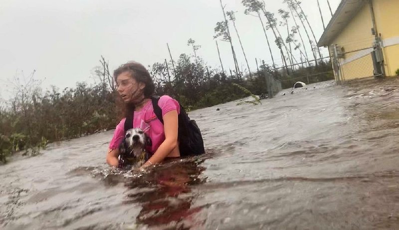
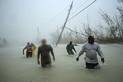
As of Tuesday evening, the storm was crawling north of Grand Bahama Island, with its core finally pulling away from the battered region. Meanwhile, tropical-storm force wind gusts had reached Florida's Treasure Coast along with "significant" flooding, according to the National Weather Service.
Although its peak winds have weakened since it was a Category 5 hurricane Sunday and Monday, the storm has grown in size, and winds are covering more territory.
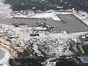
Dorian, now a Category 2 storm with 110 mph winds, slammed into the northwestern Bahamas over the weekend producing 185 mph winds and a 23-foot storm surge. Video and images emerging from the Bahamas show absolute devastation on Abaco and Grand Bahama islands, where the eye of the storm made landfall.
[Video not showing up above? Click here to watch » https://www.youtube.com/watch?v=_iQhCaFnP7I]
At a news conference late Tuesday, Prime Minister Hubert Minnis said the death toll had risen to seven and that more deaths were expected.
The storm destroyed or severely damaged thousands of homes, crippled hospitals and trapped people in attics.
"This was a crisis of epic proportions," said Marvin Dames, the minister of national security of the Bahamas.
"It's total devastation. It's decimated. Apocalyptic. It looks like a bomb went off," said Lia Head-Rigby, who helps run a hurricane relief organization and flew over the Bahamas' hard-hit Abaco Islands. "It's not rebuilding something that was there. We have to start again."
She said her representative on Abaco told her that "there's a lot more dead" and that the bodies were being gathered.
Emergency authorities struggled to reach victims in conditions too dangerous even for rescue workers, and urged people to hang on until help could arrive.
"We don't want people thinking we've forgotten them. ... We know what your conditions are. We know if you're stuck in an attic," Tammy Mitchell of the Bahamas' National Emergency Management Agency told ZNS Bahamas radio station.
Red Cross spokesman Matthew Cochrane said more than 13,000 houses, or about 45% of the homes on Grand Bahama and Abaco, are believed to be severely damaged or destroyed. U.N. officials said more than 60,000 people on the hard-hit islands will need food, and the Red Cross said some 62,000 will need clean drinking water.
"What we are hearing lends credence to the fact that this has been a catastrophic storm and a catastrophic impact," Cochrane said.
Lawson Bates, a staff member for Arkansas-based MedicCorps, flew over Abaco and said: "It looks completely flattened. There's boats way inland that are flipped over. It's total devastation."
The Red Cross authorized $500,000 for the first wave of disaster relief, Cochrane said.
U.N. humanitarian teams stood ready to go into the stricken areas to help assess the damage and the country's needs, U.N. spokesman Stephane Dujarric said. The U.S. government also sent a disaster response team.
STORM SURGE, WINDS
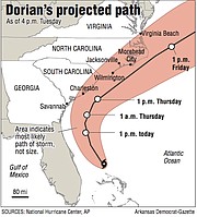
Attention now turns to the U.S. mainland, with hurricane warnings and watches stretching from the Florida coastline northward to the North Carolina Outer Banks.
Tropical-storm conditions, with sustained winds of more than 39 mph, were already affecting Florida's Treasure Coast late Tuesday, and were expected to expand farther north toward Jacksonville, Fla., today. Hurricane conditions, with sustained winds of at least 74 mph, are possible if the storm wobbles west.
Farther north, the National Hurricane Center projected a life-threatening storm surge and dangerous winds from coastal areas to the North Carolina Outer Banks, "regardless of the track of Dorian's center."
As of 10 p.m. CDT, Dorian was centered about 95 miles east of Cape Canaveral, Fla. Maximum sustained winds were being clocked at 110 mph. It was moving to the north-northwest at 6 mph.
Radar from central Florida showed Dorian's outer rain bands producing heavy rain and strong winds inland. "Wind gusts to tropical storm force are now occurring along the Treasure Coast of Florida," the National Hurricane Center wrote. "A sustained wind of 42 mph and a wind gust of 60 mph were recently reported at a weather station in Melbourne Beach, Florida."
Social media photographs showed ocean water reaching the dunes at Satellite Beach, which is just north of Melbourne, Fla.
"We have received reports of significant coastal flooding and major beach erosion from Sebastian Inlet south to Saint Lucie Inlet, along the barrier islands and Intracoastal Waterway," the National Weather Service forecast office in Melbourne tweeted.
The office added that is "expecting worse conditions" for the midnight high tide along the Space Coast.
The storm has grown larger over time, and the Hurricane Center wrote that the area of hurricane-force winds was likely to expand in the next few days.
The latest forecast from the Hurricane Center called for Dorian to remain a Category 2 storm as it makes its closest pass to Florida and northward to the Carolinas.
Hurricane warnings are in effect for much of the Florida east coast from Sebastian Inlet north.
Areas that are especially vulnerable to storm-surge flooding, such as Jacksonville, could see significant flooding depending on the exact track and timing of the storm.
Rainfall along the Florida coast could reach 3 to 6 inches.
COASTLINE IN PATH
Meanwhile, conditions were expected to deteriorate early today in coastal Georgia, by late today in South Carolina and by Thursday in North Carolina. Where and whether Dorian makes landfall will depend on the exact trajectory of its turn relative to the coast as it veers north and then starts to bend northeastward.
A tropical-storm warning was in effect for coastal Georgia, while a hurricane warning covered the entire South Carolina coast north to Surf City, N.C. A hurricane watch spanned from Duck, N.C., to the North Carolina/Virginia border.
The Georgia and South Carolina coastlines are particularly vulnerable to storm surge flooding, even from a storm that does not make landfall, because of the shape of the land on and just offshore, as well as the effects of sea level rise and land subsidence over time. The surge could reach 3 to 5 feet in Georgia and 4 to 7 feet from the South Carolina coast north to Cape Lookout, N.C.
Late Tuesday, the federal government granted a request for a federal disaster declaration for North Carolina.
Places even farther north from Virginia Beach to the Delmarva and even up to Cape Cod could get clipped by the storm Friday and Saturday, with heavy rains, tropical-storm force winds and coastal flooding.
A tropical-storm watch was in effect from the North Carolina/Virginia border to Chincoteague, including the Virginia Beach area, as well as the Chesapeake Bay area from Smith Point southward.
"The risk of wind and rain impacts along portions of the Virginia coast and the southern Chesapeake Bay are increasing," the Hurricane Center wrote.
Dorian is tied for the second-strongest storm ever recorded in the Atlantic Ocean, behind Hurricane Allen of 1980, and, after striking the northern Bahamas, tied with the 1935 Labor Day Hurricane for the title of the strongest Atlantic hurricane at landfall.
It is only the second Category 5 hurricane to make landfall in the Bahamas since 1983, according to Phil Klotzbach of Colorado State University. The only other is Hurricane Andrew in 1992. The international hurricane database dates back continuously only to 1983.
Information for this article was contributed by Andrew Freedman and Jason Samenow of The Washington Post; by Ramon Espinosa, Danica Coto, Michael Weissenstein, Tim Aylen, Russ Bynum and Seth Borenstein of The Associated Press; and by Elisabeth Malkin and Frances Robles of The New York Times.

A Section on 09/04/2019