HOT SPRINGS -- The due-north track Hurricane Laura is expected to take from the Gulf Coast into southwest Arkansas Thursday didn't give it much time or space to dissipate, making it likely the Category 4 cyclone will bring tropical storm-levels of wind and rain to Garland County.
Gov. Asa Hutchinson declared an emergency ahead of Hurricane Laura and set aside $250,000 to prepare for the storm's impact.
Hutchinson said Wednesday the state will have search and rescue teams on standby.
Meteorologist Jeff Hood with the National Weather Service in North Little Rock said Wednesday the system could drop as much as 8 inches of rain in parts of the county, with wind gusting up to 50 miles per hour.
"Within the larger scale, we're talking about 4 to 6 inches of rainfall, but within eastern portions of Garland County and along Interstate 30 and up towards Little Rock, we're talking about a 6- to 8-inch bull's-eye," he said.
Bo Robertson, Garland County Department of Emergency Management director, said Wednesday flooding and flash flooding are expected in the county, prompting the Fire Department to put its swift water rescue team and shallow-draft Zodiac inflatable boat on standby.
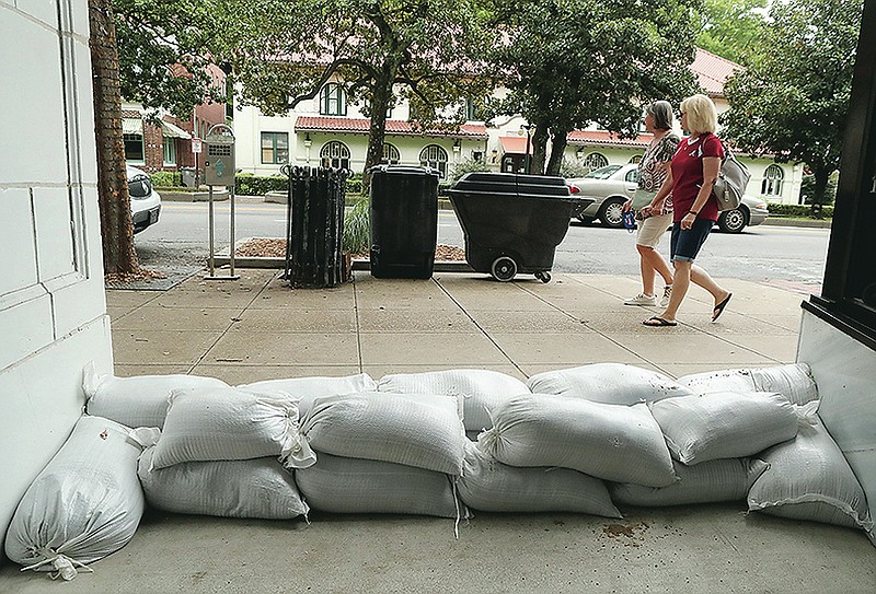
The Public Works Department filled about 800 sandbags Tuesday and Wednesday for distribution in the flood-prone downtown area, department Director Denny McPhate said Wednesday. He said more will probably be filled Thursday. Sandbags can be purchased at stores such as Lowe's Home Improvement and Sutherlands, he said.
The Hot Springs Police and Fire departments are discouraging parking on Central Avenue today. Vehicles should be parked on side streets or in the Exchange Street Parking Plaza, the city said in a news release.
"Vehicles can be swept away in 1 foot of water, and a person of small stature can be swept away in less than an inch of water," the release said. "Cars that are swept away by floodwaters cause damage to nearby surroundings, such as breaking windows, colliding with other vehicles or buildings, and can even hit people.
Robertson said emergency response planners don't expect to have to open congregate shelters such as gymnasiums, school safe rooms and the Hot Springs Convention Center to evacuees from Louisiana and Texas.
"We have been in contact with Red Cross regarding the possibility of sheltering, however, we're hopeful the hotels will fill up before any sheltering is required," he said. "They're hopeful any evacuees coming from Texas, Louisiana will fill up the hotels first."
A more indirect path into the state would allow additional time and distance for the storm to weaken over land, Hood said, but the straight line it's tracking from the Gulf Coast isn't likely to degrade the massive cyclone to a level below tropical storm status.
"It's taking a nearly south-to-north track into southwest Arkansas," he said. "The path it's taking is practically the shortest distance between the Gulf of Mexico and the state of Arkansas. One thing it has going for it is the shortest distance between two points. The other is it could potentially make landfall with 140-mph winds.
"It will rapidly weaken, but even from a starting point of 140 mph, we're still going to see quite a strong storm as it makes its way into the state."
The expected path Wednesday would put Garland County east of the eye, the most powerful side of the storm, but Hood said that doesn't mean the heaviest rain will be on that side.
"The right side of the track for the rainfall isn't as big of a deal when it makes its way inland as it is when it's offshore," he said. "The heaviest rainfall associated with Cristobal back in June wasn't found on the right-hand side or the east side of the track with that system. That concept or idea is a little bit less important when it makes its way a state or two inland."
Hood said wind speeds are expected to slow as the storm reaches Garland County.
"For Garland County, that's when we're going to be transitioning from sustained winds around 40 to 45 mph, maybe a little bit stronger, down to sustained winds probably around 30 mph," he said. "Southwest Arkansas looks to have those 40-plus mph sustained winds, and we'll be looking at that scaling down as it makes its way across Garland County and into central Arkansas.
"I would anticipate sustained winds around 30 mph, and then we're going to see gusts of 40 to 50 mph at times."
Entergy Arkansas said it's mustering close to 1,200 workers across south Arkansas in anticipation of large-scale power outages that could last for days. That number includes more than 100 line workers from utilities outside the storm's path. Crews will move north into Garland County and other parts of central Arkansas if needed, the utility said.
"Vacations and days off have been canceled for line crews and support workers," Brandi Hinkle, a communications specialist for Entergy, said Tuesday. "Vegetation crews are scouting key circuits for threats from windblown trees. Supplies like poles and transformers are being double-checked and prepped for transport to where needed. Logistics teams are making arrangements to secure hotels and food caterers for line workers in south Arkansas."
County Judge Darryl Mahoney said Wednesday he offered the parking lot at the Garland County Detention Center as a staging area.
Entergy dropped lakes Hamilton and Catherine to the lower ends of their operational bands earlier this week. Wednesday it said the lakes will be lowered further. "This will drop them both about 6 (inches) below the bottom of their rule curves," Entergy said.


