As a storm system moves toward Arkansas, meteorologists are warning about the possibility of flash flooding late today and early Saturday followed by a drop in temperatures.
The forecast shows a drop of more than 20 degrees from midafternoon today to midafternoon Saturday -- after the severe weather passes through.
The below-freezing conditions will produce 1-2 inches of snowfall Saturday afternoon in parts of Northwest Arkansas, according to the National Weather Service.
The biggest concern among forecasters is a deluge of rain.
"You could see 2 to 4 inches and maybe as much as 6 inches in some areas," said Craig Sullivan, a meteorologist with the National Weather Service in Tulsa. "There's a pretty good chance that could lead to some flash flooding and significant rises on rivers."
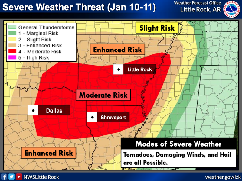
As the storm system moves east and engulfs the state, there will be a moderate risk of tornadoes across southern Arkansas from Fouke in Miller County to El Dorado in Union County, according to the National Weather Service in Shreveport.
By Saturday afternoon, temperatures are expected to drop. With that drop comes the possibility of up to 2 inches of snow across Northwest Arkansas, Sullivan said.
Central Arkansas is expected to see significant rainfall and a drop in temperatures, but snow is not in the weekend forecast for Little Rock and surrounding areas.
Scattered showers began Thursday and were expected to continue this morning. As of late Thursday, meteorologists were predicting heavier rainfall tonight related to a line of severe thunderstorms moving through from Texas and Oklahoma.
Willie Gilmore, a meteorologist with the National Weather Service in North Little Rock, said the worst of the rainfall will arrive in Central Arkansas around midnight, and rain will continue into Saturday morning. By daybreak Saturday, the heavy rain will have tapered off, he said.
Sullivan said the lack of vegetation in the winter makes flash flooding more likely during heavy rainfall because there is nothing to soak up the water.
Temperatures will drop into the 40s Saturday afternoon and will get below freezing after the sun goes down, Gilmore said. The low for Little Rock on Saturday will be 27 degrees, according to AccuWeather.
"We're not really expecting to see anything as far as winter weather," Gilmore said, referring to the possibility of snowfall in the central part of the state.
Even so, residents are being warned to brace for severe thunderstorms that will be moving across the state late today and early Saturday. There will be a lot of rain and wind, and a chance of tornadoes in the southern region, meteorologists said.
The National Weather Service is warning that gusts could reach 35 mph in Little Rock and 45 mph in Brinkley northeast of the capital city.
As for Sunday, there will be more sunshine, less wind and a slight increase in temperatures, meteorologists said. The highs in Little Rock for that day will be around 50 degrees, according to forecasts.
Kerri Case, a spokeswoman for Entergy, said crews will be prepared today and Saturday in case the storm system results in power outages.
"We're already spread out, ready to react," she said. "We're fanned out all across the state. It's Arkansas. Thunderstorms are pretty common."
Metro on 01/10/2020