Meteorologists late Wednesday expanded the ice storm warning over Central and east Arkansas to include south Arkansas.
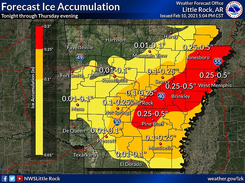
"The highest ice totals are now expected to fall in an area approximately bounded by the area in between Camden, southern Pulaski County, Monticello, Brinkley, and West Memphis," according to a news release from the National Weather Service in Little Rock.
Forecasters expected freezing rain and ice to stop by Thursday afternoon, though temperatures were expected to stay below freezing through Friday morning, then potentially warm slightly before what the news release called "an incredibly cold, arctic air mass" building across Arkansas over the weekend and into the next week.
5:19 p.m.: Forecasters: Freezing rain expected in Central Arkansas
Utility companies across the state, including Entergy Arkansas and electric co-ops, were preparing Wednesday for potential power outages.
“Ice accumulating on trees and power lines can result in power outages,” said David Lewis, a spokesman for Entergy. “It’s too soon to determine the extent of this storm’s threat to Entergy Arkansas’ equipment, but customers should prepare to be without power for several days.”
Through mutual-aid agreements, utility companies were already readying contractors to help in case of widespread outages, officials said.
About 260 additional line workers were inbound on Wednesday, including employees of Entergy Louisiana and contractors normally assigned to Entergy Louisiana and Entergy Texas, Lewis said in an email. Another 100 damage-assessment specialists were on the way Wednesday afternoon.
The number of vegetation contractors, who are used to clear roadways of fallen trees, was at 344 as of Wednesday evening, and the total field workforce committed to the weather event as of Wednesday was nearly 900, Lewis said.
Rob Roedel, Electric Cooperatives of Arkansas spokesman, reminded customers that it could take some time to restore power if it goes out in an ice storm, but that utility companies will be working as quickly as possible.
“We are always at the mercy of Mother Nature and weather,” Roedel said. “We can’t begin restoring the service until we know exactly what is wrong with the system. We have to wait for Mother Nature to do her worst, and then we come and see what the damage is, and then develop a plan to restore the system as quickly as possible.”
[LIST: School closings » arkansasonline.com/closings/]
5:10 p.m.:
Eastern parts of the state including Walnut Ridge, Jonesboro and Paragould were already reporting widespread travel issues with freezing drizzle on Wednesday afternoon, according to a National Weather Service meteorologist.
Dylan Cooper said icy patches also were being reported in Northwest Arkansas and other northern regions.
Freezing rain was predicted to start from central to eastern Arkansas as the sun set and temperatures dropped. The regions could see as much as a half inch of ice, and localized areas could see more, he said.
“Whatever happens overnight tonight is not going to be going anywhere,” Cooper said. He said temperatures will remain below freezing across nearly the entire state in the coming days.
The coldest temperatures are predicted for Sunday and Monday, with wind chill values in Northwest Arkansas approaching negative 10 degrees or colder, he said. Much of the state will see wind chill values that make temperatures feel near zero or into the negative single digits.
“This is a prolonged cold event with multiple opportunities for winter weather,” Cooper said. “We are getting into dangerously cold territory, and it is potentially a significant risk to life if people are outside or exposed to it.”
4:38 p.m.:
The Arkansas Department of Transportation continued Wednesday to work around the clock with nearly every person and piece of equipment as the ice storm approached, according to a department spokesman.
“Dealing with snow and sleet is one thing, but dealing with ice is a new ball game altogether,” Dave Parker said. “It will not be safe for anybody to be out in.”
Any icy precipitation the state receives from the storm is unlikely to melt in the coming days and will make clearing roads difficult, he said.
“It doesn’t mean the entire interstate has to be icy for you to hit a patch of ice and slide,” Parker said.
Eugene Nuff, the road superintendent of Craighead County in northeast Arkansas, said his department was limited in its ability to tackle the ice conditions predicted for the area, but that his crews were doing everything they could.
“All we do is throw sand out,” Nuff said. “We have two sand trucks and seven or eight pickups.”
It has been years since the county, which includes Jonesboro, has seen any ice on the roadways, Nuff said. He said any residents who choose to drive will need to take their time and expect that a few roads could become impassable.

EARLIER:
Sunset will lower temperatures and support the start of the freezing rain Wednesday night, said Thomas Jones, meteorologist with the National Weather Service, adding rain amounts will increase throughout the night.
While the ice forecast was uncertain for Central Arkansas on Tuesday, the system shifted further south, increasing the likelihood of freezing rain in the region.
The very northern portion of the state may see less ice than previously predicted as colder than previously predicted weather could turn the ice into sleet, according to Jones.
EARLIER:
An ice storm warning is in effect for central and eastern portions of the state through Thursday morning, according to the National Weather Service.
The remainder of the state is under a winter weather advisory through Thursday morning, according to a Wednesday morning briefing from the National Weather Service.
Forecasters say light freezing rain or freezing drizzle is expected over northern and central Arkansas on Wednesday, which can create a thin coat of ice.
Wednesday night into Thursday morning an accrual of a quarter up to more than half an inch of ice is expected in some areas, which will likely cause tree damage and power outages in some places, according to the briefing.
The coldest air will arrive this weekend into early next week, the briefing states.
Temperatures Sunday and Monday mornings will be in the single digits and teens, with highs in the teens to 20s, according to the National Weather Service.
A storm system arriving Monday brings good chances of snow, forecasters predict.
Those without proper heating should make preparations, forecasters caution, and pets and/or animals who reside outside should be checked on frequently or brought into shelter, if possible.
Warming Shelters:
Don Owen Sports Complex, 10 Lower Ridge Road, Conway, offers a warming center until March 1
First United Methodist Church’s Family Life Center, 1100 Central Ave., Hot Springs, will offer an overnight warming shelter from Thursday through Tuesday morning
Union Rescue Mission, 3001 Springer Blvd., Little Rock, has 20 male and 20 female beds, beginning Wednesday, check-in 2 p.m. check out 6:30-7 a.m.
Compassion Center, 4210 Asher Ave., Little Rock is allowing people to stay inside during the day
The Van at the Fairgrounds, 2600 Howard St., Little Rock, starting Wednesday at 7 p.m.
From His Throne Ministry, 2501 S. Arch St, Little Rock, starting 8 p.m. accepting 34 individuals first- come, first-serve basis.
North Little Rock Community Center, 2700 Willow St., North Little Rock, open from 5:30 p.m. Wednesday until 7 a.m. Thursday
Visit idrivearkansas.com for real-time updates of traffic impacts and road conditions. See school and business closings at arkansasonline.com/closings.