BENTONVILLE -- Benton County will ask for state funding to clean up the mess left by flooding last week. The county and local cities estimate total public infrastructure damages to be in excess of $5 million.
Benton County Judge Barry Moehring signed an emergency disaster declaration Wednesday, according to a county news release.
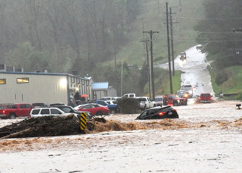
Rogers received 7.17 inches of rain from 7 a.m. April 28 to 7 a.m. April 29, according to the National Weather Service in Tulsa. Centerton received 3.30 inches and 3.04 inches fell on Pea Ridge, according to the Weather Service.
The declaration allows the county and affected cities to request assistance from the Arkansas Department of Emergency Management for uninsured public sector damages attributed to the storm and for repair to structures to predisaster conditions, the release stated.
The countywide threshold for state assistance is $861,009. That number is formulated on a per capita of $3.89 per person based on the 2010 census, Robert McGowen, county administrator of public safety, said Thursday. In order to receive federal assistance, the threshold statewide for damage caused by the weather event is $4,019,000, the release stated.
If the damage is extensive enough in Benton County and other counties within the state, the governor may declare a statewide disaster which, if confirmed by Federal Emergency Management Agency, could trigger assistance from the federal government, the release stated.
If the county receives a state disaster declaration, each entity could receive up to $500,000 from the state. The percentages are 35% state share and 65% local share, McGowen said.
If the county receives a presidential disaster declaration, there is no limit on the amount of funding received and each entity is reimbursed at 75% from the goverment with a 25% local share, McGowen said.
Individuals who sustained damage to uninsured homes are encouraged to report it through the county website, which has a click-through banner at the top, the release stated.
These reports will also be communicated to state and potentially to federal agencies for damage assistance. The agencies will determine if personal property damage assistance will be awarded. Only damage to homes, dwellings or other occupiable structures may be covered, the release stated.
"Given the damage our local mayors, Benton County Road Department, Benton County public safety team and I have seen from touring the impacted areas, I believe a declaration is appropriate," Moehring said. "If the monetary damages of the storm are significant enough, then we'll be able to receive additional assistance for repairs."
Floodwater washed out a new area of the Lake Bella Vista dam in Bentonville. A news release from the city said the structure "suffered an additional failure" about 50 feet in width, west of the east spillway.
The dam was first damaged during flooding in 2008 and has had additional flood damage since.
Weather Service staff were in Benton County on April 29 to investigate a possible tornado that was spotted 3 miles south of Garfield about 8 a.m. April 28. McGowen said the event was not a tornado.
More News
Local forecast
There is a 20% chance of showers and thunderstorms after 1 p.m. today with a high near 67. Tonight, there is a 40% chance of showers and thunderstorms mainly after 1 a.m. with a low around 56.
On Saturday, there is a 40% chance of showers and thunderstorms, mainly before 1 p.m. with a high near 77. Saturday night calls for a chance of showers and thunderstorms, then showers likely and possibly a thunderstorm after 1 a.m. with a low around 64. The chance of precipitation is 60%.
On Sunday, there is 40% chance of showers and thunderstorms with a high near 74. Sunday night has chance of showers and thunderstorms before 1 a.m. with a low around 47. The chance of precipitation is 30%.
Source: National Weather Service