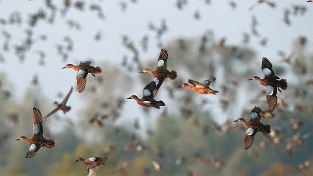
Little water is available for ducks, making it challenging for duck hunters to find opportunities.
Anecdotal reports from around the state the past week indicated that ducks were concentrated in the few areas that have water. But as Luke Naylor, Arkansas Game and Fish Commission waterfowl coordinator, said last week before opening weekend, without a good amount of rainfall in the state, the ducks that have arrived will adjust to the lack of habit and the hunting and seek safer refuge, and areas where duck success is high over the first few days of the season will likely see those harvest numbers quickly drop.
At some wildlife management areas that are pumping water, such as Steve N. Wilson Raft Creek Bottoms WMA, dry ground has is slowing efforts to fill all of the fields.
Popular duck hunting destinations such as Bayou Meto WMA and neighboring Cut-Off Creek are mostly dry. Southwest Arkansas WMAs are dry. Many ducks are concentrated at Lake Millwood.
River water is filling Dave Donald Black River WMA. The three hunting areas in Big Lake WMA in northeast Arkansas are at least three-quarters dry. The Shirey Bay Rainey Brake WMA was no more than 35% covered as of Monday.
Harris Brake Lake has allowed the Harris Brake WMA to have about half to three-quarters coverage in its hunting area. Ed Gordon Point Remove WMA is mostly dry, but pumping of waterfowl impoundments began on Oct. 27 and will continue as long as water levels in Point Remove Creek allow. Some areas of the WMA have sufficient water for hunting. Further west, Frog Bayou WMA has some areas with good coverage of water for duck habitat.
Hunting daily begins 30 minutes before sunrise, with the day's shooting done at sunset. Daily bag limits are unchanged from last year: 6 ducks, which may include no more than 4 mallards (2 hens), 1 scaup, 3 wood ducks, 1 pintail, 2 redheads, 2 canvasbacks, 2 black ducks, 1 mottled duck. If not listed, up to 6 ducks of a species (such as teal) may be taken. The coot daily bag limit is 15 and the merganser daily limit is 5, which may include no more than 2 hooded mergansers. The first of the three splits of the 60-day duck season will conclude Monday at sunset. The second split will open Dec. 11 and run until Dec. 23. The final section of the season runs Dec. 26-Jan. 31.
NORTHEAST ARKANSAS
BIG LAKE WMA
North Woods GTR Mast production is good. The Bo Dock gauge currently reads 233.6. Target level is 235.7 with 10% flooded.
South Woods GTR Mast production is fair. The 7-mile gauge is currently at 232.8 feet. Target level is 234.5 feet with 25% flooded. Lateral ditches and come borrow pits are flooded.
Simmons Field A good amount of millet and sedge is present. Seed production is very good in the North Unit, Middle and South fields. 5% flooded.
DAVE DONALDSON BLACK RIVER WMA
Upper Island GTR Moderate mast crop. Water level is 269.55. Target level is 269.5. 100% flooded.
Lower Island GTR Moderate mast crop. Water level is 268.05. Target level is 268. 100% flooded.
Upper Reyno GTR Moderate mast crop. Water level is 266.9. Target level is 266.9. 100% flooded.
Lower Reyno GTR Moderate mast crop. Water level is 266.45. Target level is 266.3. 100% flooded.
Winchester GTR Moderate mast crop. Water level is 261.9. Target level is 263.7. 5% flooded.
EARL BUSS BAYOU DEVIEW WMA
South Oliver GTR Mast production has been good. 0% flooded.
Thompson Tract GTR Mast production has been good. The area is 0% flooded. The Thompson Tract GTR will be allowed to rise and fall naturally without the gates being operated beginning with this season. The action is an effort to help the next generation of forest.
Lake Hogue WRA Normal pool level. Primarily deep open water habitat.
SHIREY BAY RAINEY BRAKE WMA
Adam Brake GTR Good mast crop. Water level is 237.9. 35% flooded.
Rainey Brake GTR Good mast crop. 20% flooded.
Eagle Pond GTR Good mast crop. 0% flooded.
Phase III Moist-Soil Unit Good wetland-type vegetation. 30% flooded.
Charles Crisp Moist-Soil Unit Good wetland-type vegetation. 30% flooded.
Ward Field Moist-Soil Unit Good wetland-type vegetation. 30% flooded.
River Field Moist-Soil Unit Good wetland-type vegetation. 30% flooded.
ST. FRANCIS SUNKEN LANDS WMA
Hunt Area Mast production is good. Water levels in the huntable areas are dependent on the St. Francis River. The water level at Oak Donnick is 212.71. The level for huntable timber is 212.
Snowden WRA Mixed grasses are present. 2% flooded.
Payneway WRA Pools A,B, C, and D have mixed smartweed and barnyard grasses, Moderate mast in Pools A,B, and C. Pool A is at 0%. Pool B is at 0%. Pool C is at 0% and Pool D is at 0%.
EAST CENTRAL ARKANSAS
HENRY GRAY HURRICANE LAKE WMA
North GTR Fair mast crop. 0%. All structures throughout the WMA will remain open this season.
South GTR Fair mast crop. 0%. All structures throughout the WMA will remain open this season.
REX HANCOCK BLACK SWAMP WMA
Gregory GTR Good mast crop. 0% flooded.
Wyeville Unit Good stand of millet and native vegetation. 10% coverage. Pumping began Nov. 17.
SHEFFIELD NELSON DAGMAR WMA
Mud Slough GTR Good mast crop. 0% flooded.
Apple Lake WRA Good mast crop. 20% flooded.
Conway George Waterfowl Unit A Good millet and native vegetation. 100% flooded.
Conway George Waterfowl Unit B Natural slough area with beneficial wetland plants. 100% flooded.
Conway George Waterfowl Unit C Good stand of millet and native vegetation. 0% flooded. Pumping will begin in December.
STEVE N. WILSON RAFT CREEK BOTTOMS WMA
NOTE Hunting in Raft Creek Bottoms WMA requires participation on the online draw a week before the following weekend's hunt. There is no online draw on Tuesdays and Thursdays, and permits are available at the boat accesses. Permits ARE required (via online application) on weekends, Tuesdays and Thursdays for the youth and mobility-impaired blinds and for the Magellan Tract. Visit agfc.com to apply for the online draw. There will be no designated holes this season.
Unit A Excellent stand of native vegetation. 90% flooded.
Unit B Excellent stand of millet and native vegetation. 7% flooded.
Unit C Good stand of native vegetation. 85% flooded.
Unit D (Youth Area) Good stand of native vegetation. 85% flooded.
Unit E Excellent stand of millet and native vegetation. 85% flooded.
Unit F Good stand of millet and native vegetation. 100% flooded.
Unit G Fair stand of millet and native vegetation. 0% flooded.
Unit H (Mobility-impaired blind) Excellent stand of native vegetation. 100% flooded.
Unit I Poor habitat conditions. 0% flooded.
Unit J (Cypert Tract) Excellent stand of native vegetation. 80% flooded.
Unit K (Cypert Tract) Excellent stand of native vegetation. 5% flooded.
Unit L (Cypert Tract) Fair stand of native vegetation. 0% flooded.
Unit M (Magellan Tract) Fair stand of native vegetation. 5% flooded.
CENTRAL ARKANSAS
CRAIG D. CAMPBELL LAKE CONWAY RESERVOIR
Habitat and water levels are normal on both Pierce and Dix creeks.
BELL SLOUGH WMA
Bell Slough GTR Poor mast crop. 30% flooded.
Palarm Creek WRA Fair stand of planted millet. 30% flooded.
CYPRESS BAYOU WMA
Hunt Area Good mast crop. 0% flooded.
Red Cut Slough Tract
Unit 1 Poor habitat conditions. Water level 0%.
Unit 2 Excellent stand of millet and native vegetation. Water level 0%.
Unit 3 Good stand of millet and native vegetation. Water level 0%.
Unit 4 Good stand of millet and native vegetation. Water level 0%.
Unit 5 Good stand of native vegetation. Water level 0%.
Unit 6 Good stand of native vegetation. Water level 0%.
HARRIS BRAKE WMA
Harris Brake Upper Unit Below average mast in the GTR. 70% flooded.
Harris Brake Lower Unit Below average mast in the GTR. 50% flooded. The water control structures on both the Lower and Upper GTRs were closed on Monday, Nov. 15. The Harris Brake Lake valve was opened on Nov. 15 to begin supplemental flooding of both the Lower and Upper GTRs. Water is now over Steamboat Road.
HOLLAND BOTTOMS WMA
WRA Good mast crop. 0% flooded.
Lake Pickthorne WRA (No hunting) Excellent crop of native vegetation and millet. East cell 0% flooded. West Cell is 75% flooded.
SOUTHWEST ARKANSAS
DR. LESTER SITZES III BOIS D' ARC WMA
Bois d'Arc Lake WRA Closed to hunting. Normal.
Red Slough WRA Closed to hunting. Water level 10%.
GTR Good mast production. Water level 0%.
Little Grassy Habitat is good. Water level 10%.
MILLWOOD LAKE Habitat is good. Water level 258.8.
OZAN WMA
Unit 1 Habitat good. 0% flooded.
Unit 2 Habitat good. 0% flooded.
Unit 3 Habitat good. Very little huntable water.
Unit 4 Habitat good. 0% flooded.
Unit 5 Habitat good. 0% flooded.
SULPHUR RIVER WMA
Mercer Bayou Habitat conditions are fair. 0% flooded.
Henry Moore WRA Closed to hunting. 20% flooded.
SOUTHEAST ARKANSAS
BERYL ANTHONY LOWER OUACHITA WMA
No duck-hunting water. Water is available in the oxbow lakes located in the WMA.
FREDDIE BLACK CHOCTAW ISLAND WMA DEER RESEARCH AREA Habitat conditions are good. There is variable flooding associated with the Mississippi River. Use extreme caution when boating on the river.
TRUSTEN HOLDER Habitat conditions good. Flooding is river dependent.
SEVEN DEVILS SWAMP WMA Habitat conditions good. Water levels are excessively high.
CUT-OFF CREEK WMA
Hunt Area Habitat conditions are good. Water is high, but road is accessible.
Pigeon Creek WRA Habitat conditions are good. Fully flooded.
BAYOU METO WMA
Upper Vallier GTR Good habitat. Water level 173.16 feet, full pool at 180 feet.
Lower Vallier GTR Good habitat. Water level 173.22 feet, full pool at 179 feet.
Government Cypress GTR Good habitat. Water level 175.37 feet, full pool at 179 feet.
Buckingham Flats GTR Good habitat. 171.20 msl. First phase of pumping completed.
Temple Island GTR Good habitat. Water level 175.87.
Canon Brake Good habitat. 166.27 msl. Full pool at 177 msl.
Halowell WRA Excellent habitat. Staggered flooding of units.
Wrape Plantation WRA Excellent habitat. Staggered flooding of units.
NORTHWEST ARKANSAS
DARDANELLE WMA
McKennon Bottoms Good stand of native vegetation. 100% flooded.
Potter's Pothole Hartman Waterfowl Unit (Half-day hunting) West cell has a good stand of Japanese millet. 100% flooded.
OZARK POOL
Dyer Lake Cells Good stand of moist-soil vegetation and planted millet. Units 1 and 2 are 100% flooded. Unit 3 south cell is 10% flooded. West cell has a poor stand of moist-soil vegetation. 25% flooded.
NIMROD LLOYD MILLWOOD WMA
Nimrod GTR The red oak mast crop is poor this year but the desirable native vegetation growth is better than in previous years. Due to abnormally dry conditions, this area is not expected to fill up as fast as in previous years. The water-control structures were closed on Nov. 17. This area is rainfall dependent to flood. 10% flooded.
ED GORDON POINT REMOVE WMA
Little Hole (Unit 1) Japanese millet. 80% flooded.
Willow Island Japanese millet and natural vegetation. 3% flooded.
Red Gate Native vegetation. 0% flooded.
Pig Trough (Units 4 and 5) Native vegetation and Japanese millet. 40% flooded.
Cedar Ridge (Unit 6) Natural vegetation. 60% flooded.
Unit 7A Natural vegetation. 60% flooded.
Unit 7B Japanese millet and natural vegetation. 0% flooded.
Unit 8A Natural vegetation. 0% flooded.
Unit 8B Native vegetation. 40% flooded.
Unit 8C Native vegetation. 10% flooded.
Unit 9 Japanese millet and natural vegetation. 0% flooded.
Controversy Corner (Unit 10) Natural vegetation. 70% flooded.
Remmel Marsh Native vegetation Japanese millet. 50% flooded.
Mud Pond (Unit 12) Natural vegetation and Japanese millet. 90% flooded.
Turkey Pond (Unit 13A) Natural vegetation. 50% flooded.
Turkey Pond (Unit 13B) Natural vegetation. 0% flooded.
Turkey Pond (Unit 13C) Natural vegetation. 0% flooded.
Teeny Pond (Unit 14) Natural vegetation. 0% flooded.
Salt Lick (Unit 15) Natural vegetation. Water level 50%.
Bobby's Pond (Unit 16) Natural vegetation. 70% flooded.
Race Track (Unit 17) Natural vegetation. 15% flooded.
FROG BAYOU WMA
Unit 1 Good stand of moist-soil vegetation. 100% flooded.
Unit 2 Poor stand of moist-soil vegetation. Less than 25% flooded.
Unit 3 Good stand of moist-soil vegetation and planted millet. 90% flooded.
Unit 4 Good stand of moist-soil vegetation and planted millet. 100% flooded.
Unit 5 Good stand of moist-soil vegetation on the upper end, lower end has been fallow-disked. 75% flooded.
Unit 6 Good stand of moist-soil vegetation. 30% flooded and pumping.
Unit 7 Good stand of moist-soil vegetation. Pumping will begin Nov. 29.
GALLA CREEK WMA
Galla Creek GTR Good stand of native vegetation and millet, including a mixture of barnyard grass and sprangle top. 10% flooded.
PETIT JEAN RIVER WMA
Santa Fe GTR Poor red oak mast crop this year with good stands of desirable native vegetation in the open lands within this area. Due to abnormally dry conditions, this area is not expected to fill up as fast as in previous years. The water-control structures were closed on Nov. 16. 0% flooded.
Sore-Head Moist Soil Unit Due to ongoing waterfowl habitat enhancement projects, this unit was not able to grow any food this year. Work is still ongoing as long as this area stays dry. The Kingfisher Lake water-control structure valve was opened on Nov. 17 to help flood this area. 5% flooded.
Slaty Crossing Moist-Soil Unit Due to ongoing waterfowl habitat enhancement projects, this unit was not able to grow a desirable native vegetation crop this year. The area was seeded with millet after the project was completed. The area yielded a great stand of planted millet. Due to abnormally dry conditions and low river levels, this area is not expected to fill up as fast as in previous years. The pump was started on Nov. 17 but will not be run continuously this year due to the lack of adequate water in the river. 25% flooded.
Black Lands Moist-Soil Unit Excellent stand of desirable native vegetation throughout. Poor mast crop in the wooded areas. 100% flooded.
Black Lands Duck Area Poor mast in the wooded sections. Moderate to great stands of desirable native vegetation mixed throughout. 100% flooded.
Pullen Pond Due to ongoing waterfowl habitat enhancement projects, parts of the central section of this area is bare ground. Most of the area has amazing stands of desirable native vegetation. The desirable native vegetation has started to become more and more prevalent with each year of ongoing management work. Work is still ongoing until the area becomes too wet to work. This area is rainfall dependent to flood. Water level 0%.
Pond Creek GTR Poor red oak mast crop this year with good stands of desirable native vegetation in the open lands within this area. Due to abnormally dry conditions, this area is not expected to fill up as fast as in previous years. The water-control structures were closed on Nov. 16. This area is rainfall dependent to flood. 0% flooded.
Slaty GTR Poor red oak mast crop this year with good stands of desirable native vegetation in the open lands within this area. Due to abnormally dry conditions, this area is not expected to fill up as fast as in previous years. The water-control structure was closed on Nov. 16. 0% flooded.
Blacklands Duck Area The wooded sections of this area produced a poor red oak mast crop this year. This area also contains a mix of moderate to great stands of desirable native vegetation mixed throughout. The Kingfisher Lake water-control structure valve was opened on Nov. 17 to help flood this area. 50% flooded.