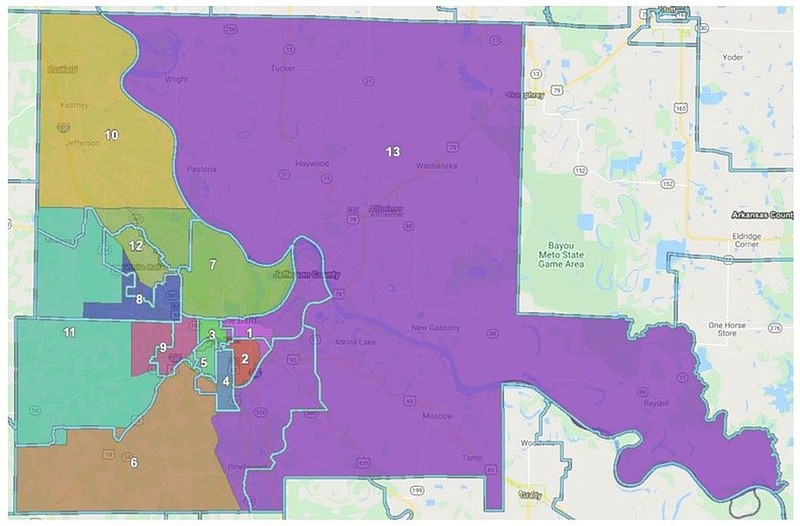
A change in population brought about many changes to the districts represented by each Jefferson County Justice of the Peace. Here is a breakdown of each district, along with the reason for change:
District 1 -- population decrease, area needed to increase.
• Lost portion that was northeast of Martha Mitchell Expressway (including Union Pacific Rail Yard) to District 13 to allow 13 to grow; follows existing precinct lines.
• West boundary with District 3 is changed to equalize populations and follow the school district zone.
• Gained the easternmost portion of District 2 in order to shift population out of 2 and keep similar areas together; follows existing precinct line.
District 2 -- population growth, area needed to decrease.
• Lost the northeast corner between drainage creek and interstate to District 1 to grow 1 and shed population; follows existing precinct line.
• Boundary with District 3 cleaned to be more compact and slightly shed population; now aligned with school district zone.
• Southern border cleaned to follow municipal boundary.
District 3 -- significant population decrease, area needed to increase.
• Shifted southwest to gain population from District 5 and allow District 1 to gain population.
• Southeast boundary with District 2 cleaned up to be more compact and follow school district zone.
• Several block swaps with District 2 and District 1 to equalize populations and follow school district zone.
District 4 -- significant population growth, area needed to decrease.
• Lost western portion to 6 (and 5) to make more compact and to shift population to 6 (and then to 13); now follows school district zone.
• Northern border is slightly shifted to equalize population and follow West 26th Avenue consistently.
District 5 -- population growth, area needed to decrease.
• Southern boundary is cleaned to follow Interstate 530.
• Gained a portion of District 9 in the southwest to improve the compactness of 9, shed population from 9, and to decrease precinct parts.
• Lost population in the north to District 3 (including gains from 9 mentioned above).
District 6 -- significant population growth, area needed to decrease.
• Northwest border with 11 cleaned up to follow Precinct and Township Boundaries and decrease precinct parts.
• Gained small portion in north that is southeast of South Camden Road from 9 to clean up a boundary and equalize population.
• Lost portion on other side of I-530 to clean up the boundary of 5 to follow interstate.
• Lost large portion of the northeast around the eastern boundary of Pine Bluff due to District 13 needing to gain substantial population.
• JP 6 incumbent location prevented the boundary from being cleaner and following roads; ended up following transmission line to prevent moving incumbent; huge census block (441 population) east of the incumbent was part of the problem.
District 7 -- population decrease, area needed to increase.
• Northern border moved north into District 10 to gain population from 10; aligned with Township border.
• Western border cleaned up to follow White Hall municipal boundary and then Arkansas 365.
District 8 -- minor population increase, area needed to decrease and also shift to account for changes to other districts.
• Gained the southwest portion of White Hall because District 12 had to shrink.
• Lost rural western portion of the district to 11 to even out gains from 12 and to allow 11 to grow; now follows White Hall School District boundary and is fully within the school district.
District 9 -- population increase, area needed to decrease.
• Lost blocks east of South Camden Road to District 5 in order to shed population and become more compact.
• Gained western "spiral" of Pine Bluff city limits along with rural blocks stretching out to township and school district zone lines. This allows for further annexations in this area that might cause awkward or small precinct slits in the future.
District 10 -- significant population increase, area needed to decrease.
• Southern boundary moved northward to align with Township and Precinct line in order to shed a large amount of population.
District 11 -- very significant population decrease, area needed to increase.
• Gained rural western portion of District 8 and the western portion of 12 and southwest portion of 10. Follows White Hall School District line and I-530.
• Lost northwest portion of Pine Bluff to District 9 to increase the compactness of 9 and facilitate potential western expansion on Pine Bluff without creating precinct parts. Follows township and precinct boundaries and Sulphur Springs Road/school district zone/precinct boundary.
• Southern border cleaned up to follow precinct and township boundaries.
District 12 --very significant population increase, area needed to decrease.
• South and western borders moved inward to follow Sheridan Road and I-530 in order to shed population.
• Northwest border continued northwest into District 10 to follow the corridor between I-530 and Arkansas 365 and township line to balance population while creating room for possible city expansion (without creating parts).
• Eastern border cleaned up to follow White Hall municipal boundary.
District 13 -- very substantial population decrease, area needed to increase.
• Gained a large portion of District 6 in the south and around the southern portion of Pine Bluff.
• Gained portion of District 1 that was northeast of Martha Mitchell Expressway (including Union Pacific Rail Yard); follows existing precinct and township lines.