A winter storm will bring periods of freezing rain to northern and west Central Arkansas Wednesday and Thursday, according to an update from the National Weather Service in North Little Rock late Tuesday afternoon.
There is a slight chance of a wintry mix of sleet and freezing rain in the forecast for Little Rock on Thursday night as the temperature drops to about 28 degrees, but the high Friday is projected to be 46 degrees.
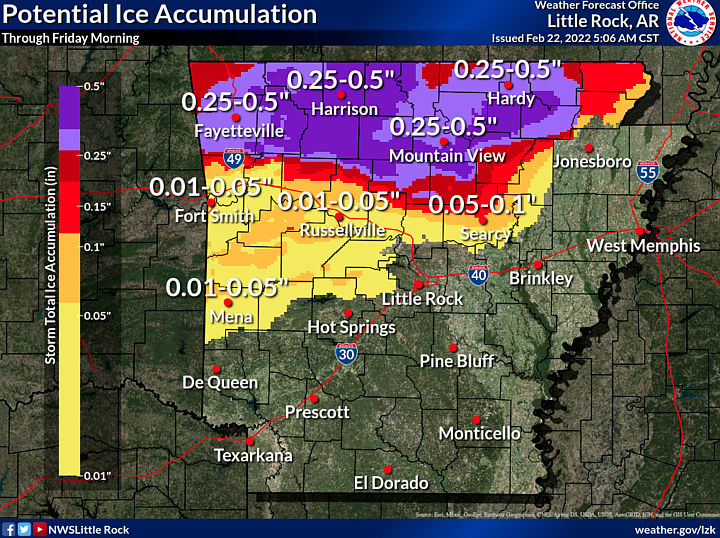
"Upwards of a half inch of ice could fall with higher amounts possible from north central to northeast Arkansas," the Weather Service said. "This amount of ice could lead to power outages and will definitely bring travel issues with it."
The agency's ice forecast map showed as much as 1 inch of ice accumulation in a swath stretching from Van Buren County northeast through Lawrence County.
Jeff Hood, a meteorologist with the National Weather Service in North Little Rock, said ice accumulation includes only freezing rain, not sleet or snow. Less than one inch of sleet and snow was in the forecast — all of it northwest of a diagonal line from just north of Mena to Mountain View to Hardy.
"As moisture returns to Arkansas on Wednesday, precipitation will overspread the state from southwest to northeast," according to update. "Precipitation will initially be sleet across western and northern Arkansas especially in the higher terrain areas such as the Ouachita and Ozark Mountains. Elsewhere, mostly a cold rain will be observed.
"From Wednesday evening into Thursday, precipitation will tend to be in the form of freezing rain across a large portion of northern into central Arkansas. This will likely be an extended period of ice accumulation which could cause significant concerns for elevated surfaces such as power lines and trees."
On Thursday, temperatures could briefly rebound, warming enough for freezing rain concerns to lessen with just a cold rain possible in some parts of the state, according to the Weather Service.
"As rain departs the state Thursday night, colder air will again surge southward which could lead to a brief period of light snow before precipitation comes to an end area-wide," according to the briefing.
— Bill Bowden
2:50 p.m.: High winds damage Randolph County buildings; chance for winter weather predicted for Wednesday
Several buildings in Randolph County were damaged by high winds around 4 a.m. today.
Bo Graham, director of the county's Office of Emergency Management, said straight-line winds blew the roofs off two homes in Maynard and one in Biggers.
"A couple we talked to said they were abruptly awoken with their roof being gone, so it was quite scary," said Graham.
He said a tree fell on another home.
Graham said the wind also blew part of the roof off a metal building in Pocahontas.
Graham said some power lines were down, but electricity was being restored to those homes.
He said there was also damage to carports and outbuildings.
— Bill Bowden
1:54 p.m. Strong winds cause damage, some outages across northern Arkansas, forecasters say; chance for winter weather predicted for Wednesday
The National Weather Service in North Little Rock received about 20 reports of wind damage early Tuesday, stretching from Russellville through northeast Arkansas.
Jeff Hood, a meteorologist with the National Weather Service, said most of the damage concerned downed trees but there was a report of roof damage to a barn near Hector and a small house near Pocahontas.
Hood said the damage was "indicative of damaging wind gusts" of 60 to 80 miles per hour.
"That's not to say there wasn't a brief tornado in there somewhere," he said.
Hood said the Weather Service has received reports of some power lines being down today because of tree damage.
At about noon today, Entergy Arkansas' outage map showed scattered power outages across the state, including 327 in Garland County, 284 in Pope County, 265 in Pulaski County and 210 in Randolph County.
Hood said damage was reported in the Russellville area around 3 a.m. and near Batesville at about 4 a.m. today as the storm front moved through Arkansas.
"The severe weather threat for Arkansas is almost all but gone," Hood said late this morning. "There may be a few thunderstorms this afternoon in eastern and southeast Arkansas. Very low threat across those portions of the state."
Hood said the storm front is ushering in cold air that will probably stick around for a few days. A wintry mix of freezing rain, sleet and snow is forecast for much of Arkansas on Wednesday.
"The greatest concern for the heaviest ice accumulation will be over areas of northern Arkansas," the Weather Service said in its morning briefing. "Localized amounts of one half inch or greater are possible with even higher amounts not out of the question in the higher terrain areas. This amount of ice could result in travel issues and power outages."
“One-eighth inch of freezing rain coating tree limbs and lines can begin to cause outages by breaking limbs hanging over power lines,” according to Entergy Arkansas, which provides electricity to about 722,000 customers in 63 Arkansas counties.
A half-inch accumulation of ice can add 500 pounds to power lines or tree limbs, which can break and fall onto people and property, according to the utility.
Winds can exacerbate the situation.
— Bill Bowden
11:13 a.m.: Arkansas storms to bring chance for flooding, hail and strong winds, forecasters say
Several storm systems are expected to bring further chances for severe weather across much of northeastern Arkansas on Tuesday, forecasters said, after strong winds overnight prompted reports of damage across the region.
The first system will move across the state Tuesday afternoon, bringing a slight to marginal risk for hail as large as a quarter, winds up to 60 mph and a very low chance for isolated tornadoes, the briefing states.
A flash flood watch remains in effect for parts of north Arkansas, according to a Tuesday morning briefing from the National Weather Service.
As much as 4 additional inches of rain could fall over the northeast corner of the state through Thursday night, while other areas are expected to get up to 2 inches, according to the briefing.
Portions of northern Arkansas may see flash flooding, as well as additional river flooding along the Black, Cache and lower White rivers, forecasters say.
Winter weather is possible in northern Arkansas from Wednesday through Friday as colder air moves in behind the cold front, forecasters say. The main concern as of Tuesday morning is freezing rain, leading to ice accumulation of greater than a quarter of an inch, with areas of higher terrain likely to see greater accumulation amounts, according to the briefing. Forecasters said a winter storm watch is in effect for much of north Arkansas through Thursday afternoon.
Jeff Hood, a meteorologist with the National Weather Service, said the storm front is ushering in cold air that will probably stick around for a few days. A wintry mix of freezing rain, sleet and snow is forecast for much of Arkansas on Wednesday.
"The greatest concern for the heaviest ice accumulation will be over areas of northern Arkansas," the Weather Service said in its morning briefing. "Localized amounts of one half inch or greater are possible with even higher amounts not out of the question in the higher terrain areas. This amount of ice could result in travel issues and power outages."
“One-eighth inch of freezing rain coating tree limbs and lines can begin to cause outages by breaking limbs hanging over power lines,” according to Entergy Arkansas, which provides electricity to about 722,000 customers in 63 Arkansas counties.
A half-inch accumulation of ice can add 500 pounds to power lines or tree limbs, which can break and fall onto people and property, according to the utility.
Winds can exacerbate the situation.
The National Weather Service in North Little Rock received about 20 reports of wind damage early Tuesday, stretching from Russellville through northeast Arkansas.
Hood said most of the damage concerned downed trees but there was a report of roof damage to a barn near Hector and a small house near Pocahontas.
The damage was "indicative of damaging wind gusts" of 60 to 80 miles per hour, according to Hood.
"That's not to say there wasn't a brief tornado in there somewhere," he said.
Hood said the Weather Service has received reports of some power lines being down today because of tree damage.
At about 1:30 p.m. Tuesday, Entergy Arkansas' outage map showed scattered power outages across the state, including 300 in Garland County, 339 in Pope County, 174 in Pulaski County and 104 in Randolph County.
Hood said damage was reported in the Russellville area around 3 a.m. and near Batesville at about 4 a.m. today as the storm front moved through Arkansas.
"The severe weather threat for Arkansas is almost all but gone," Hood said late this morning. "There may be a few thunderstorms this afternoon in eastern and southeast Arkansas. Very low threat across those portions of the state."
— Brianna Kwasnik