
All remaining departures from Clinton National Airport have been canceled Wednesday, according to a tweet from the airport. Some Wednesday arrivals are still scheduled, spokesman Shane Carter said.
Many Thursday morning flights have been canceled as well, Carter said. Flight statuses can be checked at clintonairport.com.
2:03 p.m.: Arkansas National Guard to assist state police in patrolling icy roadways
The city of North Little Rock will be providing a warming center at the North Little Rock Community Center, 2700 North Willow Street from 7 p.m. to 7 a.m. Masks are required and available. No pets are allowed, according to a news release from the city.
Eighty Arkansas National Guard soldiers and airmen will assist in patrolling state highways and interstates at the request of state police Wednesday through the Arkansas Division of Emergency Management.
National guardsmen will assist at Troop A in Little Rock, Troop B in Newport, Troop C in Jonesboro, Trop D in Forrest City, Troop H in Fort Smith, Troop I in Harrison, Troop J in Clarksville and Troop L in Lowell, until they are no longer needed, according to a news release Wednesday from the Arkansas National Guard.
Guardsmen will assist state police and offer assistance to motorists that become stranded, the release states.
Guardsmen will provide around-the-clock patrols working 12-hour shifts in their designated troop areas until weather improves and they are relieved, according to the release.
The guardsmen are permitted to help recover first responder emergency vehicles to a safe area, the release states. They are not permitted to recover privately owned or commercial vehicles.
- Brianna Kwasnik
12:14 p.m.: Highways in Northwest Arkansas, Ouachita Mountains covered in ice; sleet accumulating in Pulaski County
Highways throughout Northwest Arkansas and the Ouachita Mountains are covered with ice or patches of ice as a winter storm moves through the state, according to idrivearkansas.com.
"This is not a plowing event. It’s going to be primarily ice," the Arkansas Department of Transportation said on Twitter shortly before 10:30 a.m. "All 10 Districts are moving to 24 hour coverage."
At 9:30 a.m. today, the transportation department tweeted: "The line of winter precipitation is shifting slightly south. Central Arkansas is loading brine tankers and will start pre-treating major routes within the hour."
The forecast changed overnight, with Little Rock and other Central Arkansas cities now expecting as much as a half-inch of ice through Thursday.
At 10:20 a.m. today, the National Weather Service reported on Twitter that sleet was accumulating on elevated surfaces at its office in North Little Rock.
- Bill Bowden
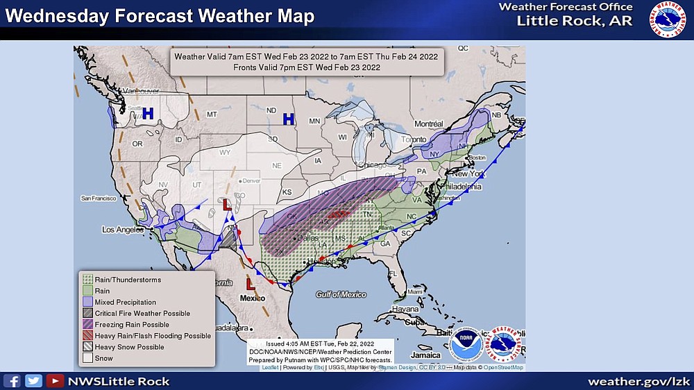
10:23 a.m.: Winter storm warning in effect for central, northern Arkansas; freezing rain predicted through Thursday
The National Weather Service has shifted its ice forecast farther to the south as a winter storm moves into Arkansas today.
"Widespread freezing rain is now expected Wednesday night and into Thursday," according to the forecast.
Little Rock is now included in the ice forecast, with one-quarter to one-half inch of ice expected through Thursday in the capital city, according to the National Weather Service in North Little Rock.
The new forecast calls for ice across almost the entire state of Arkansas, with only the southeast corner being spared.
Gallery: NWS winter weather briefing Feb. 23, 2022
[Gallery not showing above? Click here to see the briefing » arkansasonline.com/223nws]
"A quarter to half inch of ice is possible over northern Arkansas," the Weather Service said in its briefing this morning. "Localized amounts of up to an inch are possible from north central to northeast Arkansas. This amount of ice will likely lead to travel problems on area roadways. Power outages could also occur with this much ice accumulation on electrical lines."
The Weather Service said the computer models over the past 24 hours came in colder than expected, causing a shift in the forecast.
"The warnings and advisories have been shunted to the south to reflect this colder air," according to the Weather Service. "In addition, the heaviest axis of expected ice accumulation has also been shifted south a little bit."
- Bill Bowden
EARLIER: Winter storm will bring freezing rain to north Arkansas through Thursday
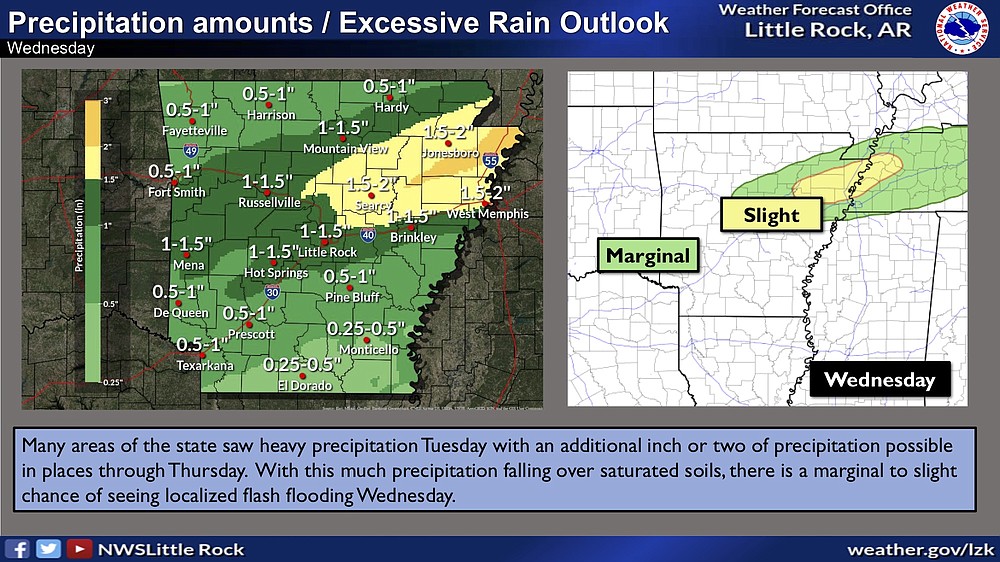
A winter storm will bring periods of freezing rain to northern and west central Arkansas today and Thursday, according to the National Weather Service in North Little Rock.
"Upwards of a half inch of ice could fall with higher amounts possible from north central to northeast Arkansas," the Weather Service said late Tuesday. "This amount of ice could lead to power outages and will definitely bring travel issues with it."
The agency's ice forecast map showed as much as 1 inch of ice accumulation in a swath stretching from Van Buren County northeast through Lawrence County.
A winter storm warning was issued for the northern one-third of Arkansas for today through Thursday. A winter weather advisory was in effect for many counties in central Arkansas and the Ouachita Mountains.
There was a slight chance of a wintry mix of sleet and freezing rain in the forecast for Little Rock on Thursday night as the temperature drops to about 28 degrees, but the high Friday is projected to be 46 degrees.
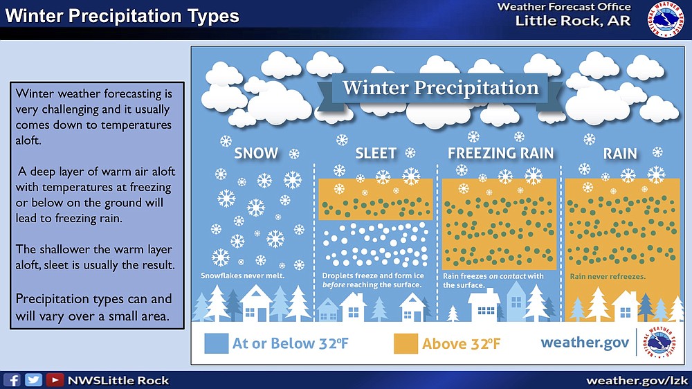
Jeff Hood, a meteorologist with the National Weather Service in North Little Rock, said ice accumulation includes only freezing rain, not sleet or snow. Less than one inch of sleet and snow was in the forecast -- all of it northwest of a diagonal line from just north of Mena to Mountain View to Hardy.
"As moisture returns to Arkansas on Wednesday, precipitation will overspread the state from southwest to northeast," according to the Weather Service. "Precipitation will initially be sleet across western and northern Arkansas especially in the higher terrain areas such as the Ouachita and Ozark Mountains. Elsewhere, mostly a cold rain will be observed."
From tonight into Thursday, the precipitation will tend to be in the form of freezing rain across a large portion of northern into central Arkansas, according to the Weather Service.
On Thursday, temperatures could briefly rebound, warming enough for freezing rain concerns to lessen, according to the Weather Service.
"As rain departs the state Thursday night, colder air will again surge southward which could lead to a brief period of light snow before precipitation comes to an end area-wide," according to the briefing.
Dave Parker, a spokesman for the Arkansas Department of Transportation, said the agency was busy Tuesday putting salt brine on highways in northern Arkansas.
"We're out today with the salt brine hitting all the A routs -- major highways and certainly all parts of I-49," said Parker. He said highways in the Harrison and Mountain Home areas were also being treated with brine.
Parker said brine wasn't being applied to highways in the Little Rock area because primarily rain was in the forecast for the capital city at that time, and rain would wash the brine off the roads. Parker said crews were prepared with salt in case the forecast changes and highways in the Little Rock area begin to ice over.
The first in a wave of winter storms passed through Arkansas early Tuesday morning, spawning wind gusts that ripped roofs from buildings and downed some trees.
The National Weather Service said it received about 20 reports of wind damage early Tuesday morning, stretching from Russellville through northeast Arkansas.
Hood said the damage was "indicative of damaging wind gusts" of 60 to 80 miles per hour.
"That's not to say there wasn't a brief tornado in there somewhere," he said.
Several buildings in Randolph County were damaged by high winds.
Bo Graham, director of the county's Office of Emergency Management, said straight-line winds blew the roofs off two homes in Maynard and one in Biggers.
"A couple we talked to said they were abruptly awoken with their roof being gone, so it was quite scary," said Graham.
He said a tree fell on another home.
Graham said the wind also blew part of the roof off a metal building in Pocahontas. He said there was also damage to carports and outbuildings.
Graham said some power lines were down, but electricity was being restored to those homes.
At 5 p.m. Tuesday, Entergy Arkansas' outage map showed scattered power outages across the state, including 393 in Pulaski County and 309 in Garland County.
Electric Cooperatives of Arkansas had 602 members without power as of late Tuesday afternoon.
Regarding the impending ice, Entergy Arkansas has said one-eighth inch of freezing rain coating tree limbs and lines can begin to cause outages by breaking limbs hanging over power lines.
A half-inch accumulation of ice can add 500 pounds to power lines or tree limbs, which can break and fall onto people and property, according to the utility, which provides electricity to about 722,000 customers in 63 Arkansas counties.
- Bill Bowden
Read more about winter weather in Arkansas
• Arkansas schools announce weather-related closures » arkansasonline.com/223clos/
• Take our winter safety quiz » arkansasonline.com/wintersafetyquiz/
• ARDOT winter weather map » idrivearkansas.com