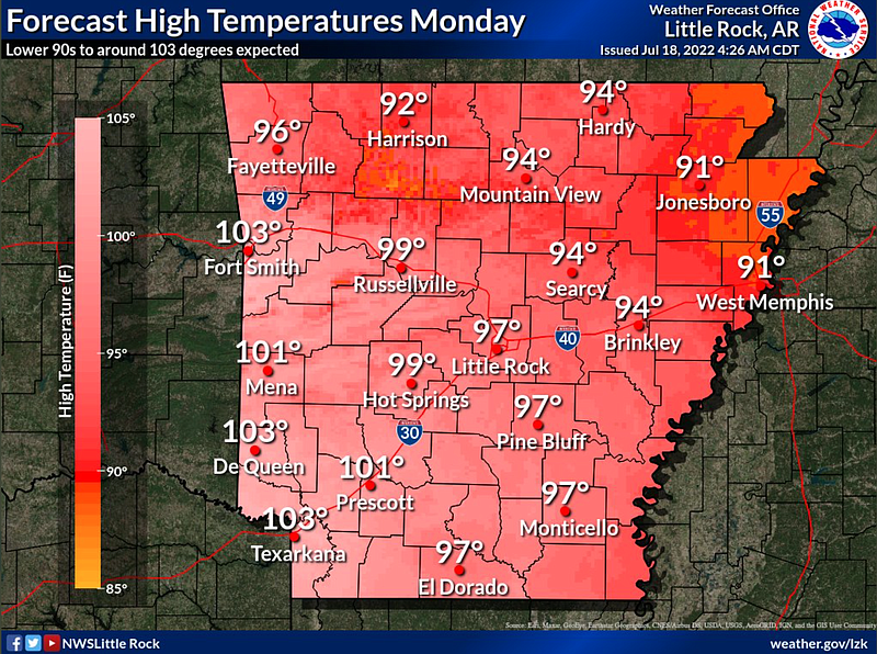
With temperatures in the 90s on Monday, highs are expected to be in or just under triple digits for Little Rock and much of the state for the rest of the week starting Tuesday, according to the National Weather Service.
Justin Condry, a meteorologist with the weather service in North Little Rock said after Tuesday the chance of rain is very low through the weekend.
Heat index values, how temperatures feel, are expected to be around 105 to 110 degrees over central and southern Arkansas, according to a tweet from the National Weather Service.
Most of the rainfall from the storms that rolled through the state overnight Sunday covered central and northern parts of Arkansas, according to Condry.
He said central parts of the state received half to three-quarters of an inch of rain while northeastern portions of the state received anywhere from half an inch to an inch of rainfall.
A tweet from the National Weather Service in North Little Rock stated that preliminary reports of rainfall showing areas around Jonesboro and Blytheville receiving the most rainfall.
Condry said there is a chance of some pop-up thunderstorms in southeastern parts of Arkansas for Monday afternoon.
“It kind of offsets yesterday, where they didn’t get anything,” said Condry.
The meteorologist said that the rainfall seen in northern parts of the state is not enough to remove the likely drought development conditions.
“It certainly helps,” said Condry, “But those locations are looked at on a monthly average. Most are still drier than usual.”
The storms from Sunday night to Monday morning left some Arkansans without power into Monday afternoon.
The National Weather Service office in North Little Rock received damage reports from several counties, including Logan, White, Independence and Pope, according to meteorologist Justin Condry.
“With the storms we received some reports of wind damage from straight line winds,” said Condry, “It was mainly power outages. We know Pulaski County and Arkansas County were also hit because of the Entergy outage map.”
Brandi Hinkle, a spokesperson for Entergy, said “Damages were caused primarily by wind and lightning, with the hardest hit areas being Central Arkansas, followed by the eastern portion of the state.”
The peak damage occurred around 3 a.m. and left 15,171 customers without electricity, said Hinkle. Hundreds were still without power as of Monday afternoon, according to the Entergy outage map.
Saline County alone was shown to have around 300 member-consumers without power as of Monday afternoon, according to an energy map from the Electric Cooperatives of Arkansas.