
MADISON COUNTY — Chasing waterfalls in the winter presents its own unique challenges, however the resounding scenic beauty you experience justifies the inconveniences. On a recent hike into Tea Kettle Falls, this proved especially true.
I read about the falls in Tim Ernst's "Arkansas Waterfalls" guidebook, and it has been on my to-do list for some time. When I saw NWA Hiking Meetup Group (meetup.com/nwahiking) had added it to the schedule for Feb. 27, I decided it was time to check it off the list.
Mother Nature had other plans, dropping a layer of freezing rain and several inches of snow just two days before the date of the planned hike. Doug McKinney, the organizer, waited until the evening before the hike to decide — after personally checking area road conditions — that the responsible thing to do was cancel the outing.
Bummer!
As I stood peering out the front window of my house, marveling at the beauty of the fresh snow blanketing the lawns and trees, I couldn't stop imagining what an adventure it would be to experience the Tea Kettle Falls in such conditions.
After phoning a few friends who had also signed up for the hike, we decided to meet at a convenience store just a few miles from the trailhead in the McIllroy Madison County Wildlife Management Area near Huntsville to give it the old college try.
THE OUTING IS ON
The trailhead for this Tea Kettle Falls hike is about 14 miles east of Eureka Springs off Arkansas 23. After adjusting the expected drive time for possible icy roads, we pulled out of the driveway just as the bright orange glow of the new day crested a distant ridge.
The first stretch of the drive was on interstate. Highway crews had already pushed the snow onto the shoulder, so this was clear sailing. By the time we exited the interstate onto two-lane highways, the warm sunlight had softened the remaining snow into mushy slush.
It wasn't until we pulled off Arkansas 23 onto a gravel road that conditions became a little dicey.
Gravel roads do not radiate heat the way asphalt does, making them the last roadways to thaw.
It had been the state of these final two miles of the drive that sealed McKinny's decision to cancel the organized hike. The afternoon before, he had found the road still buried under a solid layer of ice.
When I climbed out of my truck to test current conditions, the deep boot prints left behind told me the bright sun had begun softening up the ice and snow. Switching gears into four-wheel drive, we headed down the road, accepting the challenge of leaving "first tracks."
Slow and easy, we covered the remaining distance to reach the trailhead parking area and began our winter hiking adventure.
COLD TOES
A short walk from the parking area, the gravel road came to a fork with both directions closed to vehicles. Either road will lead hikers to Warm Fork Creek, but seeing a trail marker attached to the gate on the right branch, we chose it.
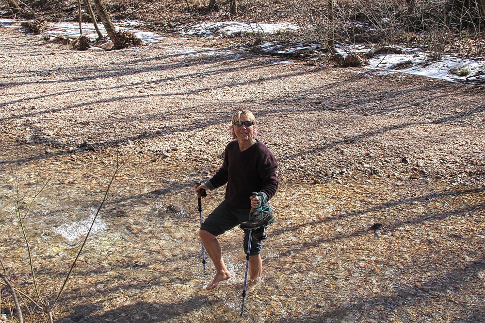
We followed the steep, abandoned roadbed down the hillside for about half a mile to reach the first of what turned out to be several creek crossings.
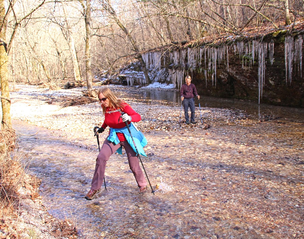
Temperatures still hovered around freezing. We knew the water would be cold, so we scouted both directions along the creek bank for a possible dry crossing. When none was found, our only option was to drop to the ground and begin pulling off our boots.
And yes, the water was cold, very cold.
Note to self: Add water shoes to winter hiking gear.
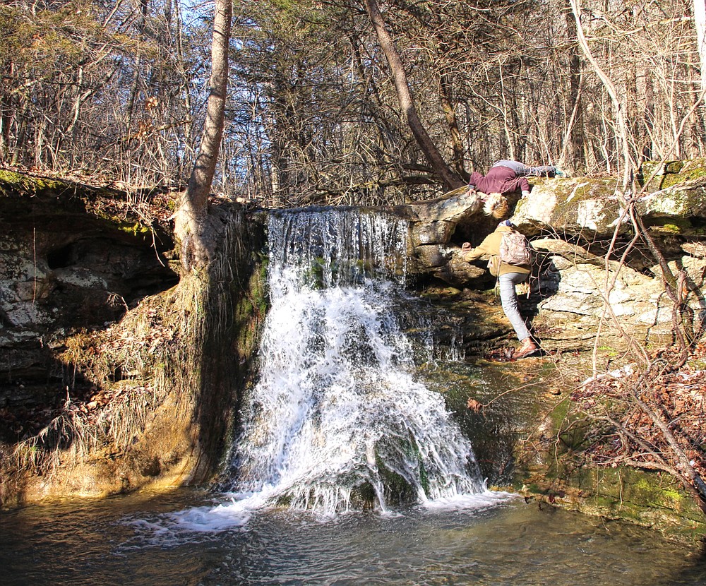
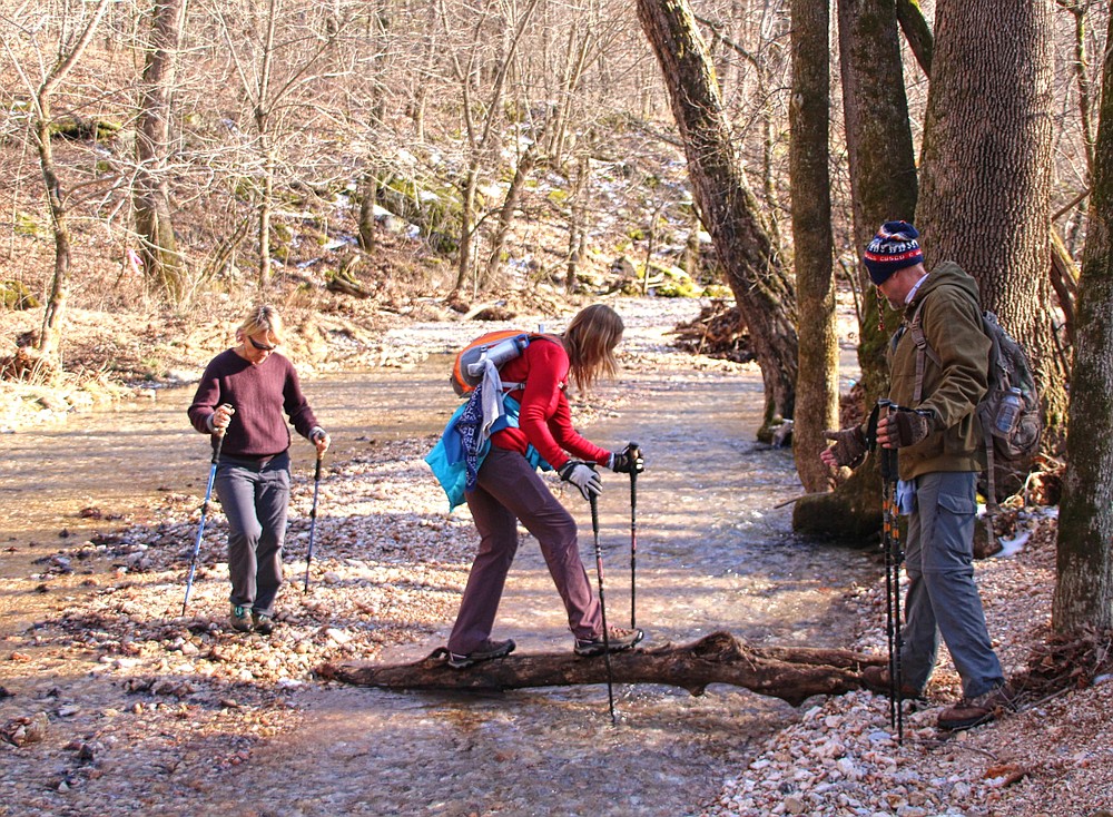
On the opposite shore, we decided to check out a "bonus" waterfall a couple of hundred yards upstream, and as it turned out, another water crossing. But we were able to take advantage of one of nature's bridges, a downed tree, for a much-appreciated dry crossing.
Reynolds Falls was flowing nicely. A 6-foot-wide curtain of water flowed over the edge of the cliff, then cascaded some 25 feet down additional rock ledges.
There was a large hole in the bluff to the right of the falls. We scrambled up to investigate and discovered the opening of a tunnel that ran behind the waterfall.
Very interesting.
When finished exploring Reynolds, we backtracked to our earlier crossing and continued our trek along the banks of Warm Fork Creek.
GLITTERING CURTAINS
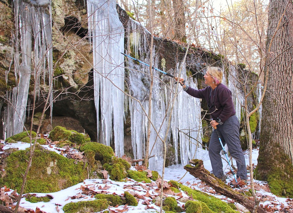
The walls of the hollow soon began closing in, with tall, rocky bluffs bordering each side. As we traveled deeper into the shadows of the hollow, the terraced bluff lines were adorned with row upon row of stunning, jagged crystal icicles. A tapestry of icicles decorated the canyon walls for as far as we could see.
This was just the beginning of our reward for leaving the comfort of a warm fireplace at home and braving the cold winter elements. We were walking into beauty, a winter wonderland.
On the taller bluffs, icy formations hung from the rock ledge to create crystal draperies, their sharply pointed fingers stretching ever downward toward the canyon floor. We encountered other areas where the icicles formed thick, solid columns that reached the ground. Each formation was a unique natural ice sculpture.
We also discovered several smaller waterfalls tumbling down small cavities that were cut into the hillside. One fall had a knotted, dreadlock-like bundle of roots dangling from the lip of the cliff that stretched all the way to the ground some 15 feet below.
As the stream meandered through the drainage, it flowed from one bluff to the other. Soon it wound its way back to the bank we were hiking, blocking our path as it ran head-on into the rock wall and forcing us once again to cross the stream.
The channel was wider at this point and shallower. Tossing rocks into the water, we used them as steppingstones across the stream, avoiding removing our boots. Yeah!
TEA KETTLE FALLS
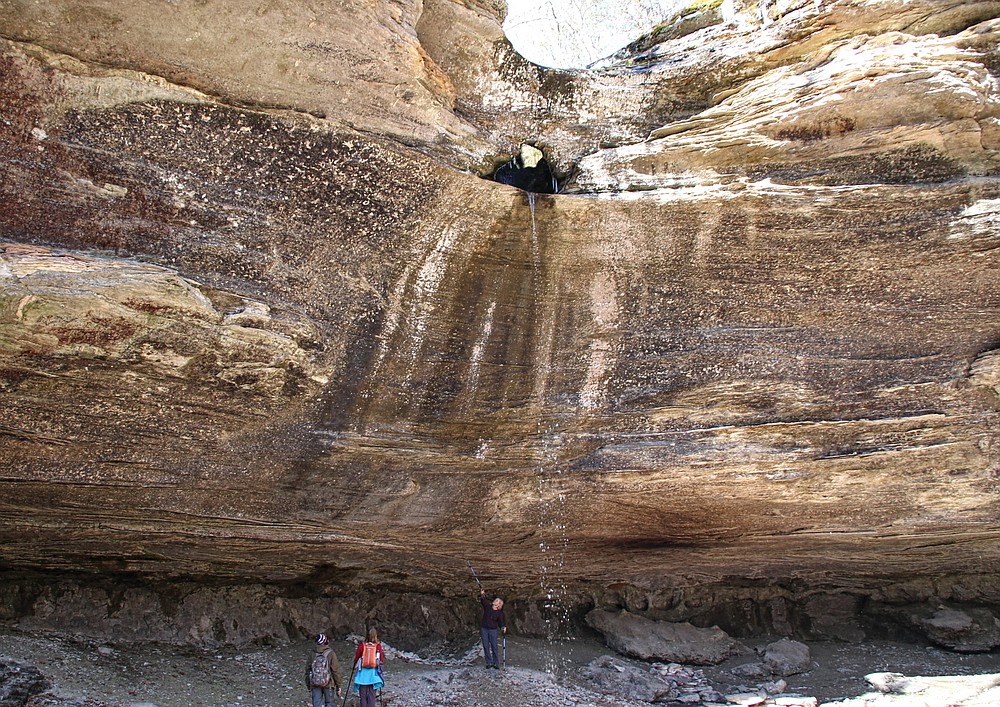
After a quarter of a mile of hiking through nature's ice chandelier — and two more creek crossings — we reached a small stream joining Warm Fork Creek's left bank. This was Kettle Creek. We followed the creek 100 yards to reach the base of Tea Kettle Falls.
The 60-foot-tall sheer bluff that wrapped around the opening of the mouth of the falls, with a deep cliff shelter cut into its base, was extraordinary on its own. Add to this the 46-foot free-fall of water pouring out of a large cavity burrowed through the side of the bluff, and it becomes an epic feature.
Impressive as this is from the base of the falls, you have to view it from the top to experience the true uniqueness of this natural creation. So, leave your hiking sticks and daypacks at the base of the bluff and prepare yourself for a little scrambling.
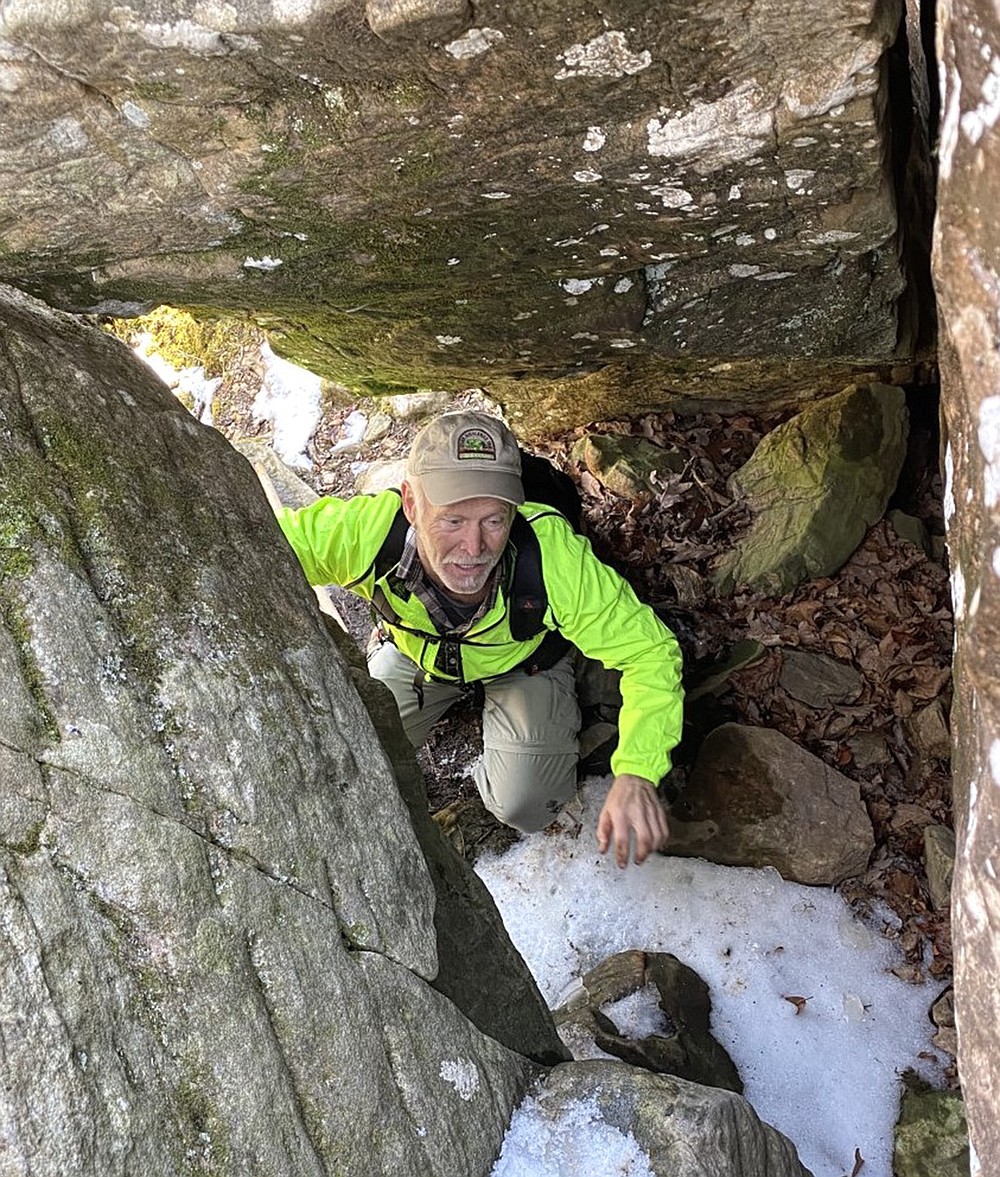
Follow the base of the rock bluff to the left of the falls until the hillside becomes sloped just enough that you can hike up. The incline will peter out at the base of several huge boulders, which appear to block your progress. Look closely, though, and you will notice that one of the boulders leaning against the bluff leaves just enough crawlspace for a person to squeeze through.
Once on the opposite side of the boulders, you discover a very doable scramble up the remaining bluff. This will take you atop the ridge with the waterfall.
Ernst once told me Tea Kettle was one of the most unusual waterfalls in the Natural State. As I peered into the 5-foot-wide cavity worn through solid rock, I understood.
From the top, Tea Kettle Falls resembles the more often visited Glory Hole Falls. However, unlike Glory Hole, Tea Kettle does not continue to bore a path straight down through the entire bluff and then pour into the shelter below. For some reason, the water flow here made an abrupt 90-degree turn, drilling a tunnel out of the face of the bluff wall. This shaft is considered the spout of the tea kettle.
From this view, the layers of rock in the hole, polished smooth by eons of swirling waters circling round and round, reminded me of thickly varnished hardwood. The lines between the rock layers resemble the annual rings of a tree.
This hike proved once again that you have to get out in all seasons to experience the natural wonders of the Natural State.
Note: Our entire hike was just over 4 miles, with about half of it spent bushwhacking along Warm Fork Creek. Hiking back up the old roadway was the only strenuous section. To witness a steady flow out of the spout of Tea Kettle Falls, you will probably need to visit it immediately after a good rain, if not during the rain. However, even a small stream of water makes it well worth a visit.
Bob Robinson of Fort Smith is the author of "Bicycling Guide to the Mississippi River Trail," "Bicycling Guide to Route 66" and "Bicycling Guide to the Lake Michigan Trail."
[Gallery not loading? Click here for more photos » arkansasonline.com/314falls/]