A third wave of winter weather, including freezing rain, is expected to hit parts of Arkansas Wednesday evening through Thursday morning, the National Weather Service said.
The Little Rock metro and Central Arkansas area are forecasted to see more freezing rain start around 5 or 6 p.m., according to Colby Pope, a meteorologist with the weather service in North Little Rock.
“Additional amounts of ice accumulation that Central Arkansas could see could be anywhere from a couple tenths of an inch to as much as half an inch,” Pope said Wednesday.
And freezing rain had started across southern and southeastern portions of Arkansas, as the final round of the ice storm ramped up, the weather service said in a tweet just before 12:45 p.m. on Wednesday.
“We expect this to continue and expand across much of the southern 2/3 of the state through tomorrow morning,” the tweet said.
Read more about what's expected in Northwest Arkansas and the River Valley here.
An earlier briefing from the National Weather Service said additional ice accumulation of a couple tenths of an inch or more is also possible in parts of western and eastern Arkansas.
Pope said the heavier freezing rain would be in central portions of the state, but some light winter precipitation might fall in some parts of northern Arkansas or southwest near the Pine Bluff and Sheridan area.
The meteorologist said that the freezing rain should switch over to regular rain just before noon on Thursday. “That will actually help melt the ice that’s accumulated from this third wave," he said.
Temperatures on Thursday afternoon are expected to reach the mid-30s, which will allow some of the ice to melt, Pope said.
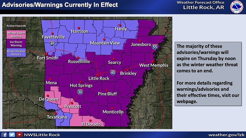
“We are approaching the end of this wild period of winter weather across the state,” the weather service said in a briefing on Wednesday.
According to the briefing, the ice storm warning, winter storm warning and winter weather advisories are expected to expire by noon on Thursday.
The briefing said dry conditions will be seen statewide by Friday morning, and temperatures are expected to be in the mid-30s to mid-40s Friday afternoon.
Pope said forecasts show temperatures in Little Rock to be in the 40s and close to the 50s on Saturday. Sunday could see temperatures in the upper 50s, he said.
During the first and second waves of winter weather, Pope said the Little Rock metro area received about 0.2 inches in freezing rain and anywhere between 0.2 and 0.4 inches of sleet.
“Yesterday, our saving grace was that what we thought would be freezing rain actually switched over to sleet,” Pope said. “Sleet is dangerous while it is coming down on the roads, but it won’t coat the trees and power lines like freezing rain would.”
The first two waves also brought around 1 to 2 inches of sleet to some northern parts of Central Arkansas and somewhere between 0.3 to 0.4 inches in the Mena to Little Rock to West Memphis area, the meteorologist said.
For more national coverage of the winter storm, click here.
POWER OUTAGES
Brandi Hinkle, a spokesperson for Entergy, said Wednesday that the electric company is prepared for a third wave.
“We’ve had people moved around to places we think are more likely to be hit with severe weather,” she said.
Hinkle said they are watching the winter weather move through south Arkansas and expect it to come to central parts of the state.
As of 3:37 p.m., Entergy had 2,310 reported outages across the state.
Of those, 919 were reported in the area of Hector in Pope County, but the utility reported that those outages had been resolved by 4:45 p.m. Wednesday.
By 6:50 p.m., there was an outage affecting 105 customers near Lake Dardanelle.
Entergy crews have restored around 16,000 power interruptions since Monday, Hinkle said.
“That accounts for being able to restore power temporarily and sometimes the electricity goes out again and we have to work to restore power another time,” Hinkle said.
The company said earlier Wednesday that the peak number of outages was the 7,600 seen Tuesday morning.
Beyond the extra weight from ice accumulation that can cause power lines to snap, the winter weather can cause power disruptions through “galloping,” an update from the utility said.
"Galloping occurs when rain freezes on the power lines, and then steady winds cause adjacent lines to move and sometimes contact one another,” the update said.
Another utility company, Arkansas Electric Cooperative, reported 1,050 customers without power at 4:50 p.m. Wednesday.
The outages included 202 with the Carroll Electric, 249 with C&L Electric and 428 with Ouachita Electric.
TRAVEL CONDITIONS
Several major highways in the northern and northwestern parts of the state were at least partially clear after the first two rounds of winter weather earlier this week, the map of road conditions ran by the Arkansas Department of Transportation showed just before 3 p.m. Wednesday.
Spokesperson Dave Parker confirmed mid-afternoon on Wednesday that one of the department's plow trucks crashed into a ditch earlier in the day while working in Newton County where Highway 16 and 21 meet. He said the driver was not injured.
In Little Rock, city roads were in "good condition" around 3 p.m. Wednesday, said Jon Honeywell, director of the Public Works Department.
The weather service in Little Rock tweeted at 2:21 p.m. Wednesday that travel could continue to be impacted until melting occurs Thursday morning.
For much of Wednesday, the transportation department spent the lull between the second and third waves trying to take advantage of what was "literally the calm before the storm."
"Our focus continues to be on I-40 and 65," Parker said. "One thing we've been doing today is spending time re-shifting salt supplies. Overall, the amount is fine. We're in good shape.
"But some of our smaller towns, rural areas are getting really low. So we're taking supply from the larger salt houses, domes, whatever you want to call it, and moving those to those areas. So that once this hits we're all equally and fairly [prepared]."
As for how the department's workforce was holding up, Parker said "Everyone's tired. I can tell you that.
"But we're fine numbers wise ... It's a hard 12-hour shift. When you're working 12 hours is one thing. When you're working out in the cold and you're operating that big equipment at night time and you gotta really focus, it mentally wears you down. You need that 12 hours of rest."
But, even after multiple days of winter weather, there likely won't be a significant impact on any highway construction or maintenance projects, he said.
"That's all contracted out," Parker said. "I'm sure it's slowed it down. But we build and they build into their contracts, into their bid, they build in a certain amount of winter weather days. Just like snow days, actually. They don't anticipate contractors doing as much work come January, February. It sort of slows down, and then it picks back up pretty, pretty fierce in March. So I don't think this is going to cause any problems."
No problems had been reported on the main runway or taxiways at the Clinton National Airport as of 4:30 a.m. Wednesday.
The airport remains open and operational, and no additional precipitation fell overnight, officials said.
The airport's airfield team has been on standby in case they are needed, according to a news release.
The airport said seven departing flights had been cancelled, with five delays, and eight arriving flights had been cancelled, with two delays.
The release suggested that passengers check their flight status before arriving, on the airport's website or their airline's website.
SHELTER OPEN
An emergency warming center operated by Aaron Reddin's The Van will be open for a third consecutive night at the Dunbar Community Center at 1001 W. 16th St.
Reddin said, "we've had a lot more folks come in than we anticipated."
The shelter initially saw 65 people on Monday night. By Wednesday morning, that number had risen to 110 people, who "packed on the gym floor," he said.
"The roads are pretty clear, so things haven't been too terrible," Reddin said. "We'll be open again tonight, so we'll have a good, hot supper tonight. Got volunteers whipping up breakfast burritos tonight for in the morning. We'll close sometime (Thursday)" after temperatures get above freezing.
On the menu for dinner Wednesday night was a "a hodgepodge of giant casseroles.
"[We'll] get everybody's belly full with a good hot meal tonight and go night-night," Reddin said.
For transportation to the shelter, call (501) 955-3444.
CLOSINGS
For the second consecutive day, Gov. Sarah Huckabee Sanders closed state office buildings except for critical operations on Wednesday because of poor road conditions in many areas of the state.
State employees who can telework should do so, and state agencies may implement liberal policies for their employees who cannot telework, her office said late Tuesday night in a news release.
State employees outside the affected areas should contact a supervisor for further instruction, according to the governor's office.
City of Little Rock facilities were also closed on Wednesday.
"Pending any additional adverse conditions from [Wednesday night's] forecasted weather, Little Rock Solid Waste plans to resume trash collections with a late start [Thursday] morning. We will plan to begin with Tuesday routes and work as quickly as possible to catch up to the normal schedule," Honeywell, the city's public works director, said.
The city had suspended trash pickup over the previous two days due to the weather.
The Clinton Presidential Center, including 42 bar and table and the Clinton Museum Store, and the Little Rock Zoo will be closed Thursday.
The Saline County Courthouse and all county offices will be closed Thursday.
Little Rock, North Little Rock, Pulaski County Special, Cabot and Gentry school districts will have their students learning remotely again on Thursday.
University of Arkansas - Pulaski Technical College locations will be closed Thursday.
All in-person day and evening classes are cancelled, though online and hybrid courses may continue to meet at the discretion of instructors. Classes that usually meet on campus may also shift online at the discretion of the instructors, the school said.
A free CPR and automated external defibrillator training that was scheduled for Wednesday in Conway has been postponed.
The training, offered by the University of Central Arkansas, Conway Fire Department and Conway Regional Health System, is now set for 6-8 p.m. March 1 at the Prince Center on the UCA campus.
Watson Chapel School District will be closed again on Thursday, with students learning remotely instead. Read more about the weather in the Pine Bluff area here.
Arkansas State University in Jonesboro has canceled all on-campus classes, and academic and business offices will remain closed on Thursday.
The student union will be open from 8 a.m.-8 p.m. and the dining hall will be open for brunch hours. The Dean B. Ellis Library will be open from noon until 7 p.m. with limited staff. The Red W.O.L.F. Center will also open limited hours, from 10 a.m. until 6 p.m.
The Red Wolves' Sun Belt Conference men’s basketball game with South Alabama will tip off at First National Bank Arena at 7 p.m. Thursday, the university announced Wednesday afternoon.
Also, both of the University of Arkansas Hope-Texarkana's campuses were closed on Wednesday.
EARLIER: Ice storm warning continues for much of Arkansas
Several major highways in northern and Central Arkansas were at least partially covered with ice on Wednesday morning as an ice storm warning continues for much of the state, a winter weather map from the Arkansas Department of Transportation showed.
Interstate 40’s westbound on-ramp near the Dr. Martin Luther King Jr. exit in West Memphis remained blocked due to a towing/recovery operation, a tweet from IDrive Arkansas said shortly after 10 a.m.
Some highways near Little Rock and Pine Bluff were covered in slush, the map indicated.
Roughly 1,200 customers served by the Electric Cooperatives of Arkansas were without power Wednesday morning just before 10:15 a.m.
Lincoln County had over 700 customers without power and over 500 people in Cleveland County were facing outage, the map showed.
Entergy showed that just under 1,000 customers were out of power around 10:15 a.m., according to the electric company’s outage map.
Calhoun, Mississippi, Crittenden and St. Francis Counties were among those most affected, with each county shown to have over a 100 customers without power, the map indicated.
For the second consecutive day, Gov. Sarah Huckabee Sanders has closed state office buildings except for critical operations Wednesday because of poor road conditions in many areas of the state.
State employees who can telework should do so and state agencies may implement liberal policies for their employees who cannot telework, her office said late Tuesday night in a news release.
State employees outside the affected areas should contact a supervisor for further instruction, according to the governor's office.
Pulaski County announced Wednesday morning that county offices would be closed due to the inclement weather.
The second wave of an icy weather system that began rolling across the state on Monday arrived in central Arkansas "right on cue" at high noon on Tuesday.
Dave Parker, spokesman for the Arkansas Department of Transportation, was in west Little Rock doing a live shot for the Weather Channel when it reared its head.
"It's fantastic out here," Parker said around 12:30, the sarcasm in his voice as heavy as the ice accumulating outside. "I got caught in the sleet storm. It started sleeting and pelting and then now it's a mess."
With the ice storm in full swing, Parker said he would be "hunkered down doing live shots from my driveway."
Rapidly alternating bands of sleet and freezing rain passed through the state on Tuesday before drifting off to the northeast later in the day, said meteorologist Thomas Jones with the National Weather Service in North Little Rock.
Another wave of wintry precipitation over Texas was expected to be headed into the state Wednesday after a night of freezing drizzle, which freezes more efficiently than larger droplets, Jones said.
Wednesday was expected to bring more freezing rain than sleet, which when combined with lower-than-predicted temperatures was likely to worsen the ice accumulation, Jones said.
"Our temperatures may not rebound as much on Wednesday as we were hoping," Jones said.
An 11 a.m. tweet on Tuesday from the forecasting agency predicted "a rough 24 hours" for central and southern Arkansas, with travel nearly impossible in parts of the state from Tuesday afternoon overnight into Wednesday.
From Little Rock northward, Jones said he expected the built-up ice on power lines and tree branches to contribute to power outages.
Around 3:45 p.m. Tuesday, the weather service extended the ice storm warning through noon Thursday.
Fortunately, Thursday was predicted to bring temperatures in the 40s and rain that was likely to wash ice from power lines, Jones said.
"This isn't something that's gonna hang around once it's over," Jones said.
Monday's sleet was concentrated in the northern parts of the state, Jones said, with some areas getting from a quarter of an inch to 1 inch of sleet. That will have a lot bigger impact than a similar accumulation of snow, he said.
"An inch of sleet is a lot of sleet," Jones said.
Gov. Sarah Huckabee Sanders issued an executive order Tuesday, declaring a state of emergency due to the winter weather.
Sanders' order removes regulations on commercial transportation hauling consumer goods or power transmission equipment for the next 30 days.
In her order, she noted the likelihood of downed power lines.
The order also suspends some procedures of the State Office of Purchasing and other offices to help provide the most aid possible to the Arkansas Department of Energy and Environment and the state Department of Public Safety though the Arkansas Division of Emergency Management.
The order shall be in effect "until such time as the emergency conditions cease to exist," the order reads.
ROAD CONDITIONS
Several highways in Central Arkansas were coated with slush as of 2 p.m. Tuesday, according to the winter weather map on idrivearkansas.com.
Interstate 40 was covered with ice and ice patches. The westbound left lane of Interstate 40 near exit 142 had been cleared, the state Department of Transportation said just before 2:30 p.m. It had previously been blocked due to an accident.
Jon Honeywell, director of Little Rock's Public Works Department, called conditions of the nine primary roadways in the city a "mixed bag" but said that they hadn't seen a spot that was worse than others.
Crews will continue working in 12-hour shifts -- 75 people on the day shift and 50 at night -- to treat streets with a sand and salt mix.
Honeywell said the work would likely last through Thursday morning.
"[We'll] keep plugging away at it until it stops either material coming down or we're able to get it off the streets and people can get around," he said. "We've done this over the last few years. It seems like we've done it a lot.
"So we've gotten a little better, a little more organized, a little more experience added, unfortunately, I guess you could say."
Pulaski County Judge Barry Hyde said the county is dealing with the challenges an ice storm can bring.
"Our folks are as prepared as they can be," he said. "Just ice is the hardest thing because you can't plow it. We try to concentrate on the main roads, the stop signs and the hills."
But, whatever happens, Hyde said, the county will take it as it comes.
"It is what it is," he said Tuesday afternoon. "Our folks will be working all through the next 24 hours trying to keep things as safe as possible."
In the southern third of the state, most highways were clear as of 2:10 p.m., the Department of Transportation's map showed.
U.S. 67 was completely blocked after several crashes, according to the Arkansas Department of Transportation map.
And some of the major highways in southeast Arkansas are partially covered with ice, slush and ice patches, according to the map.
Parker said it had been "all hands on deck" at the Department of Transportation for the previous 24 hours, with "all 10 districts reporting."
"We're obviously focusing on the interstates or primary roads, trying to keep I-40 and 55 (clear)," Parker said, the sound of ice pelting the top of his car loud enough to be heard over the phone. "The predicted ice storm almost follows perfectly the pattern of I-40."
One video posted to Twitter by storm chaser Jordan Hall late Tuesday morning showed traffic backed up for 15 miles on I-40 near Jennette, roughly 20 miles from Memphis, due to a wreck. It also showed power lines covered in ice.
"Our guys out there are now armed in some cases with chainsaws because we've got to clear the roadway," Parker said.
"The main area of concern for the heaviest ice accumulation stretches from near Mena eastward across central into eastern Arkansas," a briefing from the weather service said Tuesday morning.
A tweet from the weather service said that the ice is expected to make "traffic difficult to near impossible" as well as increase the potential for power outages and smaller trees or larger limbs falling.
While the ice made ground travel difficult, it was no picnic in the air, either.
By 3 p.m., Bill and Hillary Clinton National Airport/Adams Field had seen 11 arriving flights canceled with six delays and eight departure cancellations with six delays.
The departing cancellations were primarily destined for the Dallas-Fort Worth area, along with Houston, Denver, Atlanta and St. Louis.
Shane Carter, the airport spokesman, said the condition of the airfield was "slushy" and that a crew of 25 people were on duty to tend to it.
"Our airfield team has been using a broom to try and keep everything just as dry as possible and they'll continue working through the duration of the event," Carter said. "They will be taking breaks and then coming back to work later (Tuesday) evening. ... Then they'll be working also tomorrow. We have several that will be staying the night again in hotels. We have 15 hotel rooms that 15 people will be using tonight. And once the employees get to the airport, we cook and provide everything that they need in order to be comfortable."
Carter said in his 11 years working at the airport, it had only been closed due to weather twice.
POWER OUTAGES
According to Entergy spokesperson Brandi Hinkle, the utility saw a power outage peak of 7,500 customers across the state at about 4:30 a.m. Monday. By 9:45 a.m. Tuesday, the company's outage map showed that that number was down to around 4,000 customers in the state, including roughly 2,500 customers in Mississippi County and 450 customers in Pulaski County.
By 5 p.m., only about 1,600 customers were without power in the state, and 53 in the Little Rock area.
"...We know additional precipitation is likely and could cause more outages in the next 24-36 hours," Hinkle said.
In addition, the Electric Cooperatives of Arkansas outage map showed that over 150 customers were without power as of Tuesday morning, with over half of the outages being located in the Woodruff, Cross and St. Francis area.
SCHOOL PLANS
The school districts in Little Rock, North Little Rock, Pulaski County Special, Cabot, and Watson Chapel announced they will again utilize remote learning Wednesday.
All after-school athletic events and extracurricular activities are canceled or rescheduled for Little Rock and PCSSD schools. Afterschool CARE, as well as administrative offices, will remain closed, the Little Rock district said in a news release.
Russellville schools will be closed Wednesday and the day will be made up on April 7, the district announced in a news release.
Searcy School District also announced it would be closed.
University of Arkansas-Pulaski Technical College will be closed Wednesday. In-person classes are cancelled, but online and hybrid courses may continue to meet at the discretion of the instructor, the school said.
Arkansas State University in Jonesboro has canceled all on-campus classes, and academic and business offices will remain closed.
The student union will be open from 8 a.m.-8 p.m. and the dining hall will be open for brunch hours.
Arkansas Tech University campuses in Russellville and Ozark, as well as Arkansas Tech Career Center, will be closed. All classes will pivot to online learning, and essential services will be available virtually, the school system said.
Southern Arkansas University in Magnolia will also be closed Wednesday.
Information for this report was provided by Dale Ellis and Michael R. Wickline of the Arkansas Democrat-Gazette.