A wind advisory was expanded Tuesday morning, to cover the entire state on, forecasters with the National Weather Service said.
The storms moving through Arkansas on Tuesday are expected to bring strong winds, the weather service in North Little Rock said in a briefing.
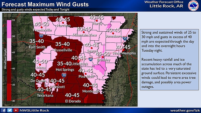
Strong winds with speeds of 25 to 35 mph are possible, along with with gusts of up to 40 mph, the briefing said Tuesday.
Due to recent rainfall, the winds could be even more dangerous, as the ground is saturated from recent rainfall, meteorologists said.
“Persistent excessive winds could lead to more area tree damage, and possibly area power outages” the briefing said.
“Just because there is no foliage doesn’t mean the wet soil can’t contribute to a tree falling, especially with those strong winds,” Jeff Hood, a meteorologist with the weather service in North Little Rock, said on Monday.
The forecaster also said Arkansans in the southern third and east portions of the state should be mindful of tree limbs that were broken by the ice but have yet to fall.
“These winds could knock a lot of those limbs down and could be dangerous as well,” Hood said.
The Hot Springs Fire Department issued a one-day burn ban for Tuesday due to the expected wind. The Tuesday ban took effect at sunset on Monday, according to a news release.
Another storm is expected to enter the state on Wednesday afternoon and bring severe weather overnight, the briefing said.
All but some parts of northern Arkansas are at a slight risk for severe weather on Wednesday, forecasters said.
The weather service defines a slight risk as there being “an increased confidence that that some storms will contain damaging winds, severe hail, and/or tornado potential,” according to the briefing. Isolated to scattered severe storms are expected with this risk.
“We are considering all types of severe weather possible at this point, including hail, wind and tornadoes,” Hood said on Monday.
There might be locally heavy rainfall but a widespread significant amount is not currently expected. However, areas already struggling with flooding could see more of a challenge due to the rain, the forecaster said.
“We are beginning to get to that time of year where we have strong or severe storms in the forecast back to back more often than not” Hood said, “and we just want people to be aware.”