Some thunderstorms in parts of Arkansas could create tornadoes, hail and strong winds on Wednesday, the National Weather Service said.
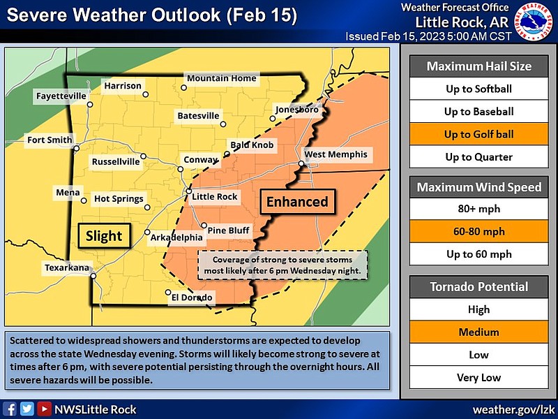
Southeastern and eastern parts of Arkansas are now at an enhanced risk of seeing severe weather Wednesday evening and overnight, the weather service said.
An enhanced risk of severe weather is defined as a storm that “will produce very large hail, damaging winds, and/or tornadoes,” according to a tweet. These are intense storms that an area may experience only once or twice a year.
Jeff Hood, a meteorologist with weather service in North Little Rock, said the enhanced risk also means the storms will be more widespread or long-lasting in those areas.
“As the system approached, we did notice a greater potential for tornadoes and other types of severe weather,” Hood said Wednesday.
Winds could be as strong as 60 mph, and hail could be as big as a golf ball, a briefing from the National Weather Service said.
Most of the rest of the state is at a slight risk for severe weather, the briefing said.
A slight risk is defined as there being “an increased confidence that some storms will contain damaging winds, severe hail, and/or tornado potential,” according to the briefing. Isolated to scattered severe storms are expected with this risk.
The storms could start in southern parts of the state as early as 5 or 6 p.m., Hood said. Before then, Wednesday is expected to be dry and unaffected by severe weather.
“Then some other storms from northeast Texas and southeast Oklahoma will move towards the state and enter into parts of western Arkansas around 7 or 8 p.m.,” Hood said.
The storms will move in and really kick up overnight, the forecaster said.
In Little Rock, Hood said thunderstorms will start in the area between 6 and 9 p.m.
“Little Rock is close enough to be on the edge of that enhanced risk area [where] all the potential threats of tornadoes, hail and strong winds are possible,” Hood said.
The meteorologist said he recommended that Arkansans have a plan before they go to bed, so that, if they wake up to a severe weather alert, they know what to do.
“You don’t want to waste time scrambling to figure out a plan and then do it; plan today when it is dry, and then tonight you’ll know exactly what to do if you get an alert,” Hood said.