All of south Arkansas and much of east Arkansas were under a tornado watch Friday evening, but the threat was expected to move out of the state by 9 p.m., said John Lewis, senior forecaster for the National Weather Service in North Little Rock.
At 1:30 p.m. Friday, the Weather Service's Storm Prediction Center in Norman, Okla., had issued a tornado watch for southwest Arkansas until 7 p.m. Friday, with tornadoes and large hail possible.
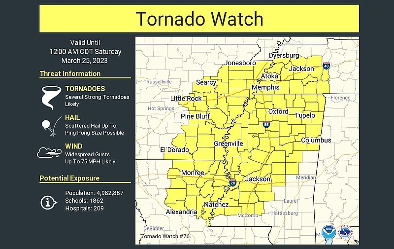
Late Friday afternoon, the Weather Service issued a tornado watch for much of east Arkansas, from El Dorado through Little Rock to Jonesboro, east to the Mississippi River.
Lewis said storms on Friday mainly brought heavy rain. Some flash flooding occurred in Polk, Scott and Logan counties. Lewis said some areas received 3 to 4 inches of rain over the previous 24 hours.
"Much of the northern half of Arkansas has received 1 to more than 2 inches of rain," the Weather Service posted on Twitter Friday afternoon. The tweet said the heaviest totals were noted in Fort Smith and Waldron to Russellville and Clinton, as well as in Northwest Arkansas' Benton County.
The Weather Service's local hydrology chart showed moderate flooding predicted for Saturday morning along the White River at Des Arc and the Spring River at Hardy and Imboden. By Sunday morning, moderate flooding is also expected along the Black River at Black Rock.
Lewis said Friday's rain added to the state's already swollen rivers.
"The ground is very saturated," he said. "It's very wet out there. As long as it keeps raining, the river's aren't going anywhere. They're going to stay up."
Lewis said "it'll be much quieter" on Saturday, with forecasters predicting mild conditions with high temperatures in the 70s for central Arkansas.
— Bill Bowden
3:41 p.m.: Tornado watch issued for southwest Arkansas as severe storms hit much of the state
The National Weather Service has issued a tornado watch for southwest Arkansas until 7 p.m. Friday.
According to the Weather Service's Storm Prediction Center in Norman, Okla., a few tornadoes are possible as well as scattered large hail and isolated very large hail measuring up to 2 inches in diameter.
Damaging wind gusts to 65 mph are also possible, according to the storm center.
Besides southwest Arkansas, the tornado watch includes northeast Texas, northwest Louisiana and a small section of far southeast Oklahoma.
"Storms are expected to intensify near and ahead of a cold front across the ArkLaTex region, with additional and somewhat more isolated storms possible by late afternoon," according to the storm center. "Overall severe potential including tornado risk is expected to increase as storms progress east-northeastward through late afternoon/early evening.”
— Bill Bowden
12:01 p.m.: Chance of damaging winds, hail and tornadoes for much of Arkansas on Friday, forecasters say
Severe storms capable of producing damaging winds, hail and tornadoes are expected across Arkansas on Friday, the National Weather Service said.
“Showers and storms this morning will quickly intensify as the day progresses with all modes of severe weather possible including tornadoes,” the weather service said in a tweet Friday morning.
Central and eastern parts of the state have the greatest chance to see severe storms, a briefing from the weather service in North Little Rock said.
Storms on Friday could produce quarter-sized hail, damaging winds as strong as 80 mph and a medium potential for tornadoes, forecasters said.
Much of southeastern Arkansas is under a moderate risk for severe weather. The weather service says a moderate risk means that widespread severe storms are likely.
Little Rock, along with parts of central, northeastern and southeastern, is at an enhanced risk to see severe weather. An enhanced risk means that numerous severe storms are possible, according to the weather briefing.
Dennis Cavanaugh, a forecaster with the weather service in North Little Rock, said that cold air has set a boundary south of the Little Rock metro area.
“Unless that boundary moves back north, it will minimize a lot of the potential for severe weather and tornadoes in the metro area,” he said Friday morning.
Southeast Arkansas remains the greatest concern for severe storms as it is south of this boundary, Cavanaugh said.
Flooding is a concern as more widespread rain is expected on Friday, the briefing said. Flood watches across northern and Central Arkansas are in effect until early Saturday.
Parts of central, northeastern and western Arkansas could receive up to three more inches of rain on Friday, the briefing said. Northwestern Arkansas could see up to an inch and a half of rainfall while much of southern Arkansas is only expected to see up to an inch.
“With the ground saturated in many areas, the water simply has no place to go,” the briefing said, “As such, there is a slight to moderate chance of seeing flash flooding.”
Cavanaugh said people driving, especially in central Arkansas, should be mindful driving as the rain has not let up in the area.
“Water always looks flat on roads, no matter what, so we never suggest driving on covered roads,” the forecaster said.
The meteorologist also said the weather was an evolving situation.
“It is changing so make sure you have multiple ways you can get weather warnings,” Cavanaugh said, “At any time any one way of communication can fail due to severe weather so it is important to have another way to get that information.”
— Remington Miller