LITTLE ROCK — Each day, dozens of Arkansas City residents walk the few blocks from downtown to the levee.
Some go first thing in the morning. Others head there during the noon hour.
“If I’m gonna be washed away, I want to know about it,” explained Ann Wood, who works at the post office.
Keeping an eye on stressed levees was the primary focus Tuesday from the southeast Arkansas town to Natchez, Miss., to the riverine areas of southeast Louisiana.
Thus far, the big flood of 2011 hasn’t defeated a complex system involving busy ports, long-unused spillways and levees never put to this kind of test, according to the U.S. Army Corps of Engineers.
Galleries & Videos:
Recent flood stories & info:
“The system we have now carries a lot more water than back in ’27. We’ve made all the cut-throughs, and it’s deeper. The levees are much bigger,” said Sam Angel of Lake Village, a senior member of the Mississippi River Commission.
Still, it’s widely acknowledged that it will be difficult to continue to hold back such vast amounts of water in the weeks to come.
The Mississippi River crested Monday at Arkansas City, a town of about 600 people. It reached 53.14 feet, several feet lower than the 1927 record of 59.20.
But recollections of the Great Flood of 1927 are enmeshed in the former port city’s history.
In April of that year, floodwaters from the Arkansas River smashed through the levee at Pendleton. And on the other side of Arkansas City, the Mississippi River changed its course, jumping from one side of a barrier island to another and landlocking the town.
Without its river-driven commerce, Arkansas City foundered.
Shops along Front Street vanished. Families moved. The city’s population - about 15,000 - shrank
Now, 84 years later, as Old Man River grumbles and strains against its levee, the city’s residents keep a wary watch. It will be weeks before the floodwaters recede.
A collective, in-drawn breath hovers over the town as those who gather at Arkansas City Grocery wonder aloud each day:
Will the levee hold?
MISSISSIPPI
Downriver, at Natchez, Miss., the U.S. Coast Guard briefly halted barge traffic Tuesday on one of the nation’s main shipping arteries for fear that the vessels’ wakes could harm a levee system that protects thousands of people.
Late Tuesday, however, the Coast Guard reopened the 15-mile section with “tight” traffic controls after sand erosion first thought to have been caused by the wakes was found to be caused by an underground pipe, said Capt. Michael Gardiner, the captain of the port for the lower Mississippi River sector.
Only one vessel at time was being allowed through at Natchez late Tuesday, and Gardiner cautioned that the segment probably will close again if the river rises to 62.5 feet there, which is likely.
On Tuesday, the river had risen to 61.7 feet at Natchez and was expected to continue rising to a crest of 63 feet Saturday, said Jim Fairly, a meteorologist with the National Weather Service in Jackson, Miss. Flood stage at Natchez is 48 feet.
“Natchez Under the Hill, they’re ... holding out a world of water,” the Mississippi River Commission’s Angel said about a section of that city.
Elsewhere in Mississippi, backwater flooding along the Yazoo River remained the largest concern.
“A lot of water covering lots of farmland and a lot of roads blocked,” said Marty Pope, senior hydrologist at the weather service in Jackson.
While revised forecasts showed that the area shouldn’t see record-setting levels, more people continued to flee their homes.
More than 4,900 people in 17 counties had left their homes as of Tuesday, up from 4,200 the day before, said Jeff Rent, a spokesman for the Mississippi Emergency Management Agency.
At Vicksburg, water continued its rise to 57 feet Tuesday afternoon, above the 1927 record of 56.2 feet. Its crest at 57.5 feet is not expected until Thursday, Fairly said.
At Greenville, the Mississippi River crested at 64.2 feet Tuesday, nearly a foot below the record 65.4 feet set in 1927 and more than 16 feet above flood stage.
Despite the crests, water levels won’t start falling for several days, Pope said.
“You’ve got so much water that’s stored in the White River system and even to lower parts of Arkansas - a lot of that water’s backed up in there waiting. ... As soon as it drops a little bit, that water will just come in behind it,” Pope said.
ARKANSAS
Tuesday’s river closing at Natchez added to the worries of many Arkansas wheat farmers who have already had a difficult year, the University of Arkansas Extension Service said in a release Tuesday.
Wheat growers have hadproblems with flooded fields, hail and ice, and now are concerned about how they will ship their harvests if the river doesn’t open soon.
The Mississippi is the gateway for nearly 60 percent of all U.S. exported wheat, corn and soybeans.
“There are some concerns about where the wheat is going to go,” Jason Kelley, wheat and small-grains specialist for the University of Arkansas Agriculture Division, said in the news release.
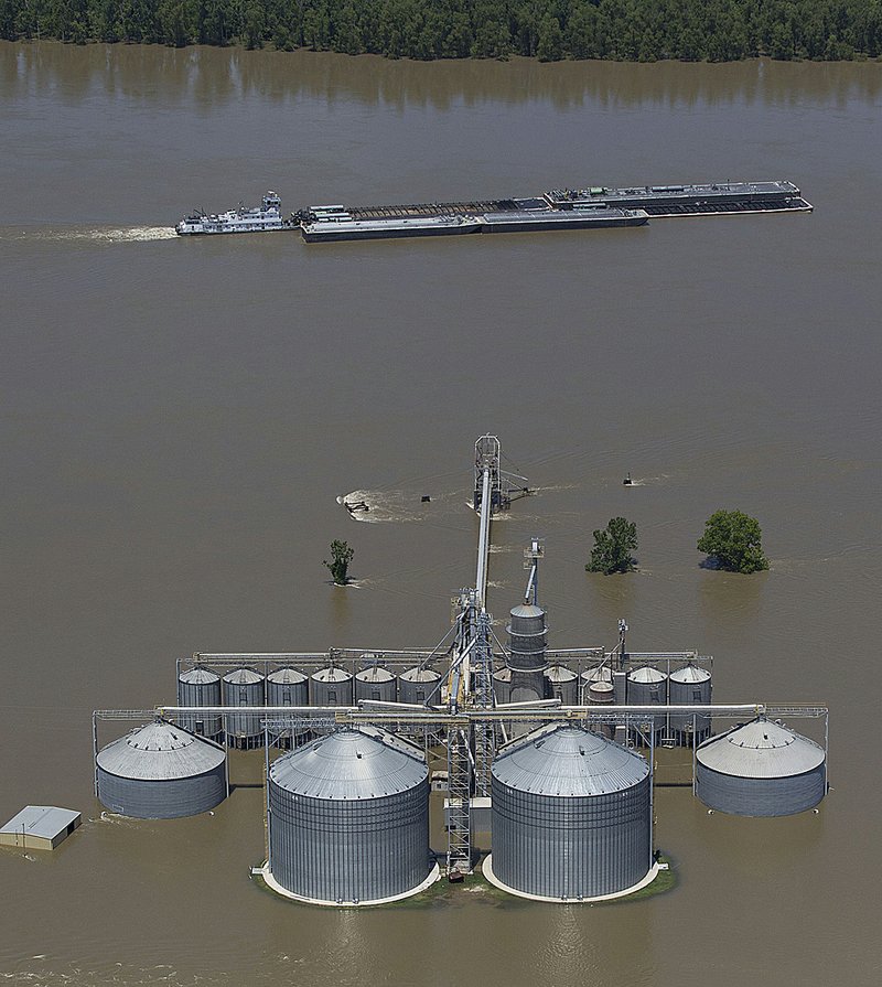
“Initial reports are that most of the [riverside grain] terminals are going to be open and able to handle wheat, but some locations will not be ready and will have to go to an alternate site because the grain bins are flooded or have been flooded.”
Commerce reliant on major Arkansas highways, however, is almost back to normal.
A stretch of Interstate 40 - between the Hazen and Brinkley exits - suffered no damage from its time underwater, said Glenn Bolick, spokesman for the Arkansas Department of Highways and Transportation.
The stretch of U.S. 67/167 that closed for a few days because of high water was also undamaged.
It will be six weeks before the agency will be able to evaluate other roads, Bolick said, adding those roads are the ones most likely to be damaged.
“The problem we’re going to have are the less-traveled secondary roads, which are not of the same quality as an interstate,” he explained.
Workers will contend with large potholes and unstable shoulders, he said.
Some Arkansas cities are beginning to see dry land again.
In Payneway, a small town in eastern Poinsett County, floodwaters continued to drop Tuesday, said Poinsett County Judge Charles Nix.
Last week, rising water from a spillway of the St. Francis River had flooded more than 50 homes and forced evacuations, Nix said.
In Greene County, officials Tuesday identified the body of a man who drowned Saturday in a flooded field near Delaplaine.
Authorities found 65-yearold Jim Skimahorn about 75 yards from his truck, which was under about 12 feet of water on Greene County Road 223, Greene County Coroner Richard Pace said Tuesday.
Pace thinks Skimahorn went to check on his flooded house on the county road near the Evening Star community, became disoriented by the floodwaters and drove into a water-filled ditch.
“Apparently, he got out of the truck and was either swept away or fell into a deep hole,” Pace said.
LOUISIANA
Port officials in Louisiana braced to see how closures along the Mississippi River will affect shipping, while emergency officials continued to evacuate areas south of the Morganza Floodway.
Mitch Smith, director of operations at the Port of South Louisiana, said he’s hopeful that the economic impact of interrupting barge traffic along the lower Mississippi will be minimal, “but it depends on how long that area is going to be closed.”
About 54 percent of all grain in the nation is exported through the Port of South Louisiana, which handles more than 60,000 barges a year, Smith said. The port, which extends 54 miles along the river between Baton Rouge and New Orleans, houses up to 2,500 to 3,500 barges a day, he said, not counting the ones traveling through.
Closing the Natchez stretch again would affect shippers at the Port of New Orleans, where about 35 percent of cargo ends up on either a barge, rail or truck, said Chris Bonura, the port’s spokesman.
“Those shippers have to make a decision: Do I wait for this closure to end? Do I take some of my cargo and put it in a rail car and move it upriver and wait for the rest of my cargo?” Bonura said.
In addition to the brief closing at Natchez, at least 10 freight terminals along the lower Mississippi River between Baton Rouge and New Orleans have suspended operations because of high water, The Associated Press reported. In many cases, their docks are already at water level or going under, said RoyGonzalez, acting president of the Gulf States Maritime Association.
Vessels scheduled to use the terminals will either have to wait out the high water or divert to other terminals or ports. Additional costs for delaying any one vessel routinely run $20,000 to $40,000 per day, port officials told the AP.
In addition to the terminal closures, the Coast Guard closed the Port Allen Route to Baton Rouge after the Port Allen Lock was closed because of high water, said Petty Officer Bill Colclough, spokesman for the 8th Coast Guard District external affairs office.
In New Orleans, the opening of the Morganza spillway north of Baton Rouge last weekend kept the port from being entirely closed. The Mississippi River began cresting there Monday near 17 feet.
“We don’t expect the river to get any higher than 17. It’s certainly not going to reach 18, which is when the Coast Guard said they would restrict traffic on the river ... and shut it down at 18 and a half. We don’t expect that that will happen,” Bonura said.
Meanwhile, floodwaters continued their slow rise in the Atchafalaya River basin as the Corps increased the number of gates open at the Morganza spillway from 11 to 15.
“We don’t have any plans to go any further at this point. We closed some and opened others to make sure there’s no scouring with that much water coming through,” said Corps spokesman Ken Holder.
Flows had decreased from 110,000 cubic feet per second at the spillway Monday, to 102,000 cubic feet per second Tuesday as water pressure began to equal out, Holdersaid.
Still, water from the Mississippi continued to fill the basin, nearly reaching U.S. 190 on Tuesday, Holder said.
As of Tuesday, Louisiana Gov. Bobby Jindal said more than 3,300 people have evacuated in St. Landry and St. Martin parishes ahead of the spillway water.
The spillway, which hadn’t been opened since 1973, is part of a system of locks, dams and levees that was built in response to the 1927 flood that killed hundreds and left many homeless.
Without the Morganza diversion, the Mississippi’s threat to levees at Baton Rouge would have been greater.
In Baton Rouge, the river is expected to crest this morning, according to the weather service. Still, river levels likely will remain high for up to three weeks, Jindal said.
The Corps expected Mississippi River water to commingle with that of the Atchafalaya River, reaching Interstate 10 sometime Tuesday evening, Jindal said.
All told, more than 14,000 Louisiana homes and businesses are threatened by the flooding, he said.
LEVEE PILGRIMAGE
In Desha County - where Arkansas City is located - the Corps and volunteers continue to monitor seepage and a couple of problematic sand boils, said County Judge Mark McElroy.
“We’re working in Chicot County, too,” he added. “In small counties, we don’t have the resources to handle something like this by ourselves.”
Both counties continue to hold town hall meetings to reassure residents and quell wildly inaccurate rumors, McElroy said.
And in Arkansas City, townsfolk say they will keep up their daily pilgrimages.
“Because we still have that large amount of water against our levee, we’re keeping a watch on it,” said Lori Beatty, who is co-owner of the Arkansas City Grocery.
Her store, she said, sits only 200 yards from the levee, which wreaks havoc on her nerves.
“But everybody in town checks on it regularly,” Beatty added.
And a bit of good news- the river has fallen by 3 to 4 inches, McElroy said Tuesday.
“We’ll take that. We still got our eyes on the weather though,” he added, referring to storms forecast for this weekend.
“The last thing we need is another glass of water or an inch of rain,” he said. “We’d just as soon have some sunshine.” Information for this article was contributed by Kenneth Heard and Paul Quinn of the Arkansas Democrat-Gazette and by Holbrook Mohr of The Associated Press.
Road closings The list below shows Arkansas roads closed because of high water or washouts as of Tuesday afternoon. Up-to-date listings can be found under “fl ood information” at www.arkansashighways.com
Road Location
ARKANSAS COUNTY Ark. 1 Bridge at the Arkansas/Monroe county line Ark. 17 Mile 9.89 to 14 at Ethel Ark. 44 Mile 5.8 to 6.3 BENTON COUNTY Ark. 264 Section 1 east of Bethel Heights CARROLL COUNTY U.S. 62 Mile 8.5 to 9.5 near Berryville Ark. 187 Section 0A at Beaver CROSS COUNTY Ark. 163 Two miles south of U.S. 64 at mile 0.15 near Levesque INDEPENDENCE COUNTY Ark. 37 Ark. 122 to Jackson Co.
JACKSON COUNTY Ark. 14 Cutoff at mile 3.3 to 3.94 at Ark. 367 Ark. 18 Section 1 from junction of 18 spur to Poinsett Co.
Ark. 37 Mile 5.5 to 6.48 near Grubbs Ark. 37 Ark. 18 to U.S. 67 Ark. 37 Mile 0 to 7.96 near Tuckerman LEE COUNTY Ark. 44 Mile 5.2 south of Marianna Ark. 78 Mile 0 to 4.3 near Aubrey Ark. 121 Mile 7.19 near Holub Ark. 121 Mile 7.5 at Marianna Ark. 243 West of Ark. 121 near Rondo Ark. 259 Mile 0.7 near Moro LONOKE COUNTY Ark. 13 5 miles north of Carlisle MISSISSIPPI COUNTY Ark. 118 Mile 0 to 2.75 at Joiner Ark. 120 Between Tuckertown and O’Donnell Bend Ark. 158 Mile 0 to 3.0 at the fl oodway Ark. 198 From the Mississippi River levee to the end of state maintenance MONROE COUNTY Ark. 1 Bridge at Arkansas/Monroe county line to Marvell Ark. 17 South of Holly Grove Ark. 146 Mile 0 to 9.6 near Lawrenceville Ark. 146 Mile 0 to 9.86 near Holly Grove Ark. 302 Mile 0 to 6.5 near Clarendon PHILLIPS COUNTY Ark. 85 Between U.S. 49 and Ark. 44 Ark. 146 Mile 0 to 5.35 Ark. 316 Mile 0 to 2.5 east of Turner Ark. 318 Between Ark. 85 and Ark. 44 Ark. 318 Ark. 316 to Ark. 20 POINSETT COUNTY Ark. 373 Ark. 14 to Ark. 163 Ark. 373 Ark. 14 to Ark. 214 near Landers PRAIRIE COUNTY Ark. 33 Mile 2.7 to 3.9 at I-40 overpass U.S. 70 West from Ark. 33 to the White River bridge toward DeValls Bluff Ark. 323 Mile 4.26 to 6.07 ST. FRANCIS COUNTY Ark. 50 Mile 0.5 north of Madison Ark. 50 Mile 1.0 U.S. 70 Between Ark. 50 and Ark. 38 WHITE COUNTY Ark. 36 Mile 8.03 east of West Point WOODRUFF COUNTY Ark. 269 Mile 3.7 to 4.7 near Pumpkin Bend SOURCE: Arkansas Highway and Transportation Department Arkansas Democrat-Gazette
Front Section, Pages 1 on 05/18/2011