A winter storm continued its blast through the state Friday, dumping up to a foot of snow in Northwest Arkansas and glazing power lines with three-quarters to an inch of ice and knocking electricity out to more than 62,000 homes and businesses.
RELATED ARTICLES
http://www.arkansas…">Weather puts chill on U.S. flightshttp://www.arkansas…">Wintry weather chills festivitieshttp://www.arkansas…">LR’s shelters open despite weather woeshttp://www.arkansas…">LR-region dodges worst of ice; Buffett cancels
At least two people died in weather-related accidents, police said.
The inclement weather forced the closure of countless schools and universities across the state and the cancellation of numerous events. Only essential personnel in state offices and in many cities were asked to work Friday.
Utility crews expected more power disruptions through Friday evening and this morning, fearing that ice-coated lines could snap as temperatures fell.

“We’re worrying about ‘flash freezing’ of lines,” said Rob Roedel, a spokesman for Electric Cooperatives of Arkansas, referring to when electrical lines freeze almost instantly in frigid weather. “This has all the elements of being bad tonight.”
Linemen in Mississippi County reported that wind gusts of up to 30 mph were making power lines “gallop,” or cross over each other and snap.
At its peak, more than 35,000 cooperative customers were without electricity, Roedel said. Arkansas Valley Electric Cooperative of Ozark and Rich Mountain Electric Cooperative of Mena saw the most disruptions, he said.
Entergy Arkansas Inc. reported about 13,000 homes and businesses without power at the peak of the storm, and Southwestern Electric Power Co. said about 12,000 customers lost service in Logan, Polk, Sebastian and Scott counties.
Most Entergy customers’ power should be back on by this evening, a news release from the utility said.
Entergy had prepared for the storm by mobilizing 6,700 workers from other utility companies and contractors. Crews that were still en route Friday afternoon were released to other areas that suffered extensive damage in the storm, such as Dallas.
“Fortunately, the scenario played out to be relatively mild,” Entergy Arkansas President and Chief Executive Officer Hugh McDonald said in the release.
More than 2,900 Fort Smith customers were also without electricity, according to Oklahoma Gas and Electric spokesman Christina Dukeman.
Police said Paul Yerby, 75, of Violet Hill was killed Thursday afternoon when his truck ran off a road in Izard County and struck a tree. Arkansas State Police said freezing rain was falling at the time of the accident.
Boyd Wallace Roundy, 62, died Thursday evening, when an ice-laden tree crashed onto the camper where he lived north of Dover, said Tommy Jackson, a spokesman for the Arkansas Emergency Management Department.
State police Cpl. Damron Dobson, 37, was injured when his patrol vehicle was struck Friday morning by a pickup on Interstate 40 in Monroe County, spokesman Bill Sadler said. Dobson was in his vehicle investigating a weather-related accident near the White River bridge when his vehicle was hit.
Dobson was taken to a Stuttgart hospital.
SLOW GOING ON ROADS
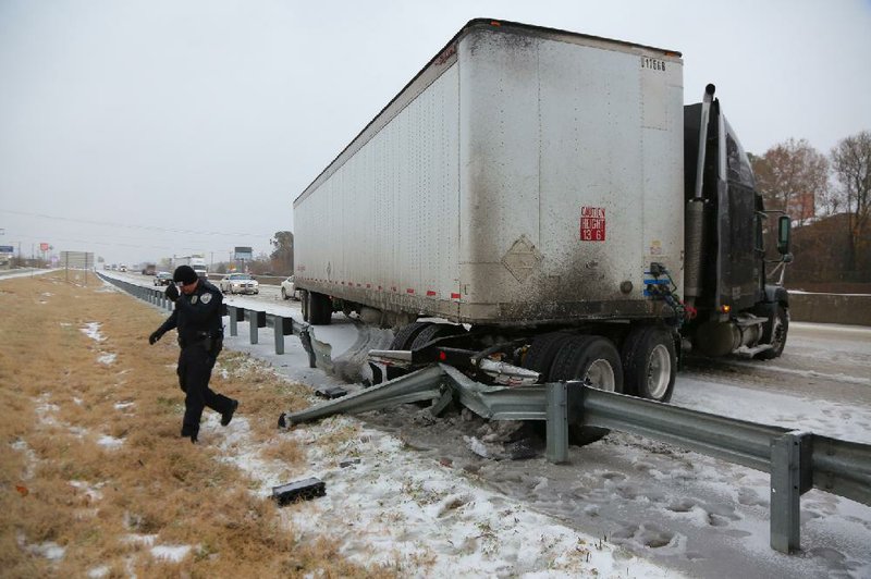
On Friday, traffic still was moving slowly on interstates and state highways in west and Northwest Arkansas, with jackknifed trucks impeding traffic, state Highway and Transportation Department officials said.
“Things remain challenging,” said Danny Straessle, a department spokesman. “Traffic is moving, but it’s slow. It’s just a matter of getting it addressed. They got walloped up there.”
Most transportation problems reported to the department’s headquarters were related to downed power lines and trees, he said.
“There are some points where power lines cross state highways, where the lines are low enough that tractor trailers can’t clear them,” Straessle said.
Straessle said department crews in many rural areas of Northwest Arkansas were busy clearing trees from rural roads, using chain saws where necessary.
Traffic continued at a slow pace in northeast Arkansas, as well, he said. But no problems were reported for drivers crossing the Mississippi River bridges to and from Memphis.
Widespread closings of schools and government offices in advance of the winter storm minimized traffic disruptions, Straessle said.
Highway crews were assigned to keep construction zones clear on Interstate 40 in Faulkner, Pope and St. Francis counties. “They are bad enough when the pavement is dry,” Straessle said.
Adriane Barnes, a spokesman for the Arkansas Forestry Commission, said three crews went to Pope, Logan and Sebastian counties to help clear fallen tree limbs. One crew cleared a rural Logan County road of debris for an ambulance that was responding to a home.
“It’s mostly slush and stuff,”Barnes said of snow-covered roads there. “But it could certainly get worse as the day goes on.”
In Northwest Arkansas, road crews battled snow-covered roads Friday morning.
“Our crews are out, trying to push off what snow and ice they can from the roads, but it is hard for us to keep up right now,” said Jeff Wheeler, an Highway Department district engineer in Harrison. “We are making a little headway.”
The weather also forced the cancellation Friday of more than 50 flights in and out of the Bill and Hillary Clinton National Airport/Adams Field in Little Rock, said airport spokesman Shane Carter.
One of the two commercial service runways remained open throughout the storm, and Carter urged passengers to check with airlines for the latest information on flights.
Crews swept the open runway free of ice early and were using chemicals to melt the remaining ice by Friday afternoon. They pushed water into drains to prevent it from refreezing Friday night.
It marked the second major disruption of airline service at the state’s largest airport. Heavy fog Tuesday and early Wednesday also forced a round of cancellations.
“It’s been a wild week,” Carter said.
Flights were also delayed and canceled at Northwest Arkansas Regional Airport and Fort Smith Regional Airport on Friday.
COLLISION OF AIR
The storm entered the northwest and west-central edges of the state Thursday, turning roadways slick with mixture of ice, freezing rain, sleet and snow. Arctic air from the Great Plains collided with warm, moist air from the Gulf, creating a wide band of freezing ice and snow that stretched from eastern Texas into southern Ohio.
By Friday evening, most of the storm had left the state.
Arkansas saw the complete array of wintry precipitation during the storm’s havoc.
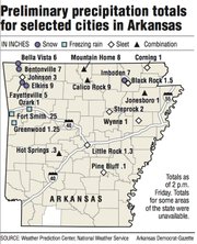
Most of Northwest Arkansas received up to 6 inches of a combination of snow and sleet, National Weather Service meteorologist Karen Hatfield of Tulsa said, although some spots took on more. Pea Ridge in Benton County measured 12 inches of snow.
Freezing rain fell throughout Friday in a line south of Paragould to Mena, meteorologists said.
In Little Rock, the inclement weather forced the cancellation of the state Capitol lighting and Pearl Harbor remembrance ceremonies set for today.
Capitol policemen remained at their posts by the entrances Friday, but many of the state’s constitutional offices were dark. The gift shop and cafeteria were closed, and the morning newspaper sat untouched outside the lieutenant governor’s office.
“As you might expect, it’s relatively slow,” Gov. Mike Beebe said.
REFREEZING FEARS
The southern half of the state saw few travel problems, but officials said freezing overnight would likely create hazardous driving conditions this morning.
The weather could have been even worse had there been a thicker layer of warm air sitting between 5,000 and 8,000 feet above the ground, said National Weather Service meteorologist Sean Clarke of North Little Rock.
When precipitation falls during winter storms, it is originally frozen, he said. As it falls through a warm-air layer, it thaws and then refreezes once it passes through that layer.
Depending upon the depth of the warm-air layer, the precipitation will hit the ground as either freezing rain, sleet or snow. The thicker the layer of warm air, the less the precipitation will freeze until it hits the ground.
“The surface stayed the same temperature,” Clarke said. “But the warm air [layer] cooled quicker than we anticipated. We were bracing for the worst.”
In Pocahontas, up to 4 inches of snow fell after Randolph County was peppered with sleet Friday morning.
Randolph County Sheriff Gary Tribble said he had to scrape his windshield free of snow and ice after every stop. But he didn’t mind, he said. In fact, the frozen precipitation helped him in an investigation.
Deputies responded to a report of a break-in at a Pocahontas home Friday morning. When they arrived, the burglar was gone, but Tribble and his men tracked footprints left in the snow to another home, where they arrested a man.
“We don’t necessarily like snow all the time,” Tribble said. “But it was a good factor today in getting our suspect.”
Sleet also drew scores of goldfinches to Dorothy Cooney’s home Friday in Wickes in Polk County.
“I had one goldfinch for about three days until today,” Cooney wrote in an email. “Earlier today, I saw, maybe, 20 finches. I think it’s more like 50 now.
“Now I have to take a loan out to feed them all,” she wrote in the email.
Union County Judge Mike Loftin drove around county roads Friday morning looking for any ice. His county and Columbia County were the only two in the state not under any weather watches or warnings.
But Friday, the two counties were issued winter-weather advisories.
“We had some sleet early, but then a huge rain came and washed it all away,” Loftin said. “I’m happy with a little bit of rain. If something’s falling, I’d prefer it to be liquid form.”
By late Friday, most of the precipitation left the state. A second, weaker round is expected to deliver some freezing rain to the southern portion of the state and sleet to the north this evening and Sunday morning. Temperatures were forecast to plummet into single-digit readings Friday evening across the northern top of the state.
Clarke said several Arkansas cities could set record-cold marks Friday evening and early today.
“We could see wind chills into the negative teens,” he said. “It won’t reach 40 degrees until either Wednesday or Thursday. This ice will be around for a while.” Information for this article was contributed by Debra Hale-Shelton, Sean Beherec, Aziza Musa, John Worthen, Noel E. Oman, Ryan McGeeney and Dave Hughes of the Arkansas Democrat-Gazette.
Front Section, Pages 1 on 12/07/2013