6:21 p.m. UPDATE:
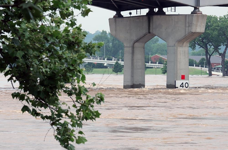
Flood waters inundated streets in Little Rock and North Little Rock Tuesday even as weather officials pushed back the Arkansas River’s crest date in the area.
The river had risen above its projected crest levels in Little Rock Tuesday afternoon, but officials said it had still not reached its full height.
National Weather Service Meteorologist Jim Reynolds estimated that the Arkansas River will crest at approximately 30 feet at 2 a.m. Wednesday, slightly higher and later than previous predictions.
Meteorologists are having a hard time pinpointing the flood's projected height and crest dates because the amount of water coming downstream is unprecedented.
— Clara Turnage
EARLIER:
The Arkansas River in Little Rock reached its projected crest level Tuesday, but the potential for heavy rain this week is raising concerns that the added water will worsen or prolong flooding in the state.
Measurements taken Tuesday afternoon showed the river in Little Rock 6.8 feet above its flooding stage at 29.8 feet, according to the National Weather Service.
Those levels haven’t been seen in Little Rock since the late 1950s.
“It’s not going to quickly fall back down,” said meteorologist Sean Clarke.
He noted that cities upstream from Little Rock that have shattered historic record river levels in recent days have remained high for days before levels began to fall.
Forecasters are also tracking storms this week that could bring up to four inches of rain across Arkansas.
The weather service said that rainfall could worsen flooded areas or extend the amount of time water levels stay high. But it likely won’t see river levels change much, Clark said.
“It’s not going to make Little Rock go up three or four feet,” he said.
Rising waters have already led to several roads and public park closures, including Pinnacle Mountain State Park.
Arkansas Department of Transportation spokesman Danny Straessle said the agency is watching roads near the river following numerous closures across central Arkansas.
“It could be worse,” he said. “We’re continuing to watch the water migrate and paying attention to what’s left to make its way through here.”
Straessle said the department shut down sections of Arkansas 300 west of Pinnacle Mountain. Little Rock and North Little Rock have also closed multiple streets in recent days because of high water.
Forecasters said the river in Pine Bluff is already at major flood stages and is expected to reach its highest point on Thursday as a deluge of water heads downstream. Gov. Asa Hutchinson visited Pine Bluff Tuesday to assess the damage.
High waters overtopped at least two flood levees in western Arkansas, and the fast-moving river broke a levee about 100 miles upstream from Little Rock in Yell County.
The Arkansas National Guard has been following the floods since the governor deployed teams last week. The local American Red Cross has taken in more than a hundred people at one of its 10 shelters for people displaced because of the flooding.
Officials have blamed at least one death on the flooding.
— Youssef Rddad, with contributions from The Associated Press and Josh Snyder