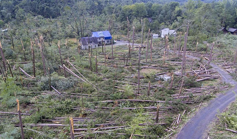
The National Weather Service in North Little Rock confirmed Wednesday that at least three tornadoes touched down Tuesday as a storm system made its way across central and north-central Arkansas.
Meteorologist Willie Gilmore said a weather service survey team had confirmed EF0 tornado damage in the Shady Grove community in Faulkner County, EF1 tornado damage in Conway County and EF2 tornado damage in Cleburne County. The tornadoes spawned from a supercell as it made its way into Central Arkansas before moving northeast and eventually out of the state..
Storm reports from Tuesday included damage to houses, timber and power lines but no fatalities were reported. Among the areas reporting damage were Plumerville in Conway County; Wooster and areas north of Greenbrier and into Guy in Faulkner County; and Heber Springs in Cleburne County.
The weather service will continue to survey additional areas where other possible tornadoes were reported.
"We might have additional details [today], so the numbers might change," Gilmore said.
The latest round of tornadoes comes on the heels of eight confirmed tornadoes last week in northeast Arkansas as the remnants of Hurricane Laura moved through.
[Video not showing up above? Click here to view » https://www.youtube.com/watch?v=Qx4-3VOolpQ]
Three of those were in Craighead County and were rated as EF0 or EF1 tornadoes on the Enhanced Fujita Scale. The strongest tornado was an EF2 in Randolph County.
The Enhanced Fujita Scale rates tornadoes from the weakest (EF0) to the strongest (EF5). EF0 tornadoes include wind gusts between 65 and 85 mph. EF1 tornadoes have winds between 86-110 mph, while EF2 winds are 111-135 mph and EF3 winds are 136-165 mph. EF4 winds are 166-200 mph, and EF5 winds are higher than 200 mph.
Gilmore said the recent tornadic activity wasn't surprising because inland tropical systems commonly produce tornadoes.
"It's also the beginning of September, and with the changing of seasons you normally start to see severe weather," he said.
Forecasts predict much of Arkansas could have flash flooding again today, with the greatest risk in western and central Arkansas.
Extensive flooding has occurred over the past few days in parts of northern and western Arkansas as a rare weather event soaked those areas, but meteorologists said those areas could get a break from heavy rainfall as the storm front moves south.
[Gallery not loading above? Click here for more photos » arkansasonline.com/93storm/]
The National Weather Service said Wednesday that 10 to 15 inches of rain had fallen over the past seven days in portions of Howard, Polk, Montgomery, Scott, Sevier, Logan and Sebastian counties.
Soil moisture in parts of western Arkansas is around 95% to 100%, and it's reached 60% to 80% in some areas in the central part of the state due to heavy rainfall.
That means it will take little additional rainfall to trigger widespread flash flooding in those areas.
"An inch or half an inch of rain could cause issues," Gilmore said. "Polk and Scott counties have had the worst of it the past four days."
The weather service said Mena's rainfall total over the past seven days is roughly 12.94 inches, which included more than 5 inches of rain over a 24-hour period this week.
Gilmore said it appears the storm front is moving away from western Arkansas, noting that the heaviest rain Wednesday was around Danville in Yell County and Clarksville in Johnson County.
"We didn't get any additional reports of flooding [on Wednesday], so it appears to have calmed down," he said. "It appears to be transitioning farther south, so that is good news, and hopefully that trend continues because they will have a lot to clean up out there."
The weather service said there is a chance for moderate to major river flooding in areas that get 2 to 3 inches of rain through today.
Officials are paying close attention to the Petit Jean River in Danville. It was already at major flood stage Wednesday and is expected to crest at 27.6 feet. That would put it among the river's top 10 highest levels.
"It gives you a good idea of how much water is running through that area," Gilmore said.
