Tropical Storm Fred made landfall in the Florida Panhandle on Monday afternoon, lashing the Gulf Coast with powerful winds that could cause a dangerous storm surge, the National Hurricane Center said.
The storm came ashore near Cape San Blas, Fla., southeast of Panama City, the hurricane center said Monday afternoon, and was moving north-northeast at 10 mph with maximum sustained winds of 50 mph.
Tropical storm warnings remained in effect along Florida's Big Bend Coast to the Steinhatchee River, while parts of the Panhandle coastline were under a storm surge warning, meaning that rising water could bring the "danger of life-threatening" flooding in those areas.
"This is a life-threatening situation," the hurricane center said. "Persons located within these areas should take all necessary actions to protect life and property from rising water."
Fred is forecast to bring 4-8 inches of rain to the Florida Panhandle, with isolated totals of up to 12 inches. The heavy rainfall could lead to flooding with possible rapid river rises, the center said.
Along parts of the Florida Panhandle coastline, the storm surge could reach 3-5 feet, the center said. Two feet of flowing water is enough to float a vehicle.
According to the National Hurricane Center, Fred's tropical storm-force winds extended 115 miles from the storm's center.
Parts of southeast Alabama through western and northern Georgia could see rainfall totals between 4-7 inches, with isolated totals up to 10 inches, the center said.
On the Alabama coast, the city of Orange Beach offered sand and bags to residents worried about flooding. A half-dozen school systems shut down Monday, and a large church opened as a shelter. Salt water was washing over roads and causing flooding in low-lying areas of Dauphin Island, a coastal barrier south of Mobile, Alabama, at midday Monday, Mayor Jeff Collier said.
"We've certainly been in a lot worse than this, but that's no reason to be complacent," said Florida's Bay County Sheriff Tommy Ford. "The less people out on the road, the better. We do expect some heavy rain from this storm."
Forecasters also noted that tornadoes could form across parts of the Florida Panhandle, southwestern Georgia and southeastern Alabama.
Fred formed last Tuesday as the sixth named storm of the 2021 Atlantic hurricane season.
[Video not showing up above? Click here to watch » https://www.youtube.com/watch?v=EfSHHNZLdhw]
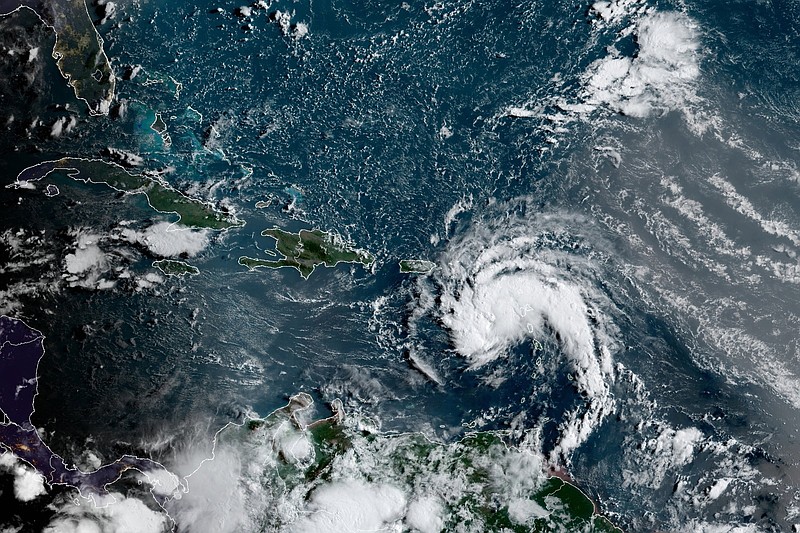
It became a tropical storm just south of Puerto Rico on Aug. 10. On Wednesday, authorities there said that power outages and flooding had been reported across the island.
The storm made landfall in the Dominican Republic on Wednesday, where heavy rain caused floods in some parts of Santo Domingo and uprooted trees. Fred then brought heavy rain to eastern Cuba and some of the Bahamas on Friday morning before passing near the Florida Keys on Saturday.
Forecasters are also monitoring Tropical Depression Grace, the seventh named storm of the Atlantic season, which formed in the eastern Caribbean on Saturday morning.
Grace was expected to dump up to 15 inches of rain on Haiti on Monday and today to cause mudslides and flooding, just days after the country was struck by a 7.2-magnitude earthquake, the hurricane center said.
Grace was centered 60 miles southwest of Port-au-Prince, Haiti, with top winds of 35 mph Monday night. The storm was moving west-northwest at 13 mph, bearing down on the disaster area with what forecasters said could total 10 inches of steady rainfall, and still more in isolated areas. The hurricane center warned that flash floods and mudslides were possible, especially along Hispaniola's southern coasts.
Grace was expected to become a tropical storm again as it passes between Cuba and Jamaica today and could be near hurricane strength when it approaches Mexico's Yucatan peninsula Wednesday night. A tropical storm watch was in effect for the entire southern coast of Haiti, most of the southern coast of Cuba and the Cayman Islands.
Meanwhile, the season's eighth tropical depression strengthened into Tropical Storm Henry on Monday near Bermuda, about 145 miles offshore. A tropical storm watch was in effect for the island as the system's top winds grew to 40 mph.
Matthew Rosencrans of NOAA said that an updated forecast suggested that there would be 15-21 named storms, including 7-10 hurricanes, by the end of the season Nov. 30.
Last year, there were 30 named storms, including six major hurricanes, forcing meteorologists to exhaust the alphabet for the second time and move to using Greek letters.
It was the highest number of storms on record and included the second-highest number of hurricanes on record.
Information for this article was contributed by staff members of The New York Times and staff members of The Associated Press.