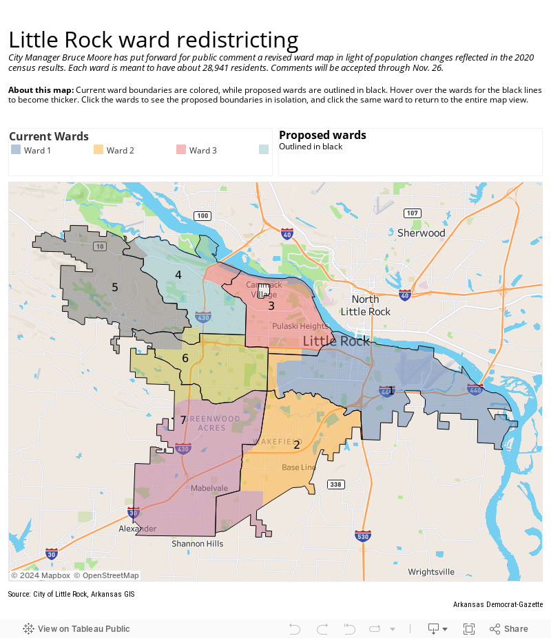
Little Rock City Manager Bruce Moore has put forward for public comment a revised map of the city's seven wards that reflects population changes from the 2020 census but largely maintains the current map's structure.
Mayor Frank Scott Jr. had proposed a more radical redrawing of ward boundaries. City board members last month voted to hand Moore the authority for the decennial process.
Public comments will be accepted online at littlerock.gov/2020wards through Nov. 26, according to a city news release.
The latest census found Little Rock's population grew by more than 9,000 since 2010 to exceed 200,000 residents for the first time.
The redistricting process for the city's seven wards is meant to ensure that each ward maintains a population roughly equivalent to the rest. The new map seeks to draw the boundaries so that approximately 28,941 people live in each ward.
Voters in each ward elect a representative to the city's Board of Directors. The board's structure also provides for three at-large positions elected by the city's entire pool of voters.
[LITTLE ROCK WARDS: Map of current and proposed Little Rock wards not appearing above? Click here » arkansasonline.com/1118lrwards/]
City board members on Oct. 19 approved an ordinance to formally give Moore -- along with any individuals he chooses -- the responsibility for this year's redistricting effort. Before the board's action, Scott had signaled he intended to lead the process.
Before they voted to adopt the ordinance, Scott had provided board members with two draft redistricting maps.
Scott's stated priorities for the redistricting process included eliminating Interstate 630 as a dividing line.
While one of Scott's two draft maps closely resembles the version put forward for public comment this month, the other map from the mayor would have made more substantial changes to the ward boundaries.
It would have effectively dissolved the city's northwest-central districts of Ward 3 and Ward 4 in favor of "North Central" and "Midtown" wards. The mayor's proposed "North Central" ward would have largely extended east-west along a northern stretch of the city close to the Arkansas River and Interstate 430.
The Ward 3 and Ward 4 seats are currently held by city directors Kathy Webb and Capi Peck, respectively.
Webb was critical of Scott's proposed map last month.
In an email to the Arkansas Democrat-Gazette, she wrote that the proposal "has serious flaws which are easily seen. I hope we can have positive discussions, which include our neighborhood associations and residents, which result in something beneficial for our city."
Webb did not return a voicemail Wednesday.
According to ward-level maps released by the city, the proposal under consideration would see two wards with the highest concentrations of any single racial or ethnic group.
Ward 1 would encompass the downtown core, areas around the airport and communities to the west and would have a population that is roughly 70% Black, 22% white and 7% Hispanic.
Ward 3 would encompass an area north of I-630 that includes University Avenue, the Heights and the area around Cammack Village, except for a sliver south of the freeway. It would have a residential population that is roughly 70% white, 17% Black and 3% Hispanic.
The total population in Ward 3 would also be the largest among the redrawn wards, with an estimated 30,022 residents.
West Little Rock's Ward 5 would also have a concentrated white population. Under its new proposed boundaries, residents would be approximately 68% white, 16% Black and 3% Hispanic.
Other changes to the current ward map that can be seen in Moore's version include Ward 1 absorbing a strip of land near I-630 that is currently part of Ward 2.
Under its present boundaries, a thin slice of Ward 2 reaches up to touch a section of the freeway from the main area of the ward in south-central Little Rock.
Additionally, under Moore's proposal, southwest Little Rock's Ward 7 would take part of the city's western edge from what is currently Ward 6.
At the end of the city board's meeting Tuesday, Scott brought up Moore's promulgation of the maps and the online public-comment portal.
Scott said he believed that "in addition to the online format, we have residents who may not have access to Internet; we have residents that would like to see some type of in-person -- socially-distant, of course -- opportunity to view the maps, make comments and things of that nature."
At-large City Director Joan Adcock requested that seven meetings be held, one in each ward.
Scott indicated the meetings would be hosted by Moore and staff from the Planning and Development Department.
Webb expressed skepticism about the possibility of hosting seven meetings in the next two weeks, with the Thanksgiving holiday falling on one of the weeks.
"This board did impose a timeline on Mr. Moore," Scott said, referring to the language of the October ordinance.
The measure said the redistricting process would have to be completed by the end of November and the board would have to vote on the new map during its Dec. 7 meeting.
Moore indicated the timeline would not be viable if officials held seven meetings throughout the city.
Vice Mayor Lance Hines, who represents Ward 5, suggested joint meetings could be held between certain wards.
During the same meeting Tuesday, board members rejected an ordinance sponsored by at-large City Director Antwan Phillips to transform the board's three at-large positions into regional districts via a 2022 referendum that would have put the question to voters.
According to Phillips' proposal, those regional districts would have encompassed one or more wards.