The first of two rounds of storms that could bring tornadoes, hail and damaging winds is expected to enter the state around 7 p.m. Tuesday, the National Weather Service said.
The second round of weather is forecast to be a long line of storms moving across the state from the west to the east, a severe weather briefing from the weather service said Tuesday.
Joe Goudsward, a meteorologist with the National Weather Service, said Tuesday that this event will primarily be an overnight event.
“From around 7 p.m. until midnight there will be scattered storms, still the possibility of severe weather and tornadoes,” Goudsward said. “But the main show will show up around midnight in Northwest Arkansas and the Little Rock Metro area should see it by sunrise.”
The line of storms carries the risk for embedded tornadoes, he said.
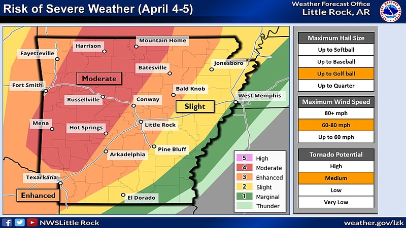
Much of Arkansas, including Little Rock, is at an enhanced risk for severe weather. Some northern and western parts of the state are at a moderate risk, the forecaster said.
An enhanced risk for severe weather is defined as “numerous severe storms possible,” the briefing said.
Goudsward said, in this case, a moderate risk means that storms in those areas may be stronger and more likely to occur.
Excluding much of the eastern fourth of the state, there is a 10% or greater chance of significant tornadoes — EF2 or EF3 — in Arkansas, the briefing said. There is a medium potential for tornadoes.
Winds could be as strong as 80 mph, and hail could be as big as a golf ball, forecasters said.
Little Rock could see up to an inch of rain while parts of southeast Arkansas could see a total of 3 inches through Friday.
“Any flash flooding potential should stay limited to southeastern Arkansas,” the briefing said.
The forecaster warned that, due to the timing of this severe weather, people may not get alerts as quickly.
“What people need to keep in mind is that this event is different from Friday’s. That was during the day. People were at work and awake and could see what was going on. This is a primarily overnight event and people need to be ready,” Goudsward said.
He said Arkansans should prepare a safety kit with a flashlight and a first-aid kit as well as make a plan about where to take shelter if severe weather hits. They should also make sure they have multiple ways to get weather alerts, including a way that could wake them up.
“I always recommend a NOAA weather radio; it will give a very loud tone. It is designed to wake you up,” Goudsward said. “So, if you have one, make sure it is on and plugged in and you have batteries.”
He also said keeping the weather alerts active on a cell phone could help ensure important weather information is shared overnight.
“Keep your phone on your nightstand, charging and the volume all the way up and you should be able to hear that overnight as well,” the meteorologist said.