The National Weather Service on Saturday extended a severe weather warning for parts of north Arkansas, while issuing a severe weather warning for Russellville, Dardanelle and Atkins.
The warning for those three communities was set to last until 5:45 p.m., while the extended warning for Mountain View, Clinton and Fairfield Bay was set to expire at 5:30 p.m. Saturday. Hail as large as 2 inches had been reported in north Arkansas, and hail the size of golf balls was reported at 5:08 p.m. Saturday as the storm moved into Stone and Cleburne counties.
A severe weather warning was also issued for Mount Ida, Oden and Crystal Springs until 5:45 p.m. Saturday. The National Weather Service reported that the storm in that area could produce quarter-sized hail and 60 mph winds.
The warnings followed a severe thunderstorm watch issued at around 4:15 p.m. Saturday. That covered most of southern Arkansas, the Central Arkansas area around Little Rock and a large portion of northeast Arkansas, and was set to expire at 10 p.m. Saturday.
3:50 p.m.: Hail reported in multiple Northwest Arkansas counties as storms move through state
Hail was reported in Northwest Arkansas on Saturday afternoon as a line of severe storms moves through the state.
At 3:34 p.m. Saturday, the National Weather Service reported hail the size of golf balls as the storms moved east-northeast from Pope County into Searcy County.
That report followed one from the service shortly after 3 p.m. that hail stones of up to 2 inches had been reported in the Fort Smith area.
11:05 a.m.: Forecasters: Risk of severe weather for most of state on Saturday
A line of severe storms that could produce high winds and large hail is in Arkansas' forecast Saturday evening, according to the National Weather Service.
The weather service has issued a severe thunderstorm watch for Northwest Arkansas and the River Valley until 7 p.m. Saturday.
[WEATHER RADAR: Click here for updates » arkansasonline.com/radar]
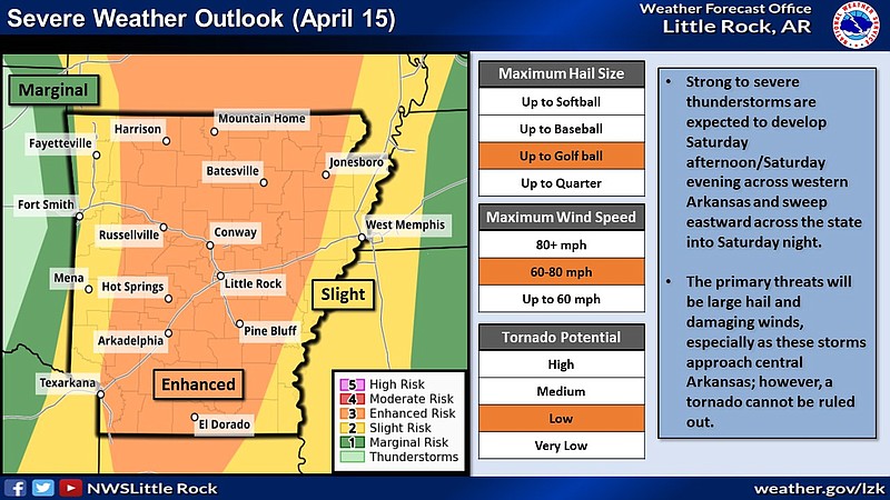
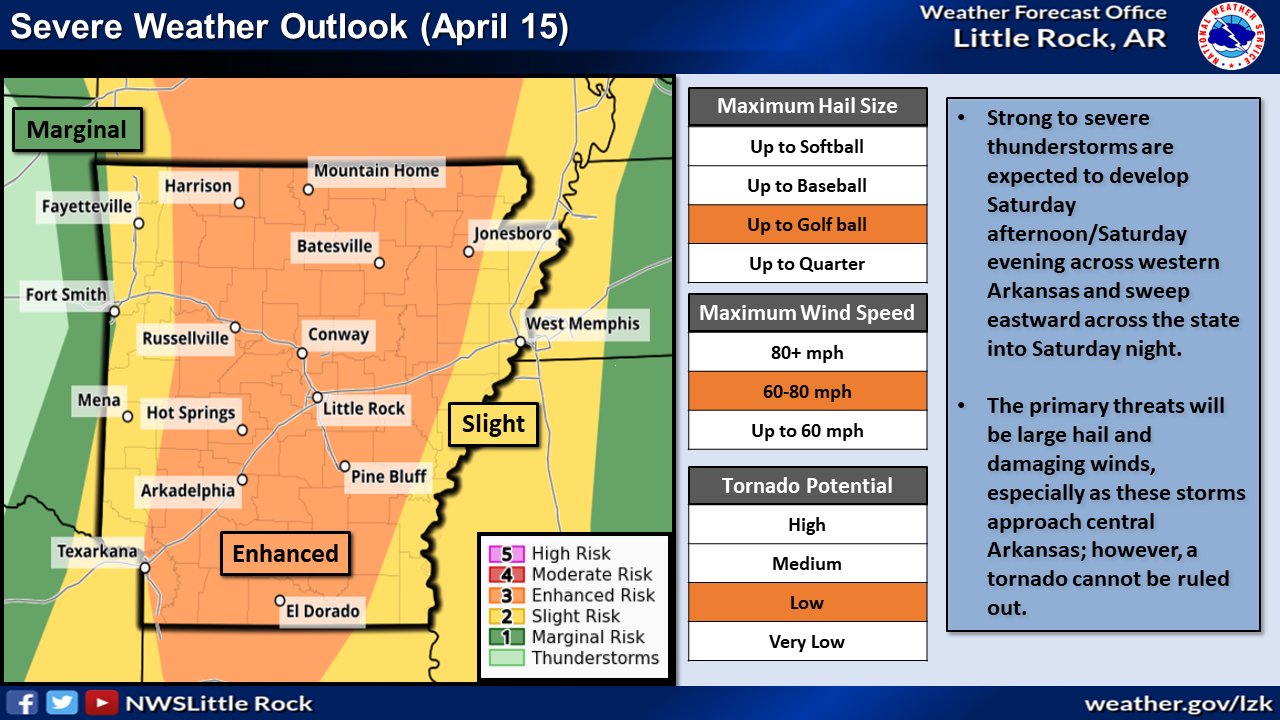
The storm front — which has a majority of the state under an enhanced risk of severe weather — could contain golf ball-sized hail and winds as strong as 80 mph, a severe weather briefing from the weather service in North Little Rock said.
The National Weather Service defines an enhanced risk as several severe storms that could produce very large hail, damaging winds or a tornado, a tweet from the weather service said.
"The primary hazards with these storms will be large hail and damaging winds; however, a tornado cannot be ruled out," the briefing said on Saturday morning.
According to the National Weather Service, the entire state has the potential to see large hail, but latest trends show these thunderstorms being most impactful across western and central Arkansas.
In Central Arkansas, the area is forecast at having up to 44% chance of seeing hail.
According to the weather service's modeling, the storms will start to develop around 4 p.m. and will begin forming into a line as they approach the Little Rock metro around 6 p.m.
By 7 p.m., the storms could form into an organized line stretching across the state. The forecast has the storms starting to leave the state around 9 p.m., the briefing said.
"Discrete cells that develop ahead of the main line of storms will have the potential to produce tornadoes," the briefing said.
Central and eastern Arkansas could see up to an inch and a half of rain as a result of the storm.
 This graphic from the National Weather Service shows parts of the state at risk of seeing severe weather on Saturday. (National Weather Service/Twitter)