Forecasters are predicting a possible significant severe weather event Wednesday that would be “somewhat unusual” for August, a severe weather briefing from the National Weather Service said.
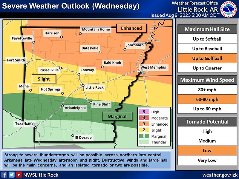
“Strong to severe thunderstorms will be possible across the northern half of Arkansas late Wednesday afternoon and night,” the briefing said.
These storms could be capable of producing large hail, damaging winds and even isolated tornadoes, said Thomas Jones, a meteorologist with the National Weather Service in North Little Rock.
Jones said Wednesday morning that the storms in Northwest Arkansas could start in a 4 p.m. to 7 p.m. window and move south or even southeast.
“Toward evening, a strong storm system and associated cold front will approach from the Plains. A new round of strong to severe thunderstorms will likely develop in southern Missouri and sweep into northern Arkansas,” the briefing said.
Jones said that this event was not typically what Arkansans would see in the summer.
“This could be a significant severe weather event, and somewhat unusual for August. This kind of event is more reminiscent of spring,” the briefing said.
Much of northern Arkansas, including Fayetteville, Jonesboro and Bald Knob, are at an enhanced risk for severe weather.
An enhanced risk is defined by the weather service as “numerous severe storms possible” and the storms could be more persistent and widespread, the briefing said.
Little Rock and much of Central Arkansas, including Conway and Hot Springs, is at a slight risk of severe weather.
The slight risk means that scattered severe storms are possible and that storms might be short-lived or isolated and intense, the weather service said.
“As of right now Little Rock is on the southern edge of the storms but that doesn’t mean we’re completely out of the woods,” Jones said.
He said that central parts of the state could see storms during that 10 p.m. Wednesday until 2 a.m. Thursday morning window.
A southern portion of the state including Pine Bluff and Arkadelphia is at a marginal risk for severe weather, meaning that isolated severe storms are possible, the briefing said.
There is a chance for flash flooding in relation to the storms.
“Torrential downpours are expected in places. The forecast calls for two to three inches of rain in parts of the north, and this may result in localized flash flooding,” the briefing said.
“In August we have a lot of water in the atmosphere that could cause flash flooding. These storms are predicted to be efficient rain producers,” Jones said, “We might not be used to flash flooding in summer but I’d really stress that if people see a roadway covered by water that they turn around, don’t drown.”
The meteorologist said Arkansans should have weather alerts available in multiple places, like a cell phone, local TV station or a NOAA weather radio.
“This event shouldn’t impact the 9 to 5 or 8 to 5 folks too much, but because it is later we always suggest having multiple ways to get weather alerts,” Jones said.