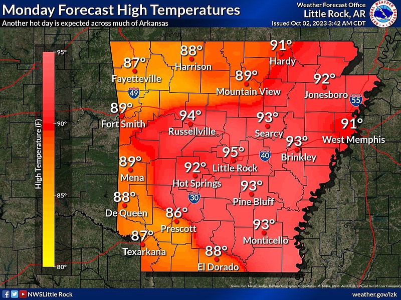
Parts of Arkansas could see record-breaking high temperatures on Monday, and Little Rock already broke a record on Sunday with a high of 95 degrees, according to the National Weather Service.
Temperatures in the upper 80s to mid 90s are expected on Monday.
The temperatures are so warm that some cities could approach or break records for the calendar day, said Sean Clarke, a meteorologist with the weather service in North Little Rock.
“For the first half of the week, we will see well above normal temperatures all over the state,” he said Monday morning. “Little Rock usually has highs in the 80s around this time.”
Little Rock's Sunday high of 95 degrees beat a record of 94 degrees that was set in 1953, a post on X, the social media platform formerly known as Twitter, said.
Clark added that leaves "are likely falling because it is so dry and not because the temperatures are cool."
He said a ridge of high pressure has settled across Arkansas and much of the midwest.
“It’s really keeping things well above normal for now, but it is set to move during the second half of this week,” he said.
Some rain is also forecast for most of the state on Wednesday, the meteorologist said.
“Everyone is going to see some rain, but the amounts may vary,” Clarke said. “The western part of Arkansas could see one to two inches and the eastern part of the state is forecast to see a quarter of an inch up to half an inch.”
He said there may be some thunderstorms, but the weather service is not predicting any severe weather right now.
“But that may change, it is still a bit far out to make that call in the forecast,” Clarke said.
There is a chance of flash flooding in some areas, he said.
“Flash flooding is always a concern when the ground is this dry,” Clarke said. “But even more so because fallen leaves can clog storm drains and cause issues in urban areas.”
After the rain leaves the state, temperatures will be noticeably cooler, he said.
“It actually is forecast to be below average temperatures for the weekend,” the meteorologist said. “It will be good apple picking and pumpkin patch weather.”
Next week, the state is expected to warm up again.
“After the weekend, it does look like temperatures will gradually warm, but just won’t get as warm as this week. Hopefully we won’t get back into the 90s,” Clarke said.