The National Weather Service survey crew has determined that a microburst with strong winds caused the damage of buildings and uprooting of trees in Scott during a storm Monday evening.
Dan Koch, a meteorologist with the National Weather Service office in North Little Rock, said that several trees were uprooted, some outbuildings were heavily damaged or destroyed and some roofs and metal siding were damaged during the storm.
"What our survey team discovered was that it was not a tornado, but widespread straight line wind damage from a microburst," Koch said Tuesday afternoon. "The winds were around 90 mph, which is nothing to sneeze at."
The damage was all blown in one direction and there were no signs of rotation, Koch said.
A microburst is defined by the weather service as "a localized column of sinking air within a thunderstorm."
"That air gets dragged down with the precipitation and it has nowhere to go but forward, which causes these damaging straight line winds," the forecaster said.
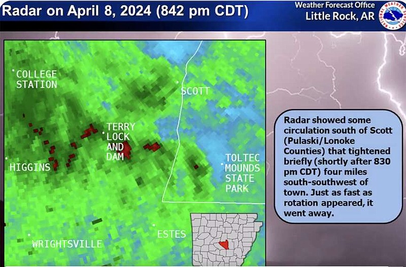
Around 8:30 p.m. on Monday, "[the] radar showed brief rotation about 4 miles south-southwest of Scott," the weather service said in a post on X around 12:35 a.m. Some storm damage was reported in the southeast Pulaski County area.
The Pulaski County Sheriff's Office shared an urgent weather update for the Burns Road area in Scott just after 11:30 p.m. on Monday.
Chris Buonanno, a meteorologist with the National Weather Service office in North Little Rock, said Tuesday morning that a crew was sent to Scott to survey the damage.
Multiple mobile homes were overturned and around two to three inches of flooding had occurred in the area, Kristin Knox, a spokesperson for the sheriff's office, said Tuesday morning.
"We didn't see any hail, but it seemed like wind damage. Some of the fire departments that responded said it looked like a tornado because of the damage," Knox said.
No injuries reported, she said.
Matt Ramsey, a spokesman for Entergy, said there were some customers still left without power Tuesday afternoon.
"While there wasn't any major damage to electrical equipment, there were some trees blown down on power lines," he said. "At peak, about 205 customers were out in the Central Arkansas area and as of this afternoon, only 24 customers in the Scott area are still without power."
Ramsey said the hope is that all power is restored to customers by 5 p.m. Tuesday.
He said the area is swampy, which makes it difficult for crews to get in there and restore power.
"Overall, we did really well considering there were strong winds and we didn't have too much damage to the electrical grids or systems, no broken poles or anything," he said.
OTHER STORM DAMAGE IN STATE
Scott was not the only area in Arkansas to report some damage from the storms on Monday evening.
There were some reports of hail in Miller and Saline counties, according to storm reports sent to the National Weather Service.
Other reports stated there were strong winds in Lee County that removed a roof from a home. Another report from Hempstead County stated that a tree was knocked down due to strong winds.
RAIN, STORMS THROUGH WEDNESDAY
Koch said that there were storms forecast for the southern parts of Arkansas, south of Pulaski County.
"The heavy rain and real worry about severe weather is in southern Arkansas overnight tonight into Wednesday," he said.
The forecaster said it is possible some southern portions of the state could see some damaging winds and hail.
The main concern is the possibility of flash flooding.
A flood watch has been issued in portions of central, southeast and southwest Arkansas, the watch said. This includes areas in Grant, Jefferson, Lincoln, Dallas, Hot Spring, and Clark counties.
The watch will remain in effect until Wednesday evening.
"Excessive runoff may result in flooding of rivers, creeks, streams, and other low-lying and flood-prone locations," the watch said, "Those living in areas prone to flooding should be prepared to take action should flooding develop."
"Some areas in southern Arkansas could see anywhere from three to five more inches of rain in the next 48 hours, it'll be a big, wet mess in the area," the forecaster said. "Little Rock could see another two to three inches."