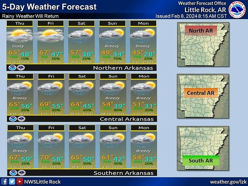
Most of Arkansas can expect a couple of rounds of rain through the end of this week and the weekend, the National Weather Service said.
"Rainy weather is expected to return to the state over the next five days as a couple of weather systems move through the area," the weather service said in a post on X Thursday morning.
Rain could start in central and southern parts of the state by Thursday with more widespread rain possible during the weekend, the post said.
Justin Condry, a meteorologist with the National Weather Service in North Little Rock, said that the first round of rain will be lighter.
"Today it will be light, scattered rainfall that might be more of a sprinkle," Condry said Thursday morning.
More widespread rain is possible through the weekend with southern and Central Arkansas forecast to see the most rain.
"By Sunday night we could see an inch statewide with higher amounts possible, depending on bands of heavy rain," Condry said.
Rain in Little Rock is forecast to be seen mostly starting Friday night into Saturday morning with some brief breaks, he said.
The forecaster said Little Rock would see about half an inch of rain and then Sunday would bring heavier showers, which could provide an additional inch of rain.
Condry said there were not any concerns of severe weather associated with the rounds of rain in the forecaster.
"We might see some gusty winds on Sunday up to possibly 20 or 25 mph, and we could hear some thunder but it is mostly just going to be heavy rainfall," the forecaster said.
The rain could possibly impact some of the rivers that remain in flooding stages, he said.
"The White River tends to be really flashy with rain, so there is a chance it will have flooding or flash flooding conditions," he said. Other rivers that are still high might also be at risk to flood or to be at levels that will have them remain in flood stages.
"Flash flooding in general is a bit of a concern, considering the ground is still somewhat saturated, so poorly drained areas might be at risk," Condry said. "Mainly, just be careful and don't cross roads that are covered in water, you don't know what's under there."
He also said drivers should slow down and use extra caution due to wet roads.
"Give yourself extra time and give other cars around you more space," Condry said.
FORECASTERS WATCHING COLD CHANCES
While northern Arkansas may not get as much rain, there is a chance for wintry weather early next week.
Snow or sleet is most likely in the northwest corner of the state overnight on Sunday into Monday morning, the weather service said in a post on X Thursday morning.
Up to an inch of accumulation from a light dusting could have some travel impacts, the post said.
The forecaster said Little Rock will be too warm and likely will only see rain.
"Additionally, some factors for another US Arctic air intrusion are trending towards favorable based on large scale patterns," the post also said.
Condry said temperatures are already dropping slightly this week and trending towards normal or below normal, but the data is looking at a longer range to see if Arctic air will enter the state once more.
There is a chance closer to the middle or end of February, the forecaster said.
"Initially, I would say it is probably not going to be as cold. We're going to be looking at highs in the 30s," he said. "But it is so far out that we are still monitoring."