Parts of Arkansas are forecast to receive cold and stormy weather this week and through the weekend, the National Weather Service said.
The weather service is monitoring two storm systems this week, one that began passing through the state on Monday and continues today and one that will arrive on Thursday and Friday, a winter weather briefing from the service said Monday.
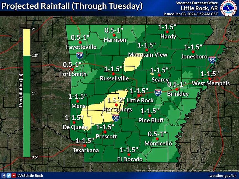
The first system is “primarily a rain maker, and there will be some rumbles of thunder in places,” the briefing said. One to two inches of rainfall are predicted across much of the state.
Strong wind gusts are the primary concern with that storm system, said Jeff Hood, a meteorologist with the National Weather Service office in North Little Rock.
“This is a weeklong busy winter weather week,” Hood said.
All of the state is under a wind advisory through 6 p.m. today, the weather service said in an online forecast.
“Wind gusts of 30 to 40 mph will be common. Some of the higher terrain could see gusts as high as 50 mph,” the briefing said.
“We’ve seen wind gusts up to or even a little above 30 mph in Little Rock already,” Hood said Monday morning.
Matt Ramsey, a spokesperson for Entergy, said that there were not any power outages caused by wind damage as of Monday just before 2:30 p.m.
“We’ve been monitoring the wind and our crews are ready to go to work as quickly and safely as possible if needed,” Ramsey said.
Higher-altitude areas, such as Harrison, Rogers and Fayetteville, saw wind gusts near 55 mph, he said.
“We’re seeing pretty tremendous and significant wind already today,” the forecaster said.
“Gusty winds could blow around unsecured objects. Tree limbs could be blown down and a few power outages may result,” the wind advisory said. “Use extra caution when driving, especially if operating a high profile vehicle.”
As colder air wraps around the departing storm, some light snow could occur over parts of Northwest Arkansas, mainly around the Boston and Ozark Mountains, today, Hood said.
Those areas could see up to an inch of snow, the briefing said.
Pete Snyder, a meteorologist with the National Weather Service in Tulsa, said the area will see much colder temperatures after the current system passes through, with low temperatures by Saturday dropping to around 10 degrees. Wind chill factors could be below zero, he said. Another storm expected in the area could also bring another round of snow by Friday morning.
Melody Kwok, Benton County communications director, said the county is ready for any type of of wintry mix. She said the county is prepared to bring out large dump trucks to plow the roads if needed. Benton County also keeps stock of cold weather road treatment in the winter, though county officials said it is not possible to pretreat roads for snow and ice during rain.
Ashley Harris, vice president for marketing and communications at Ozarks Electric Cooperative, said the utility is constantly monitoring weather forecasts and has crews on alert for responding to snow.
“Our crews are on standby,” she said.
The second storm system moving into Arkansas at the end of the week will be similar, and mostly rain is in the forecast, the briefing said.
There is a potential for severe storms in the southern third of the state, Hood said.
Temperatures are going to temporarily warm up toward the end of the week. Southern parts of the state could see highs near the 60s on Thursday, the forecaster said.
“With that unseasonable warmth and an approaching storm system coming into the area later on Thursday, into Thursday night, we actually anticipate thunderstorms and a possibility is there for even some severe storms,” he said.
Hood said it is too early to pinpoint exactly what kind of severe weather parts of Arkansas might see on Thursday.
“We just want people to start thinking about that and remind themselves that yes, it is January and yes we’re thinking of cold, yes we’re thinking of snow. But, some of the largest tornado outbreaks in Arkansas weather history have occurred in off-season months like January. And severe weather can occur any time of year in Arkansas.”
The threat area was south of Little Rock as of Monday morning, but Hood said Arkansans should still be paying close attention to the forecasts the next few days.
“If there is a severe weather risk area close to you, especially four or five days out, we want people to pay attention to that,” he said.
Similar to the first storm system, the system near the end of the week could leave moisture lingering long enough to mingle with cool air, resulting in some snow.
“It’s more likely in the north and northwest, that’s where we’ve got possible accumulations, in those higher-terrain areas and parts of north, northwest Arkansas,” Hood said.
The forecaster said Little Rock’s chance at seeing snow wouldn’t be likely until after the Arctic air mass moves into the area over the weekend.
Hood said that on Friday and into Saturday, the air mass would move cool air into the state and there could be cold temperatures for several days.
“We’re looking at Central Arkansas having highs in the 30s and 40s, with overnight temperatures being near the 20s, and there is a possibility they could go lower,” he said.
“Once cold air is in place, it appears that wintry precipitation will become more likely early next week,” the briefing said.
“So next Monday, all eyes are on the storm system set to move across the state, as it’s likely that it will produce some type of winter weather and there will likely be accumulation,” Hood said.
As of Monday morning, it looked likely that the precipitation would be snow, he said.
“But any time you’re looking at a storm system outside of the next three or four days, there’s plenty of question marks around what type of precipitation we will be having,” Hood said.
“The one thing that’s clear is that cold air will be in place and it looks like we will have moisture and a storm system moving across the area and that typically means we have some type of a winter weather event across the state,” he said.
Ramsey said that Entergy has done work with vegetation and infrastructure throughout the last year to prepare for any winter weather in Central Arkansas.
“We say we’re storm-ready, and we are always working to be that,” Ramsey said.
Information for this report was provided by Tom Sissom and Campbell Roper of the Northwest Arkansas Democrat-Gazette.