While Arkansas will be leaving the bitter cold behind this week, the precipitation is expected to stay through Thursday, the National Weather Service said.
"Starting this afternoon, the state will enter a period of temperatures above freezing with decent chances of rain each day as a stationary boundary transitions into a warm front and lifts through the state," a weather briefing from the weather service said Monday. "The pattern will change from wintery to one that is very mild but very wet."
The state will enter a wet, rainy pattern this week that will start in the southwest and move northeast to the rest of the state starting Tuesday morning, said Dylan Cooper, a forecaster with the National Weather Service office in North Little Rock.
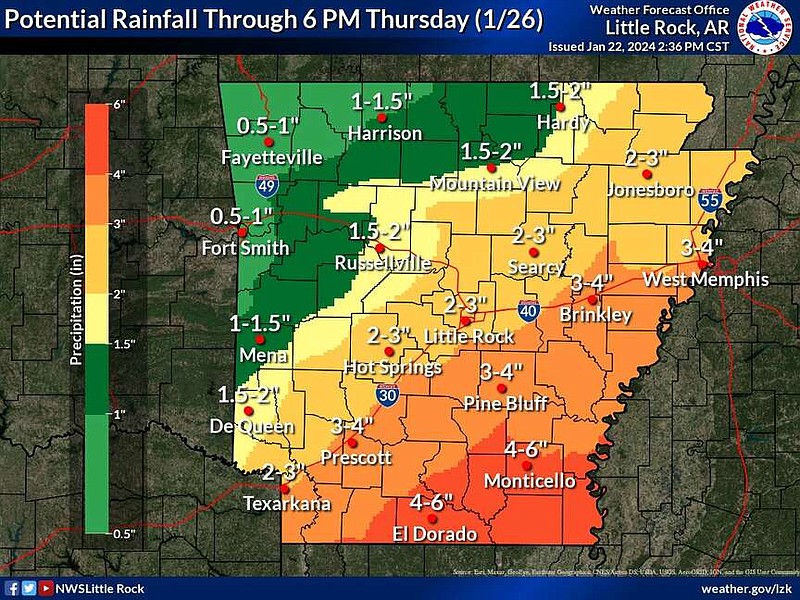
Parts of Central Arkansas could see anywhere from two to three inches of rain through Thursday, the weather service said in a post on X on Monday just before 3 p.m.
"We're pretty confident that Little Rock will likely see the upper end of that range, closer to three or maybe hitting four inches of rain," Cooper said Monday.
The briefing said that parts of southern and western Arkansas, including Hot Springs, De Queen, Prescott and Texarkana, could see up to six inches of rain. Parts of Northwest Arkansas are expected to see the least precipitation with the event.
The first wave of rain is set to move through on Tuesday and slow down by dawn on Wednesday, Cooper said. Lingering rain will remain across Arkansas until heavier rain will move in closer to the end of the week.
"The good thing is that all that rain is not going to happen over just one day," he said.
Cooper said there is not a concern for severe weather like strong winds or hail with this rain.
"There will be thunder, but not any especially strong winds that would spin or blow things away," he said.
He did say there was some potential for flooding despite lingering drought conditions in the parts of state, due to various environmental factors.
"Going against us we have the fact that a lot of vegetation is dormant because it is winter. It isn't soaking up as much as water. Then, there's the fact that we don't really have a break between the freezing rain today and the start of heavy rain tomorrow," Cooper said.
"And while it is not as cold as it was, the soil is still cold and it might not infiltrate the soil as easily which will lead to runoff. Runoff is where flooding becomes a concern," he said.
The forecaster said that southeastern Arkansas had the most risk for flooding.
Much of Arkansas, especially the eastern half, is under varying degrees of drought conditions, according to the U.S. Drought Monitor map on Monday afternoon.
Southeastern parts of the state are shown to experience extreme drought conditions while much of the state is experiencing moderate drought or abnormally dry conditions, the map showed.
Extreme drought means that: "pastures are depleted; hay is short; cattle are sold; there are more insects than normal; trees show drought stress; wildlife seek food and water; there is not enough water to fight fires; water shortages are noted; water table is low; stock ponds are dry," the monitor says.
"The ground wants the water, the question will be if the rain will move slow enough to let i soak in," Cooper said.
With the rain, the state is expected to see temperatures above freezing, he said. Little Rock could see highs in or near the 60s as early as Tuesday and more certainly by Wednesday and Thursday.
"It is going to warm up a bit and then kind of sink back down, closer to seasonally cool air and closer to expected temperatures for Arkansas in winter," Cooper said.
The freezing rain in the state on Monday morning is expected to fully transition to rain by the afternoon, the briefing said.
"It was definitely the worst in the west, maybe northwest third to half of the state," Cooper said. "It doesn't appear we saw most of the ice storm impacts that we could have, like power outages. It was likely that there not being a lot of wind helped with that."
"It's not as easy to track accumulation amounts for freezing rain as it is snow," he said.
The River Valley area, near Clarksville, Russellville and Fort Smith got the most of the freezing rain accumulation, he said. Amount totals were closer to a quarter of an inch to half an inch.
In Central Arkansas, accumulation was closer to a tenth of an inch, he said.
ROAD CONDITIONS
Roads in the Little Rock Metro area are in good condition Monday morning, Arkansas Department of Transportation spokesman Dave Parker said.
An online map from the Arkansas Department of Transportation showed that most major roads in the Metro area were clear of winter weather on Monday just before 11 a.m.
"We spent all yesterday pretreating the roads with a salt brine and then we placed rock salt this morning," Parker said.
He said the rock salt can lower the freezing temperature of the rain from 32 degrees to 25 or 26 degrees.
"Central Arkansas is looking pretty good, this event was mostly isolated to portions of Northwest Arkansas, really on Interstate 40 near and the River Valley," Parker said.
He said the freezing rain made roads slick and there were a few minor accidents along I-40.
The online map showed that roads in much of the northwest portion of Arkansas were coated with ice, ice patches or slush as of Monday morning.
"This is kind of what we felt we'd get with the forecasts and all," Parker said.
He said that freezing rain is more difficult to handle than snow.
"It's a little tougher because you can see snow and you can plow snow, for freezing rain it can fall and stick to everything it touches, like tree limbs, cars and bridges, and it can look clear and then suddenly drivers have to deal with black ice," Parker said.
Rock salt also takes a little time to activate, he said, adding that it had to mix with the rain to prevent it from freezing as quickly.
Parker said that the department was now preparing for much of the state to receive rain this week.
"Now we're working on preparing for that rain in case it floods, replenishing our salt supply and repairing our equipment," he said. "We still have at least five good weeks of winter left."
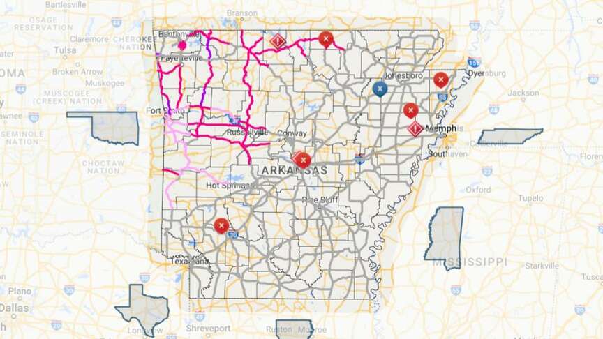 This screenshot shows an online map from the Arkansas Department of Transportation that highlights road conditions pertaining to winter weather throughout the state. The graphic shows road conditions on Monday, Jan. 22, 2024 just before 11 a.m. (Arkansas Department of Transportation)