6:45 P.M. UPDATE
The National Weather Service in North Little Rock issued a tornado watch for 47 counties in Arkansas from around 6:40 p.m. Friday to 2 a.m. Saturday.
The list of counties includes: Conway, Faulkner, Garland, Grant, Lonoke, Perry, Pope, Prairie, Pulaski, Saline, White, Yell, Jackson, Monroe, Woodruff, Baxter, Boone, Cleburne, Fulton, Independence, Izard, Marion, Newton, Searcy, Sharp, Stone, Van Buren, Lawrence, Randolph, Arkansas, Bradley, Cleveland, Desha, Drew, Jefferson, Lincoln, Calhoun, Clark, Dallas, Hot Spring, Ouachita, Pike, Johnson, Logan, Montgomery, Polk and Scott.
3:45 P.M. UPDATE:
Arkansas is bracing for two rounds of thunderstorms that are expected to bring strong winds and possible tornadoes, a meteorologist with the National Weather Service said.
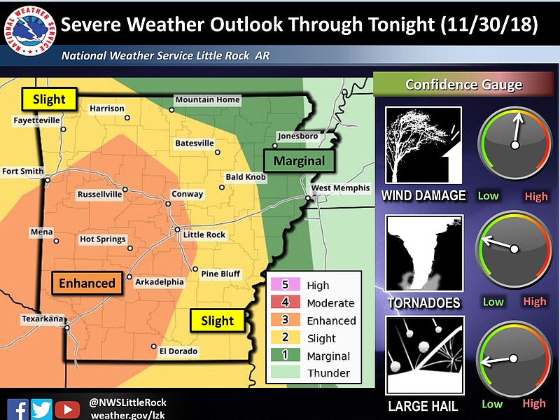
Dennis Cavanaugh, a meteorologist with the agency's office in North Little Rock, said he expects the storms to start from about 3 to 6 p.m., hitting west central and southwest Arkansas with the most severity.
The second round of storms should begin at about midnight, moving in from the west, Cavanaugh said.
Cavanaugh thinks much of Arkansas will be placed under a tornado watch this afternoon.
Structures that are poorly built and mobile homes are particularly at risk during tornados, Cavanaugh said.
“In all likelihood the tornado won’t hit you, but it’s better to be in the shelter and be safe than be sitting in the living room and something hit you,” Cavanaugh said.
Cavanaugh predicts that the most rain will fall in central and northeast Arkansas, putting those areas at the most risk for flash floods. There is a small chance of hail throughout the storms but a real possibility that many Arkansans will lose their power.
The Arkansas Department of Emergency Management has set up two on-call shifts that can respond in the case of extreme weather, said Dan Noble, a spokeman for the department.
“We don’t take this step unless there is a significant chance for severe weather and for people to be affected,” Noble said.
EARLIER:
A large part of Arkansas is at risk for severe thunderstorms, including damaging winds and possible tornadoes, on Friday evening, a meteorologist with the National Weather Service said.
Tabitha Clarke, a forecaster with the agency's office in North Little Rock, said she expects the storms to start about 8 p.m. and continue through 4 a.m., hitting west central and southwest Arkansas with the most severity.
“The biggest threat with these will be damaging winds,” Clarke said, noting the risk for tornadoes is smaller.
She said she estimates the winds to reach 60 mph and anticipates areas may receive as much as 2 to 3 inches of rain.
“We do have quite a bit of rain with this,” Clarke said.
To prepare for the rain, the Arkansas Department of Transportation is cleaning out drainage areas to try to prevent flooding, said Danny Straessle, the group’s spokesman.
Department officials are also keeping an eye on roads that typically flood, keeping a crew on call to respond if needed, Straessle said.
Highways in northeast and southeast Arkansas are particularly vulnerable to flooding, he said.
“It’s Friday but it’s not a lazy Friday to be sure,” Straessle said.
Because of the weather, the Arkansas Activities Association postponed the night's slate of playoff games, including the Class 5A championship.