UPDATED: 7:25p.m.
A wave of winter weather swept across Arkansas Sunday, bringing with it several inches of show and the coldest temperatures the state’s seen since January 2021.
By Sunday evening, the temperature in Central Arkansas had plummeted to 14 degrees Farenheit, with equally cold weather forecast for Monday and even colder temperatures forecast for Tuesday.
With cold air in place, snow is expected through Monday across much of Northern and Central Arkansas, according to the National Weather Service. Southern Arkansas will likely see sleet, but could see snow as well.
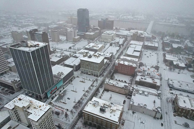
As of Sunday evening, the greatest forecast snow totals are expected from Central to East-Central Arkansas, with four to six inches possible.
Portions of Northern Arkansas will see slightly less accumulation, but some areas still might receive upwards of four or more inches.
A Winter Storm Warning is in effect through Monday at 6 p.m. across most of Arkansas. In addition to the Winter Storm Warning, Wind Chill Advisories are in place for much of the state through at least Tuesday.
By Sunday evening, the Arkansas State Emergency Operations Center, which is part of the Arkansas Department of Emergency Management, was at Level I activation. The Arkansas Department of Emergency Management is collaborating with Arkansas State Police, the Arkansas Department of Transportation, the Arkansas National Guard, the National Weather Service out of Little Rock, and other emergency support function personnel to assist with weather-related operations.
“I have joined my team here in the SEOC, and we will remain here for the duration. Our top priority is to be ready if something serious happens,” A.J. Gary, Director of the Arkansas Department of Public Safety, stated in a press release.
As of late Sunday, the winter storm had already affected area businesses and services as well as power availability and travel across the state.
The University of Arkansas for Medical Sciences declared an inclement weather policy for its main campus in Little Rock Sunday night through Monday morning, meaning non-critical campus areas were closed.
As of 5:30 p.m. Sunday, Entergy Arkansas reported 63 customers without power in the Pine Bluff area and 275 without power around Russellville.
At 3:30 p.m., the Arkansas Department of Transportation’s IDriveArkansas website reported four traffic accidents.
The first occurred at 2:58 p.m. in the eastbound lane of Interstate 30 at Exit 142.
A second took place at 3:20 p.m. in the southbound lane of Interstate 430 at mile marker 11.2.
ARDOT reported an accident in Crawford County at 3:23 p.m. near Mulberry at Exit 20.
And at 3:28 p.m., an accident was reported in Prairie County at mile marker 203, four miles west of Hazen on a section of highway that was reported as being covered in slush.
Three more accident were reported across the state after 3:44 p.m.
On Sunday afternoon, the West Fork Police Department posted on social media that “Highway 71 and all side roads are covered and slick. There are currently no wreckers available in our area due to high call volume. Please stay home.”
The Little Rock Zoo announced at 2 p.m. it was closed for the rest of the day and would remain closed through Tuesday due to the freezing temperatures.
After the overnight hours, National Weather Service forecaster Dylan Cooper expected attention to turn to the area south of the Interstate 40 corridor.
“We do expect a fairly heavy band as snow to develop overnight into Monday morning and maybe even persisting into Monday afternoon,” said Cooper. “That’s where we expect to see the highest accumulations with this. And we’re talking pretty good shot of getting four to five inches in that area.”
“Depending on the strength of the circulation that’s driving that there’s not really any way to simplify that, but depending on how strong that is. We could see some areas pick up in excess of six inches. So our confidence in seeing heavy snow in that area is pretty high. But as far as how much snow, we don’t have a whole lot of confidence at this point. Bottom line when it comes to the snow, sleet, whatever precipitation we get in a state that is going to make very hazardous travel conditions. We would not recommend that anybody get out on the road.”
By Tuesday morning, Cooper said that almost the entire state would likely see below zero windchills.
“That’s a fairly rare thing for us to see over the entire state of Arkansas, but that is really our biggest concern,” Cooper said. “The more difficult thing is is protecting from the cold itself. Our coldest areas, anybody that’s outside could get frostbite and as well as a half hour with the kind of windchill’s that we were not just forecasting, but what we’ve already seen. And in addition to that, folks that don’t have access to adequate shelter are going to experience significant physical distress hypothermia, potentially even death.”
UDPATED: 11:15a.m.
The National Weather Service has issued a winter storm warning that will go into effect Sunday, along with a wind chill warning and advisory that are already in place, the weather service said.
A winter storm warning is set to go into effect at noon on Sunday and last until 6 p.m. on Monday for most of Arkansas, excluding Benton County, the weather service said in a winter weather briefing Sunday morning.
“Once cold air is firmly in place, snow is expected to begin Sunday afternoon and continue into Monday across much of northern and central Arkansas. Southern Arkansas will likely see some snow but could see sleet as well,” the briefing said.
The greatest potential for snow is in Central Arkansas, with four to five inches of snow forecast through Monday night, and totals may be greater locally, the weather service said.
There is a chance that a portion of central eastern Arkansas could see more snow than that, but the bands of heavier snow could shift in location.
The rest of the state can expect a widespread two to three inches of snow, according to the forecast.
Travel impacts, including slippery roads and reduced visibility, will be possible where snowfall occurs, the weather service said.
Gov. Sarah Huckabee Sanders activated the National Guard winter weather support teams in order to provide support to the Arkansas State Police, a news release from the National Guard said late Sunday night.
Nine state police troops will be supported by two winter weather truck teams and three troops will receive aid from four teams, the release said.
“Each team consists of four truck operators and a supervisor for a total of five personnel per team,” the release said. The teams will provide support in 12-hour shifts until they are no longer needed.
“Teams are not authorized to recover privately owned or commercial vehicles. However, if the need arises, teams are permitted to recover first responder emergency vehicles and transport stranded motorists to safety,” the release said.
168 guardsmen will be on orders and 60 Humvees or trucks will be used to support the state police, the release said.
Further adjustments to the forecast are still possible, the weather service said.
A wind chill advisory is in place for much of the state, including Little Rock, Jonesboro, Hot Springs, Pine Bluff, Fort Smith and Fayetteville, through Tuesday, at least, the briefing said.
“Bitterly cold temperatures, much below climatological averages, are likely through mid-week,” the briefing said. Most of the state will not see high temperatures above freezing until Wednesday at the earliest.
On Monday morning, Little Rock is forecast to see a low of 12 degrees with a wind chill of one degree, the weather service said.
Statewide, low temperatures on Monday will range from single digits mostly in northern and northwestern Arkansas to teens in the southern and central areas, forecasters said.
Temperatures will continue to drop on Tuesday, with all but parts of southern Arkansas forecast to see lows in the single digits, the briefing said. Wind chills for most of the state will be in the negatives.
On Wednesday morning, all of Arkansas is currently forecast to see single digit temperatures with wind chill values forecast to be zero or below, the weather service said.
--
The latest forecasts from the National Weather Service show that most of Arkansas can expect snow and very low temperatures from Sunday through Monday.
Most of the state, excluding some parts of Northwest Arkansas, will be under a winter storm warning, the National Weather Service said Saturday. The warning will be in effect from noon Sunday until 6 p.m. Monday.
Heavy snow is expected, with snowfall accumulation between 2 and 5 inches possible, with locally higher amounts.
"With Arctic air firmly in place before and after the winter weather arrives, impacts from snowfall will last for several days, resulting in a prolonged period of hazardous travel conditions," the weather service said Saturday.
The weather service changed the winter storm warning criteria in November.
A wind chill advisory is set to be in place until noon on Tuesday for much of Arkansas, including Little Rock.
When wind chill index values reach zero degrees for several hours over a fairly large area with a wind speed of at least 10 mph, the weather service will usually issue a wind chill advisory, the service's website said.
"Bitter cold wind chills could result in frostbite as well as significant impacts to infrastructure," the weather service said in the advisory.
Northern Arkansas is set to see somewhere between 2 and 4 inches of snow, and some southern parts of the state could see between an inch and 3 inches, the weather service said.
While adjustments may still be made to the forecast, most of Central Arkansas is set to see anywhere from 3 to 5 inches of snow. Some areas, including Pine Bluff and Brinkley, could possibly see 6 inches or more, the briefing said.
"The Little Rock metro area is really forecast to see between 4 and 6 inches of snow," said Joe Goudsward, a forecaster with the National Weather Service office in North Little Rock.
Goudsward also said there is an isolated band that may have more snow, but it is currently south of the city.
"There is this narrow band forecast to see closer to 7 or 9 inches of snow," Goudsward said Saturday afternoon. "If that moves, then there is a chance that Little Rock could see more snow than currently forecast."
"While small, there is some chance snow amounts will approach or exceed 10 inches," the briefing said.
According to the winter storm severity index, most of Arkansas, excluding Northwest and some southern portions of the state, will experience moderate effects due to the snow.
Arkansans in areas with a moderate impact rating, including Searcy, Mena, Fort Smith, Russellville, Camden and Monticello, can expect disruptions to daily life, the weather service said. Hazardous driving conditions could be present, and closures or disruptions to infrastructure may occur.
Some parts of Arkansas, including Little Rock and Pine Bluff, can expect considerable disruptions to daily life, according to the severity index. Dangerous or impossible driving conditions might be present as well as widespread closures.
Goudsward said roads will be covered in snow and possibly slippery.
"[The state Department of Transportation] is doing the best they can by treating the roads right now," he said. "But there is going to be snow. Work from home. Stay home if you can. Staying in and hunkering down and staying put until this event is over is ideal."
He said that the snow should start moving into Northwest Arkansas between 4 p.m. and 5 p.m. on Sunday, and it should be in the Little Rock metro area after dark, closer to 6 p.m.
The University of Arkansas at Monticello has already closed its campus on Tuesday due to inclement weather, the university said in a news release on Saturday. It will reopen on Wednesday.
The city of Little Rock has postponed the city's Dr. Martin Luther King Jr. Unity Service, previously scheduled for Sunday at 5 p.m., due to inclement weather.
"The service will be rescheduled for a later date and details will be announced soon," the city said in a post on social media Friday afternoon.
DANGEROUSLY COLD TEMPERATURES
On Sunday, low temperatures across the state are forecast to be between the single digits and the lower 20s, the briefing said.
"I would call this dangerously cold," Goudsward said.
Little Rock's forecast low is 13 degrees, with a wind chill of negative 1 degree. On Monday, temperatures are predicted to rise slightly with the city's low being 16 degrees and the wind chill being 1 degree, the weather service said.
Forecasters said Tuesday and Wednesday will be the coldest days in the upcoming week.
Little Rock is set to see a low of 6 degrees and a wind chill of negative 11 degrees on Tuesday, the briefing said. By Wednesday, the low is expected to be 4 degrees with a wind chill of negative 4 degrees.
The forecaster said that if an area gets a lot of snow, temperatures could be even colder.
"Snow can actually reflect the sun away, and that means less heat is absorbed, which will keep things cooler," he said.
Goudsward said Arkansans should consider dressing in layers, including hats, scarves and gloves.
"If you have outdoor pipes, you need to cover them and let your faucets drip," the forecaster said.
WARMING CENTERS
The city of Little Rock announced Friday that it would open a 24-hour emergency shelter today at 6 p.m.
"In anticipation of bitterly cold weather and the likelihood of winter precipitation, the City of Little Rock will open a 24-hour emergency shelter at the East Little Rock Community Center starting Saturday evening," the city said in a news release.
The shelter, located at 2500 E. Sixth St., will be operated by The Van, a Little Rock-based nonprofit. Individuals in need of transportation to the shelter can request it by calling (501) 955-3444.
"The city has a full supply of sand and salt mixture if needed for city streets, and both large and small trucks are fitted with spreaders and plows," the release said.
Conway has opened three locations that can serve as warming centers, the city said in a Facebook post on Wednesday afternoon.
Don Owens Sports Center, 10 Lower Ridge Road, was scheduled to open 24/7 starting today. The center can be reached by calling (501) 450-6186.
The McGee Center, 3800 College Ave., will be open from 7 a.m. to 9 p.m. on Tuesday through Jan. 20, and from 1 p.m. to 6 p.m. Jan. 21. The center will be closed on Monday for Martin Luther King Jr. Day. The center can be reached at (501) 513-3586.
Conway Emergency Shelter, 1116 Gum St., is open 24/7, with check-in from 3:30 p.m. to 6:30 p.m.. Anyone 18 or older will be served on a first come, first-served basis.
No pets are allowed at any of the three warming centers in Conway.
In North Little Rock, a warming center at the North Little Rock Community Center, 2700 North Willow St., will be open from today at 4 p.m. until 7 a.m. Wednesday, the city said in a post on Facebook on Thursday afternoon.
Those at the warming center are encouraged to bring their own food, drinks and entertainment. Vending machines will be available.
Pets are allowed at the North Little Rock center.
The Arkansas Department of Emergency management compiled a list of warming centers around the state in an online map.
COLD TO CONTINUE
"High temperatures on Thursday should finally climb above freezing across all of the state of Arkansas," the briefing said.
"We won't be warm by any means, but warming for a bit. But, late next week we are looking at another burst of cold," Goudsward said.
The forecaster said that there is not a lot of snow expected with that weather event.
"It will be cold, though, so Arkansans should be ready to be cold for a while," he said.