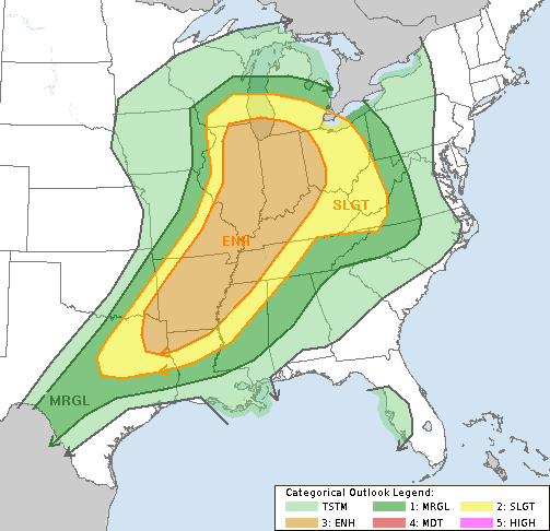
Most of Arkansas is under an enhanced threat for severe storms Thursday as a cold front moves in and brings with it the possibility of large hail, damaging winds and tornadoes, the National Weather Service said.
All but Northwest Arkansas is under the enhanced risk rating, which falls between slight and moderate and signifies the possibility of numerous severe storms.
The weather service said the cold front will approach and meet up with "warm and moist air ... along with a substantial amount of wind energy," fueling thunderstorms that could turn strong to severe.
The storms are expected to begin in the northwest half of Arkansas between 4 p.m. and 7 p.m., the weather service said in a statement, before spreading south and east across the rest of the state.
"Storms that become severe will be capable of producing damaging straight line winds, large hail and isolated tornadoes," the statement said. "There will be a lot of moisture available, which will make storms more efficient rainmakers. One to two inch amounts are possible south of Little Rock."
The weather service reported probabilities of tornadoes in Arkansas at 2 percent or 5 percent for different parts of the state. Chances for damaging winds were pegged at 30 percent for most of the state, while the probability of large hail was said to be 15 percent. Click here for graphics detailing the storm timing and risks.
While Northwest Arkansas isn't under the enhanced risk for storms, parts of it are under a slight or a marginal risk.
The cold front will move south from Arkansas on Friday, but will return two days later, bringing chances for more storms Sunday night and Monday, the statement said.
The latest round of storms comes after tornadoes were reported Wednesday and Thursday in Kansas, Missouri and Oklahoma, though minimal damage was reported.
Meteorologists and emergency managers from the high Plains to the Appalachians were on alert as the U.S. had the year's first widespread bout of severe weather. The key message: Have a plan.
"Where to hide, emergency kits with medicines, snacks, water. Even something like sturdy shoes, gloves, long-sleeve shirts. If they get hit by a tornado they'll find they'll need those things pretty quickly," said meteorologist Erin Maxwell with the National Weather Service in Norman, Okla.
"Know what you're doing, and just don't panic," Maxwell added.
Severe thunderstorms packing 70 mph winds and large hail made their way across central Missouri on Wednesday afternoon, including several capable of producing tornadoes.
Weather spotters reported a funnel cloud near Potosi in eastern Missouri at 3:35 p.m., while an hour earlier the Bates County emergency manager reported a tornado in southwest Missouri that destroyed a 60-foot machine shop.
Indiana State Police said high winds toppled a tractor-trailer on Interstate 69 near Evansville, while utilities reported a number of power outages after wind gusts reached 70 mph. Authorities in Hendricks County, west of Indianapolis, blamed a 75-year-old woman's death on flash flooding.
The Associated Press contributed to this story