In a 24-hour period in June, a traffic engineering consulting firm counted 19,600 vehicles passing through the intersection at East Second and Cumberland streets in downtown Little Rock.
Of those, 7,800 went north onto Cumberland toward LaHarpe Boulevard, where they likely continued onto LaHarpe, also called Arkansas 10, and to points west, according to the report from The Traffic Group Inc. of Baltimore, which has a contract to count vehicles for the Arkansas Highway and Transportation Department.
Of those 7,800, about 6,700 turned north onto Cumberland from one of the two off-ramps from Interstate 30.
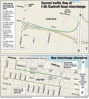
Under an option that state engineers and their consultants are considering to redesign that downtown interstate interchange, most of those vehicles would travel from the I-30 exit ramps west onto Second Street.
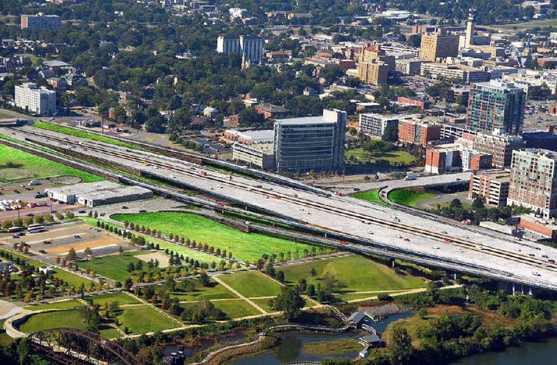
The work is part of a $600 million project to address the aging, congested 6.7 miles of the I-30 corridor through downtown Little Rock and North Little Rock.
The proposed redesign would funnel the traffic away from LaHarpe Boulevard, which would be closed to through traffic at President Clinton Avenue.
The Second/Fourth street option was an idea pushed by, among others, City Director Dean Kumpuris, who wants to protect the vibrancy of the downtown River Market entertainment district, which borders the west side of the interstate near the Arkansas River.
"Everybody's got the same problem," he said at a presentation on the project last week during a city board meeting. "That is, 'how do you make these changes without ruining what some of the people in this room have spent a good part of their lives building?'"
The answer might not be Second Street, though.
"The county judge doesn't like it," Kumpuris said. "The people on the street don't like it."
Already, according to the traffic count that was taken on June 2 and June 3, more than 3,800 vehicles travel west on Second Street from the intersection.
If LaHarpe is closed to through traffic, as is contemplated, an additional 6,700 vehicles likely would shift to Second Street, for a total of 10,500, judging from the June traffic count.
That traffic would go nine blocks -- through at least eight traffic signals, past the Capital Hotel, an E-Stem Public Charter School campus, the Stephens Inc. building, the Pulaski County Courthouse, and other businesses and institutions -- before turning right onto State Street to travel two more blocks north before reaching LaHarpe.
Traffic that now uses LaHarpe to access I-30 instead would be steered onto Chester Street, which is two blocks west of State Street. The vehicles would travel south for four blocks to Fourth Street and then east for 11 blocks to Cumberland, turn north onto Cumberland for a block and then get onto the interstate.
Much of the traffic passing through the intersection is during a two-hour period beginning at 7 a.m. each day of the workweek. The Traffic Group counted 3,405 vehicles, or 17 percent, going through the intersection between 7 a.m. and 9 a.m.
Given the increased amount of traffic and the additional traffic signals under the Second and Fourth street alternative, Second Street would be widened to three lanes to handle the peak morning volume. Still, engineers say, it will take longer to travel the alternative route than it would to take LaHarpe.
Critics of the plan also complain that it would take away street parking along Second Street that customers of area businesses use, and would introduce more pedestrian-vehicle conflicts than leaving LaHarpe available for through traffic.
"The most concern I've heard expressed is the dumping of a large amount of traffic on West Second," said City Director Gene Fortson.
Little Rock officials and others, including Kumpuris, sought to steer traffic away from the River Market District, an otherwise pedestrian-friendly area of restaurants and bars.
They have called the intersection of Cumberland and East Markham Street/President Clinton Avenue, one block north of Second Street, as one of the most dangerous in the region.
Metroplan, the long-range transportation planning agency for central Arkansas, has said the intersection is one of a dozen in the region that's targeted for improvement on the basis of a 2012 analysis of pedestrian and bicycle crashes in central Arkansas.
The regional analysis found that 1,401 pedestrians and 512 bicyclists were involved in crashes with motor vehicles in Faulkner, Lonoke, Pulaski and Saline counties over a 10-year period that ended in 2010.
Those crashes cost the lives of 104 people, and $125 million in lost productivity and incurred expenses, according to the Metroplan analysis.
During the study period, there were nine crashes at Cumberland and Markham/President Clinton. One of the other dangerous intersections, Sixth Street and Broadway, had eight crashes.
Jerry Holder, a Garver LLC engineer who is the program manager for the state's $1.8 billion Connecting Arkansas Program -- of which the I-30 corridor project is a part -- promised to go back to the drawing board to devise another option that might get more support.
"We are going to lock ourselves in a room the week before Thanksgiving," Holder said. "There's going to be five or six of us, and we are going to scratch our heads on other options that we can come up with here.
"At the end of the day, it may be one of those things where you have to pick the one that gives you the least amount of problems and provides the most safety. I don't know what that is right now."
The Little Rock Regional Chamber of Commerce, after a meeting of its executive board, issued a statement Friday praising the I-30 corridor project.
"This overall design provides increased accessibility as well as safety for people traveling to and from the downtown area," the statement said. "We commend the Arkansas Highway and Transportation Department, and its design team coordinated by Garver Engineers, for developing a plan that improves traffic safety while not materially increasing the existing right-of-way for the corridor.
"We also commend them for being responsive to the many legitimate concerns that have been expressed by the public throughout the approximately 18 months of planning and community outreach that has already taken place."
But even the chamber held out hope that additional discussion will result in a more amicable alternative for the I-30/Arkansas 10 (Cantrell Road) interchange.
"We welcome the broad community interest and discussion about what is the best possible design that enhances our downtown business and residential climate, but also remembers the needs and safety of the thousands of citizens who commute to work every day into our downtown areas," the chamber said in the statement.
SundayMonday on 11/08/2015