Another dose of steady rain and isolated thunderstorms will hit Wednesday throughout the state, which is already wet from two days of precipitation, according to the National Weather Service in North Little Rock.
Meteorologists said they expect the next round of rain to move into central Arkansas by mid-morning Wednesday and continue off and on throughout the day. A break in the rain will occur in the evening before another batch of precipitation begins at daybreak Thursday.
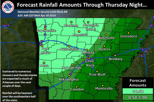
Residents in central Arkansas could see up to an inch of rain through Thursday afternoon, while another 2 inches could fall in the southern part of the state, according to the latest forecast.
Severe weather, though unlikely, is possible in southeast Arkansas.
"We may hear an occasional rumble of thunder, but the chance for severe storms is pretty low," meteorologist Charles Dalton said.
The National Weather Service issued a flash flood watch for nine counties in southwest Arkansas as residual storms from northeast Texas could bring heavy rainfall into that region.
The flash flood watch will be in effect until Thursday afternoon.
Clear and dry weather will return by Friday and last throughout the weekend, Dalton said. Temperatures will also rise into the lower 70s and upper 80s across the state.
A flash flood watch has been issued for the following counties:
Sevier
Howard
Little River
Hempstead
Nevada
Miller
Lafayette
Columbia
Union