UPDATE:
Isolated severe storms remain possible Wednesday, but the National Weather Service has reduced the risk level for much of the state.
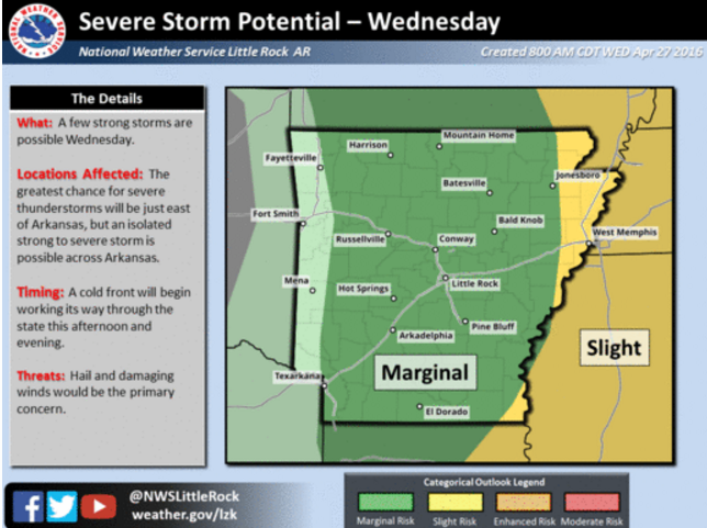
Most of Arkansas had been under a slight risk for severe weather in forecasts earlier Wednesday morning. An updated forecast placed only some parts of eastern Arkansas under a slight risk. A much larger part of the state was placed under a marginal risk for severe storms.
A slight risk calls for scattered severe storms with strong winds, large hail and one or two tornadoes. The lesser marginal risk calls for isolated severe storms with winds up to 60 mph, hail an inch or less in diameter and a low risk for tornadoes.
EARLIER:
A cold front moving across the state from Oklahoma Wednesday brings a risk for isolated severe storms to much of the state, the National Weather Service said.
"We're not really anticipating a lot of rain showers or thunderstorms to develop," said Jeff Hood, a weather service meteorologist in Little Rock. "But those [storms] that do develop have the potential to be severe."
The Storm Prediction Center said most of the state, with the exception of Northwest Arkansas and parts of western Arkansas, are under a slight risk for severe storms packing damaging winds and hail. The weather service said a "tornado or two is possible," but it's considered a lesser threat.
Hood said Wednesday's cold front is part of a larger system that moved across the Great Plains and Midwest Tuesday, affecting an area that stretched from central Texas to West Virginia, according to weather service reports.
Severe weather reports traced around the northwest corner of the state, downing power lines in Benton County and damaging a school roof in Washington County, according to the weather service.
Wednesday's storm was expected to move through the state after passing the Oklahoma border in the early afternoon, Hood said.
With temperatures warming later in the day, the greatest risk for the storm losing stability will occur as the front moves through eastern Arkansas, Hood said.
Where isolated storms do develop, quarter-sized hail and damaging winds topping out at 60 to 70 mph could be seen, Hood said.
"When there is some risk ... we're asking people to take it seriously," he said.