FRIDAY
12:20 a.m. UPDATE
At least 1 inch of snow is now blanketing Little Rock, hours after a wintry mix brought sleet and freezing rain to the region, according to the National Weather Service.
In certain areas, weather officials said sleet continues to mix in with snow. Wintry precipitation is set to continue through Friday morning, the weather service said.
Overnight, the winter storm could bring up to 4 inches of snow to Little Rock, according to the National Weather Service's latest forecast.
[CLICK HERE FOR A FULL LIST OF SCHOOL CLOSINGS]
The state Highway and Transportation Department reported roads in the metro area covered with snow as of about 12:20 a.m. Ice was reported in northeast Arkansas, including Jonesboro, at that time.
Areas south and east of Arkansas' capital city such as Pine Bluff could see up to 6 inches associated with the system, forecasters said. Remaining portions of the state are predicted to receive between 1 and 5 inches.
As of the midnight hour, more than 7,000 Entergy customers in Arkansas are without power, with more than 3,000 of those affected in Pulaski County.
Check back with ArkansasOnline for updates throughout the day Friday regarding travel conditions and other weather-related information.
— Brandon Riddle
THURSDAY
11:05 p.m. UPDATE
Most morning flights scheduled before 9 a.m. Friday at Bill and Hillary Clinton National Airport have been canceled, the Little Rock airport said on social media Thursday night.
Travelers are advised to check with their airline for details regarding flight cancellations.
Updated information regarding departing and arriving flights at Clinton National Airport can be found on the airport's website or by calling (501) 372-3439.
As of about 11 p.m. Thursday, Entergy Arkansas reported that more than 5,300 Arkansas residents were without power as a wintry mix continues to move across the state. Of that total, nearly 3,000 power failures were in Pulaski County.
Travel conditions at that time began to deteriorate in central Arkansas as slush and snow was reported on roads in the region, according to the state Highway and Transportation Department.
— Brandon Riddle
10:10 p.m. UPDATE
In Newport, a portion of U.S. 167 was covered in a sheet of ice as of about 9:58 p.m., according to a local report from the National Weather Service.
A number of residents were also in the dark as a result of ice in the area, the report stated.
According to Entergy Arkansas' outage map, more than 4,300 Arkansas residents were without power as of about 10:06 p.m.
Of that total, the highest amounts were reported in Craighead and Pulaski counties, both with more than 1,000 customers affected.
— Brandon Riddle
9:35 p.m. UPDATE
A wintry mix of freezing rain and sleet began to fall in parts of central Arkansas shortly before 9 p.m. Thursday, ahead of what forecasters predict will be heavy snowfall in eastern portions of the state, according to the National Weather Service.
Late Thursday and into overnight hours, the wintry mix is forecast to transition into snow for most of central, southern and eastern Arkansas. Snowfall will come to an end Friday morning, the weather service said.
Ice and slush was reported on roads in northeast and north-central Arkansas about 9:30 p.m. on the state Highway and Transportation Department's conditions map.
At that time, no wintry precipitation was reported on roads south of the Interstate 40 corridor, where residents could see heavier amounts of snow.
ArkansasOnline will continue to provide updates as the late-week winter storm continues to push through the state.
— Brandon Riddle
3:05 p.m. UPDATE
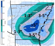
The latest National Weather Service forecast issued shortly after 2 p.m. shows all of the eastern half of Arkansas receiving at least 2 inches of snow by Friday morning.
Areas along the Mississippi River starting east of Pine Bluff and continuing north to the extreme northeast corner of the state could see the highest amounts of snow: between 6 and 8 inches.
The band of snow could produce between 4 to 6 inches of snow in cities such as Jonesboro, Pine Bluff and Monticello, forecasters said.
Snowfall totals are predicted to be lighter west of Little Rock, with 1 to 2 inches of snow possible in cities such as Texarkana, Hot Springs and Russellville, according to the weather service.
In a statement, meteorologist Christopher Buonanno said snow will begin mainly after midnight and will taper off by Friday morning.
Ahead of the winter storm, schools in the Little Rock area, where 2 to 4 inches of snow could fall, canceled afternoon events originally planned for Thursday.
A regular board meeting of the North Little Rock School District set for 5:30 p.m. has been rescheduled for 5:30 p.m. Monday, according to the district.
Earlier Thursday, Little Rock and North Little Rock schools announced the cancellation of after-school activities due to uncertainties in the precipitation's timeline.
The city of Little Rock said on Twitter that 16 trucks and more than 140 public works employees were preparing for wintry weather.
— Brandon Riddle
1:21 p.m. UPDATE
The National Weather Service in Little Rock on Thursday afternoon shifted the chance for heavier snow "a little" further to the south and east in Arkansas, hours before wintry precipitation is set to fall.
That shift could mean between 4 and 6 inches of snow falling in cities such as Pine Bluff and Monticello along a band that stretches northeast toward Memphis, the weather service said.
Cities in central Arkansas, including Little Rock, are now on the outskirts of the heaviest part of the snow band, with 2 to 4 inches predicted in Arkansas' capital city by Friday morning.
"Folks, snow is still in the forecast," the agency's Little Rock office said on Twitter shortly before 1 p.m.
Areas previously forecast to see snow will likely still see wintry precipitation, though in varying amounts depending on where the band will eventually lie, the weather service said.
A full forecast, as well as an updated graphic map depicting snow accumulation, is set to be released by the weather service later Thursday.
— Brandon Riddle
11:50 a.m. UPDATE
Wind gusts early Friday could cause power failure as late-week wintry precipitation comes to an end in the state, according to the National Weather Service in Little Rock.
Eastern Arkansas faces the greatest threat of being in the dark, with predicted wind gusts nearing 50 mph, forecasters said.
Wind gusts in areas further west in the state could see wind gusts between 20 to 30 mph, according to the weather service.
The National Weather Service's Memphis office has additionally placed eastern portions of the state in the possibility for near-blizzard conditions.
"North winds will increase to between 20 and 30 mph with gusts exceeding 40 mph," according to a weather statement. "This will combine with falling snowfall to produce periodic whiteout conditions across the warning area."
A winter storm warning is in effect for much of eastern and central Arkansas from 6 p.m. Thursday until noon Friday.
— Brandon Riddle
11:15 a.m UPDATE
Confidence is increasing that predicted snowfall amounts are in line with what Arkansans will likely see late Thursday through early Friday, according to a meteorologist with the National Weather Service in Little Rock.
The winter storm is set to bring 4 to 6 inches of snow to portions of Arkansas, including Little Rock, along a band that stretches northeast toward Jonesboro, the weather service said.
Outlying areas around the band, including Hot Springs and Pine Bluff, could see up to 4 inches. Forecasters say other areas of the state further west will likely see up to 2 inches of snow.
"Models that we are looking at are becoming more consistent," meteorologist Lance Pyle said. "With them agreeing, our confidence is going up."
Schools in the Little Rock area have put a halt on afternoon activities planned for Thursday, citing precipitation that is forecast to change from freezing rain to snow in the evening hours, continuing into Friday morning.
The Little Rock School District said in a statement that it has canceled or postponed planned athletic practices and games as a result of uncertain timing for the winter storm.
"Buses are scheduled to run their normal after-school routes; however, we will keep you informed should that change," the district said.
Thursday morning, the North Little Rock School District also said it has canceled all after-school activities originally planned.
Areas north and east of Little Rock, including Jonesboro, are set to receive up snow accumulations in similar amounts along the band of wintry weather, the weather service said.
The Jonesboro School District closed Thursday due to the threat of freezing rain and hazardous travel conditions.
— Brandon Riddle
9:40 a.m. UPDATE
LITTLE ROCK — A winter storm warning has been issued for the eastern half of Arkansas with forecasters predicting the potential for "significant snow accumulations" of up to six inches in addition to freezing rain and sleet.
The National Weather Service says the warning is in effect from 6 p.m. Thursday until noon Friday. A winter weather advisory has also been issued for much of western Arkansas.
The weather service says freezing rain and drizzle is expected Thursday, followed by sleet and snow and that strong winds could create blizzard-like conditions, making travel possibly very hazardous to impossible.
The precipitation is expected to end during the morning Friday.
— The Associated Press
7:08 a.m. UPDATE
An overnight storm with freezing rain made for slippery roadways and some school closures Thursday morning, and forecasters are predicting significant snowfall could be in store for tonight.
According to the Arkansas Highway and Transportation Department, most of the major highways in the central Arkansas were clear of ice. But some form of wintry precipitation covered routes in more northern counties, including Sharp, Independence and Fulton.
The exception in central Arkansas was U.S. 70 between Carlisle and North Little Rock, which was partly covered with slush Thursday morning, according to the highway department. Parts of Interstate 440 and Interstate 40 in the Conway area, meanwhile, were said to be mostly clear of slush.
Many smaller roads in Little Rock, including the 3rd Street bridge near the Arkansas State Capitol, were coated in a thin layer of slush early Thursday.
Meanwhile, forecasters raised their predictions overnight on the amount of snowfall a second storm could bring to the area tonight and Friday.
A Winter Storm Warning will be in effect for most of the eastern half of the state beginning at 6 p.m. Thursday. A swath of Arkansas beginning in Little Rock and heading northeast to Jonesboro could receive between 4 to 6 inches of snow, according to the National Weather Service.
Check back for updates.
— John Moritz
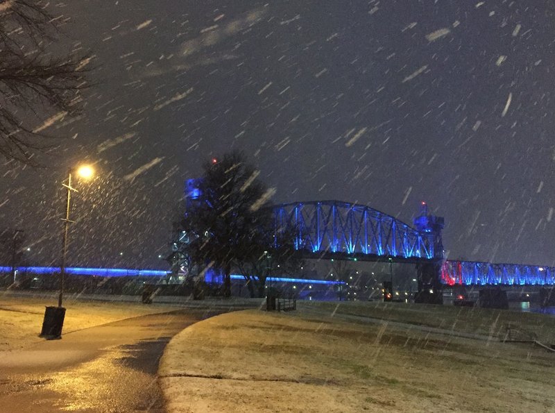
View from President Clinton Avenue. #ArkDG #ARwx pic.twitter.com/eDGA8WbDyL
— Brandon Riddle (@BrandonCRiddle) January 22, 2016
Snow is now falling in the River Market. #ArkDG #ARwx pic.twitter.com/5nc1Uo5BG7
— Brandon Riddle (@BrandonCRiddle) January 22, 2016