The dead-tree version of the Arkansas State Highway Map is bowing to the realities of the digital age.
Beginning this year, the Arkansas Highway and Transportation Department will print 500,000 paper maps, half of what has been its annual production for the past 10 years. And starting next year, the department will update the maps once every two years instead of annually, as it does now.
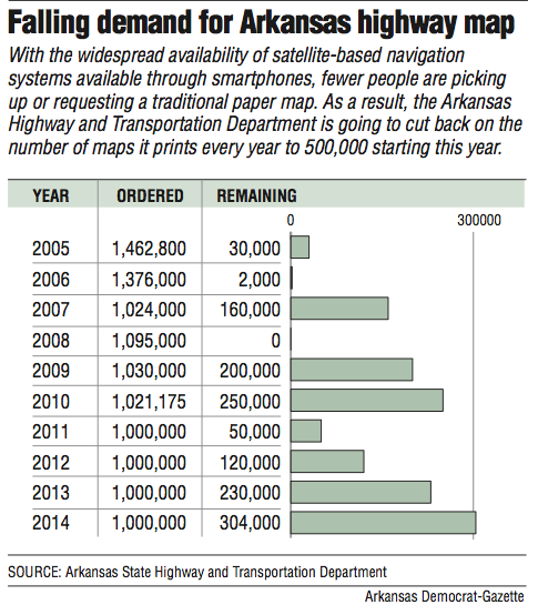
With satellite-based navigation systems available on smartphones and in many vehicles, demand for the paper maps is falling. Of the 1 million maps the department printed in 2014, the latest year for which the information is available, the department has more than 300,000 left.
The changes will more closely align production with demand, department officials said.
It is a bittersweet change for Sharon Hawkins and her staff. She heads up the agency's geographic information systems and mapping section. The 11-person staff produces 500 different maps every year, but the state map is the most widely known product.
"A part of me realizes the technology that people have in the palm of their hands now can guide them to where they want to go," Hawkins said. "But a part of me is sad because you can't see the big picture without a map and we are losing the art of looking at a paper-generated map. It's a mixed feeling."
Even the paper map has been generated by computer since 2002, and it's available for viewing on the department's website. The website also contains other maps for the agency and others. They include detailed county maps, city maps, route maps and maps that show traffic volumes.
Printed versions of those maps are sold through the department's reprographics section headed by Don Young. The section sells about 10 county maps a month and another five state highway wall maps a month, Young said. The wall maps are bigger than the regular highway map.
The state maps are available for free upon request, but they are typically found in state tourism information centers around the state. They also are distributed through vacation travel kits available upon request through the Arkansas Department of Parks and Tourism.
The savings by printing fewer maps won't make an appreciable difference on the department's bottom line, officials said. Last year's printing run cost about $110,000, or 11 cents per map.
Ten years ago, demand was so great for the highway map that only 30,000 were left out of 1.4 million printed, according to department distribution records.
The next year, 2,000 were left from a print run of more than 1.3 million.
The state ran out of the 2008 edition when 1 million were printed. But Hawkins said distribution that year was aided by a study in which contractors stopped motorists to survey where they were beginning and ending their trips. Each motorist surveyed received a state map, she said.
The demand also may have been fueled by an unusually high number of requests for maps from schools, Hawkins said.
But the backlog has been building in recent years. About 120,000 were left after 2012 and 230,000 in 2013. In 2014, the department had 304,000 left over.
Information on the backlog for last year's printing run, also 1 million, isn't available yet.
One of the problems the department will avoid in limiting changes to the maps to every two years is the timing associated with a change in governors. Each map has a photograph of the governor as well as a statement from the governor.
When the governor's office changes hands, there is a delay in getting the map ready for production, according to department officials. That leaves some maps available for as little as 11 months and as long as 14 months.
The department's new contract will have a provision to print additional maps in increments of 100,000 if demand requires it.
Even satellite-based navigation can't be relied upon every time, officials said.
A recent banner year was 2011, when 50,000 maps were left from a print run of 1 million. Young attributed the demand to heavy flooding in parts of the state as people scrambled to get information on detours around high water.
"GPS doesn't do well with detours," Young said.
Metro on 05/09/2016