As frigid temperatures settle into Arkansas over the next several days, cities are opening centers to help keep residents warm.
Four warming centers in Little Rock will be open Wednesday through Friday as well as Jan. 2 and Jan. 3, according to a news release. Hours are tentatively 9 a.m. to 6 p.m. on those days.
The city of Little Rock advises that residents can get out of the cold at the following locations:
• Dunbar Community Center, 1001 W. 16th St.
• East Little Rock Community Center, 2500 E. 6th St.
• Southwest Community Center, 6401 Baseline Road
• West Central Community Center, 4521 John Barrow Road
Emergency shelters will also be open at Second Baptist Church, 222 E. 8th St. in Little Rock, and Levy Church of Christ, 5124 Camp Robinson Road in North Little Rock, nightly Tuesday through Thursday.
In Conway, a winter warming station at will be available nightly from 7 p.m. to 7 a.m. through Feb. 28 at the Conway Ministry Center, 766 Harkrider St., when temperatures are at or below 40 degrees.
Low temperatures Tuesday are expected to be in the mid-to-upper 20s in central Arkansas. A light wintry mix of precipitation is possible over southern Arkansas overnight and into early Wednesday.
No travel problems are anticipated “as surface temperatures are only expected to be sub-freezing for a very short time before rain tapers off,” according to the National Weather Service in North Little Rock.
Highs are expected to be in the mid 30s to low 40s across the state through the end of the week. Lows are forecast to be in the low to upper 20s.
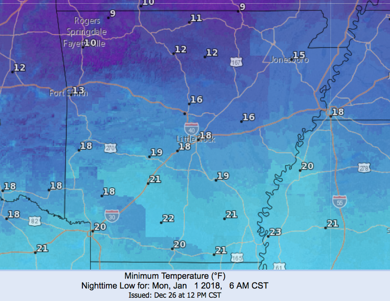
A strong blast of Arctic air is set to enter Arkansas this weekend, bringing lows potentially in the teens and single digits Sunday and Monday, forecasters said.
Wind chill values are forecast to be between 0 and 5 below going into New Year's Day in Northwest Arkansas. Highs on New Year's Eve are set to be in the mid 20s to upper 30s across the state. Monday's highs will likely been in the 20s.
Forecasters say that wintry precipitation, while unlikely, is possible late Saturday into Sunday in the state. “Confidence is low in this occurring,” according to the latest advisory.
“It would be advisable to monitor the forecasts in the next few days because if it were to occur it may be fairly widespread,” the outlook reads in part.
On Tuesday afternoon, the weather service said one model had a mix of freezing rain, sleet and snow falling between Saturday night into Sunday evening, resulting in some potential "significant issues for Arkansas" during a busy holiday traveling period.
Up to three-quarters of an inch of wintry precipitation was included in that model run.
The weather service said at that time that it was keeping the weekend forecast dry apart from isolated rain showers Saturday in southern Arkansas.