HUNTSVILLE -- For 19 days in January and February, five airplanes flew 19,000 feet above Arkansas, shooting 30,066 digital images of the entire state's terrain.
Those images, which encoded latitudinal and longitudinal coordinates, have been woven into a detailed digital map of the state.
Gov. Asa Hutchinson announced completion of the yearlong, $1.2 million mapping project Wednesday in the hallway of the Madison County Courthouse in Huntsville.
He said the benefits are at least two-pronged: Emergency responders will have more up-to-date information, and accurate digital mapping is essential for economic development.
"The face of Arkansas is changing rapidly," Hutchinson said in a news release. "Counties all over the state are building new roads, widening existing highways, adding businesses, homes and developing entirely new neighborhoods. Having an up-to-date detailed map of our state is a key tool for economic development and expanding infrastructure as our state continues to grow."
"If we do not have accurate information, then we're not going to be competitive in economic development," Hutchinson said during the news conference.
The project was initiated by the Arkansas Geographic Information Systems in late 2016. The digital maps are available online at gis.arkansas.gov. The public can access "2017 aerial imagery" by first going to "maps," then clicking on "map viewer."
Shelby Johnson, the state's geographic information officer, said the news conference was held in Huntsville because Madison County was the last of Arkansas' 75 counties to be digitally mapped. It also happens to be his home county.
Johnson said the new maps provide better resolution and are more current than others.
This is the fourth iteration of the Geographic Information Systems project. It's done every few years to help update first responders and others. What makes this year's different is that the resolution is 1 foot, instead of 1 meter, providing a better image.
Johnson said Arkansas worked with the Sanborn Map Co. of Colorado Springs, Colo., on the project. He said the digital maps will be updated every three to five years.
The images, gathered in 19 days of north-south plane flying, were taken in the winter because fewer leaves were on the trees.
The 30,066 images are used to create 16,398 state map "tiles," each 3,000-by-3,000 meters, Johnson said.
He said the images turned up a few surprises this year.
"We found a few forest fires that were burning," he said.
On Wednesday, Hutchinson presented a thumb drive containing Madison County's digital maps to Sheriff Rick Evans.
After the news conference, Evans said Madison County couldn't afford to create similar maps on its own. He said the Arkansas Geographic Information Systems maps will be more valuable than Google maps because the state maps have addresses for houses out in the county. Google doesn't.
Also, if the Internet is down, dispatchers can't use Google, Evans said.
"You cannot download Google imagery into your own software," Johnson said. "The product we procured is public so it can be downloaded." He said the maps are valuable for secure systems like 911, also.
Evans said the new maps could be helpful in a hostage situation, when police need current information about nearby buildings and topography. It's important to have that information before first responders arrive at the scene, he said.
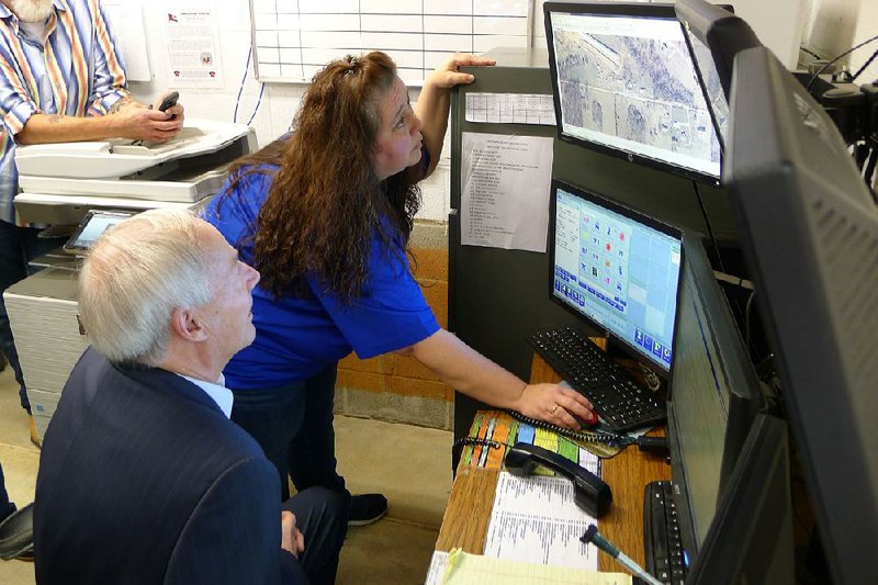
With the new digital maps, dispatchers will be able to tell emergency personnel to turn at a particular barn in rural areas, said Sgt. Lola Mitchell with the Madison County sheriff's office.
Mitchell, a dispatcher and jail administrator, showed Hutchinson some of the benefits of the maps on computers in the basement of the courthouse after the news conference.
In addition to showing roads and buildings, the images are the foundation for maps that pinpoint the location of water, power and gas lines, and administrative boundaries such as school districts or city boundaries, according to the news release.
That information can be layered on the Geographic Information Systems map.
At the Arkansas Department of Emergency Management, fire services coordinator Kendall Snyder said he's in the process of mapping the resources of every fire district and fire station to help with emergency response.
The map already notes every fire district and fire station, but when Snyder is done, it will note how many trucks and other resources each district and station has.
The state's Geographic Information Systems maps are also used in court, Johnson said. Attorneys have used them in vehicle accident reconstruction. Johnson recalled an instance in which a state map was used to show that acres of forest had been removed during a dispute over someone cutting down trees on another person's property.
The project's price has dropped every year because of advancements in technology and the more ubiquitous nature of it, Johnson said. The cost for the 2000-01 map done by the Geographic Information Office was $2.1 million. The cost dropped to $1.98 million in 2006.

Metro on 12/28/2017