The White River crested about a half-foot below expectations Tuesday evening in Des Arc and will drop more quickly than what National Weather Service meteorologists first forecast, giving emergency workers hope that levees will hold back floodwaters.
Officials repaired a handful of minor "boils" -- or water seeping through weakened areas of the levee -- near Des Arc on Tuesday, said Davis Bell, spokesman for Prairie County's Office of Emergency Management. There were no breaches and levees remained sturdy, he said.
"Everybody is breathing a sigh of relief," Bell said of the updated river forecast.
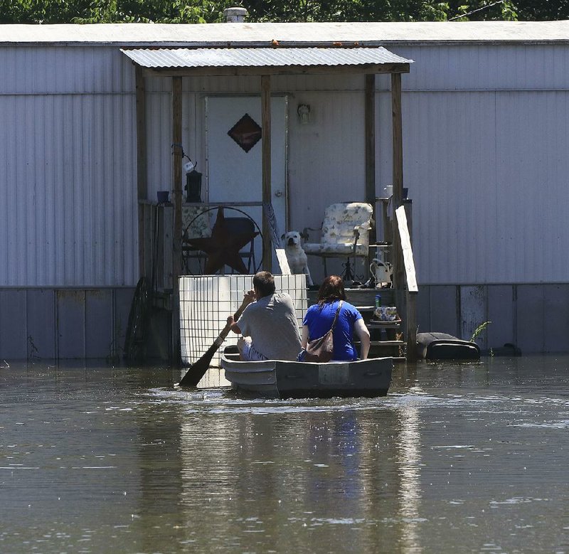
Still, homes along the river east of Des Arc and farther downstream in DeValls Bluff and Clarendon saw water rise, and the White River's crest won't reach Clarendon until Saturday.
"It's almost here," DeValls Bluff Mayor Kenny Anderson said of the White River's peak. "Flooding is in the normal areas. It's flooding where it's supposed to be.
"It'll reach 36 feet this time," he said. "It got to 39.7 feet in 2011. It won't be as bad as 2011, thank the Lord."
Emergency officials evacuated homes in Biscoe and in the Spring Lake community east of Des Arc because of rising waters.
The White River Dairy Bar on Arkansas 33 east of DeValls Bluff was closed Monday because of the high waters. Workers there surrounded the store with sandbags.
In Northwest Arkansas, officials with the Federal Emergency Management Agency prepared to begin surveying damage today, said Melody Daniel, a spokesman for the Arkansas Department of Emergency Management. Teams are also expected to begin assessing damage to homes in central Arkansas today.
"We've already got a handle on some of the hardest-hit areas," Daniel said.
She said county office of emergency management coordinators have given the state emergency department preliminary estimates of damage, but those numbers are constantly increasing as flood waters recede and more areas can be accessed.
"We'll have a better idea of the total as we go along with surveys," she said.
Storms blasted through the state April 29 and April 30, causing flash flooding, spawning several tornadoes and knocking out power to thousands of homes and businesses.
At least nine people died in the storms, emergency officials said.
Much of northern Arkansas received 4 to 6 inches of rain.
In southern Missouri, up to 10 inches of rain fell near Van Buren, Mo., and Doniphan, Mo., flowing into the Current River and causing it to flood at record levels. The "flood wave," or rise of floodwater, moved its way south down the river and into Arkansas where the Current River pours into the Black River near Pocahontas.
The Randolph County town saw a record level of 28.95 feet May 2 on the Black River, surpassing its previous high mark of 28.4 feet set April 28, 2011. A levee protecting east Pocahontas from the river broke in nine places after the Black River topped it.
More than 50 homes were destroyed by flooding and another 100 were damaged, said David Jansen, the county judge for Randolph County.
The river continued to recede in Pocahontas, measuring 23.1 feet Tuesday evening. Residents of the flooded east Pocahontas neighborhood tore out soaked carpeting and walls, piled flood-damaged furniture and appliances in front of their houses and cleaned debris from yards.
Jansen said he attended his granddaughter's softball game Tuesday afternoon near Pocahontas Municipal Airport on a field that was under 2 feet of water last week.
"It's getting better," he said. "Things are starting to dry out."
Water still prevented him from seeing damage to county roads in some spots, though.
"I know we have extensive damage in the bottoms," Jansen said, referring to low-lying areas in eastern Randolph County. "Our road foreman said he saw at least three miles of a road that had washed out and was gone.
"We're going to have a lot of work ahead of us."
Bell, the Prairie County Office of Emergency Management spokesman, said the White River's crest of 35.5 feet Tuesday in Des Arc, rather than the original forecast of 36 feet for today, means several homes will be spared from flooding.
"That one foot or so saved half of an area we were prepared to lose to the water," Bell said.
The White River is also forecast to recede quickly.
"We are cautiously excited," Bell said. "The faster the water goes, the less stress on our levee."
More rain is in the forecast for most of the state Thursday and Friday, said meteorologist Heather Cross of the National Weather Service in North Little Rock.
The eastern half of the state should see half an inch to 1 inch of rain as an upper level low heads into the state Thursday afternoon.
The western half of the state could receive an inch of rain, Cross said. There is also a chance for damaging winds and hail.
"The winds could be dangerous," Cross said. "Trees could easily topple down in the wind because their roots are already in saturated ground."
The rain won't cause the White River to rise again, but it could slow its drop, she said.
Storms are expected to move out of the state by early Friday evening, she said.
A Section on 05/10/2017