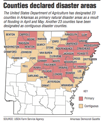
The U.S. Department of Agriculture declared 23 Arkansas counties disaster areas Friday after damaging floods in April and May.
The department also named 23 more counties as contiguous disaster areas, meaning they, too, are eligible for federal assistance because they abut counties with the most damage.
Along with the 46 Arkansas counties, eight Missouri counties and four Tennessee counties were deemed disaster areas.
The declarations are separate from the presidential disaster declaration, which Arkansas Gov. Asa Hutchinson has requested. Officials with the Federal Emergency Management Agency are still compiling disaster estimates that must be made before a federal declaration can be made, said J.R. Davis, a spokesman for the governor.
U.S. Secretary of Agriculture Sonny Perdue visited Arkansas earlier this month, flying over flooded areas along the Spring River and Black River in northeast Arkansas and the White River in central Arkansas.
'The secretary saw firsthand the damage our state suffered due to flooding, including the destruction of thousands of acres of farmland," Hutchinson said in a news release Friday. "The disaster declaration will give our farmers access to emergency loans that will help them get back on their feet after last month's devastating storms."
The counties that received disaster declarations include Boone, Carroll, Clay, Conway, Craighead, Faulkner, Greene, Independence, Jackson, Lawrence, Lonoke, Madison, Mississippi, Monroe, Newton, Perry, Poinsett, Prairie, Pulaski, Randolph, St. Francis, White and Woodruff.
Named as contiguous disaster counties are Arkansas, Benton, Cleburne, Crawford, Crittenden, Cross, Franklin, Garland, Grant, Izard, Jefferson, Johnson, Lee, Marion, Phillips, Pope, Saline, Searcy, Sharp, Stone, Van Buren, Washington and Yell.
More than 6 inches of rain fell across northern Arkansas on April 29 and April 30, causing flash flooding and knocking out power to thousands. Nine people died in the storms.
Up to 10 inches of rainfall poured into the Current River in southeastern Missouri, setting record highs for the river in St. Charles and Doniphan, Mo. That water poured into Arkansas' Black River in Randolph County, flooding the river and topping a levee system that protected east Pocahontas.
At least nine sections of the levee broke, sending a rush of water across farm fields between Pocahontas and Lawrence County before it returned to the Black River south of Clover Bend.
The glut of water made its way down the Black River before pouring into the White River near Jacksonport.
Earlier this month, the University of Arkansas System Division of Agriculture estimated crop flood damage at $64.5 million. Davis said he has not seen a new total for crop loss, but expects it to be higher once all areas can be assessed.
In Lawrence County, where water from the Black and Strawberry rivers remains in some low-lying farm fields, at least 83,000 of the county's 200,000 acres were damaged, extension agent Herb Ginn said.
"There are some fields that are covered in sand that was washed in during the flood," he said.
When water broke through the Black River levees near Pocahontas, the Running Water Ditch overflowed. Some spots were under 8 feet of water between Pocahontas and Walnut Ridge. The Arkansas Highway Department was forced to close U.S. 67 for about two weeks because of the high water over the roadway.
Greg Gill, a Lawrence County farmer who has land in the western and central parts of the county, said he lost nearly 1,000 acres of corn and peanut farmland. He said a 200-acre plot of land has "huge holes" that were washed out by rapid floodwater.
"Every farmer through here has had some damage," he said. "This will put some people out of business this time."
The area also saw flooding in 2008 and 2011, when sections of the Black River near Pocahontas broke.
"Things come in extremes," Ginn said. "Either we have flooding or we have drought. I don't know what a 'normal' year is anymore."
The National Weather Service is calling for more rain this evening and Sunday, with some storms having the potential to produce damaging winds, hail and rain.
Meteorologist Heather Cross of the National Weather Service in North Little Rock said most of the state will see about an inch of rain as an upper level low pressure system moves through Arkansas. The Storm Prediction Center in Norman, Okla., said northern Arkansas has a "moderate" risk -- the third-highest potential rating -- for winds, hail and tornadoes this evening.
Most of central Arkansas has a lesser, "enhanced" risk for storms, the center said.
Cross said any rain that falls this weekend won't affect flooding along the White River.
"It's not going to do a lot," she said. "It may slow the downfall slightly, but it won't cause anymore flooding. But any water is not welcome."
State Desk on 05/27/2017