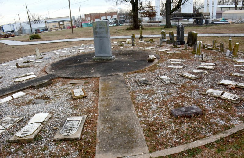
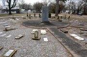
SILOAM SPRINGS -- A concrete trail slices through a cemetery that is the final resting place for city founders.
City leaders said they had no choice and did everything possible to preserve the site. Area historians said they're appalled a city would dishonor a sacred place with an 8-foot wide slab of concrete.
The trail that runs through the old cemetery is part of the city Sidewalk and Trail Master Plan.
"If only one person is upset about it, there's probably 300 to 400 people upset who you don't hear about," said Rick Parker, who has deep family roots in town and works on historical restoration on a local and international level. "I wouldn't want to go through my life and be OK with putting a hiking and biking trail over a cemetery. It's appalling and to say I'm disappointed is an understatement. It's just patently wrong."
It's not the first time the city has altered Hico Cemetery, which includes remains from the 1800s. Veterans of the Civil War and Mexican War as well as early city founders Simon Sager and John V. Hargrove are buried there.
Concerns over vandalism at the cemetery in 1976 resulted in the city removing some headstones. It created a memorial with a circular pattern of headstones facing a large dedication stone in the middle.
"The graves themselves are still buried in the yard around the renovated center where the stones sit," according to a story from John Brown University's Threefold Advocate newspaper in 2013.
The circular monument sits along the top of a cliff above downtown nestled into a curve in the road along Tahlequah Street. The street narrows around the corner, making visibility an issue for motorists and pedestrians. That is why city officials said they couldn't put the trail alongside the road and went through the cemetery grounds. A few unmarked foot stones from old graves are visible near the new path.
The trail along Tahlequah Street was ranked the fifth most urgent project on the master trail plan because of the number of pedestrians in the area.
Before the trail was built, people walked a similar path through the cemetery. It's not fenced or marked to indicate the open area near the monument, so pedestrians likely were unaware they were walking over graves.
"So what is government?" asked city administrator Phillip Patterson. "It's a balancing act of competing ideas, of competing goals, or competing issues. So, here we have protection of the cemetery, the need to give pedestrians access, so how do we balance those needs? How do we balance that?
"We think that's what we've done to the best of our ability."
City engineer Justin Bland said staff considered several routes for the trail. If it was put along the roadway like other parts of the master plan system, a significant amount of dirt work would have been required in addition to the safety issue, Bland said.
The cemetery route was chosen because it had the least impact, he said.
Siloam Springs senior planner Don Clark echoed Bland's opinion.
"If you look at Washington Street and Tahlequah in the morning, you have high traffic of kids walking to school, which is why this was such an important project," Clark said. "Now they have a path because there is no shoulder when coming around that roadway, it is very narrow. It's difficult to see and safety was a priority.
"If you remember three years ago, that place was flooded with people playing Pokeman Go. They probably had no idea that that was an actual cemetery."
Bland said city staff used a ground penetrating radar unit to locate graves. The radar transmits a high-frequency, electromagnetic energy signal to target the depth and location of items in the soil.
Historians argue many of the graves at Hico Cemetery are shallow because its on a rocky hill. In addition, many people buried were wrapped only in a blanket, so there would be no nails from the corner of a typical pine box casket to locate.
"This GPR unit does not need a burial vault to detect a grave and can detect shallow grave sites," Bland wrote in an email. "Using this information, staff was able to determine that the graves were on a certain grid system. A route was chosen through this grid to avoid all detected graves and minimize impact as much as possible.
"Furthermore, the trail section was modified such that just the grass was scraped off the existing ground. Typically, a trail section would be dug much deeper. Now that the grass has been scraped off, we can verify that no graves were disturbed and to the best of our knowledge, utilizing the techniques above, the trail doesn't cross over any graves."
Don Warden, Siloam Springs museum director, was concerned. City staff eased his mind with the radar unit.
"People will see the sidewalk, and people will be concerned that the graves were still out there," he said. "I'm not sure how many people know that, but you can see foundations where other headstones were out there and a few foot stones. I've always felt like the bodies were still out there, although a few graves were moved out to Oak Hill.
"The city made every attempt not to go over any graves. Not that they didn't go over any graves, but if they did, not that many. I have no way of knowing that for sure."
Glenn Jones, who recently stepped down after 10 years as head of the Benton County Historic Preservation Commission, said the trail should have gone elsewhere.
"This is totally disrespectful. You don't build over the top of them. I don't know how in good conscious that any city could say they think the graves are no longer there, so let's build a sidewalk over it," he said.
Jones said he's familiar with the use of ground-penetrating radar to identify grave sites.
"You can't prove what's under the ground with GPR," he said. "Especially in the Ozark soil, which is highly acidic, the only thing a GPR can identify is moved dirt."
NW News on 04/02/2018