9 P.M. UPDATE:
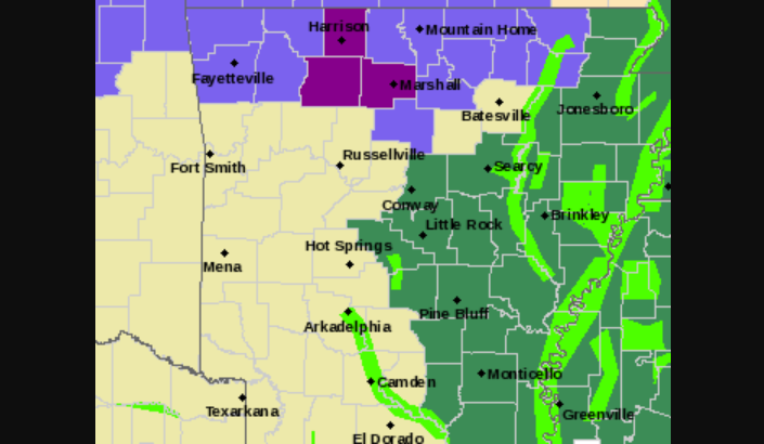
The National Weather Service bureau in North Little Rock issued an ice storm warning Tuesday night for three counties in north Arkansas. The weather service warned of the potential for "significant icing," much of it on trees and power lines in Boone, Newton and Searcy counties. The warning expires at midnight. The bureau said that the ice could cause tree limbs to break and result in power outages, and that there might be slick areas on bridges and overpasses.
Elsewhere in Arkansas, much of the north part of the state remained under a winter weather advisory, and the east portion was covered in a flash flood watch as rain continued to fall.
— Maggie McNeary
EARLIER:
Northwest Arkansas is under a winter weather advisory on Tuesday as much of the rest of the state braces for the possibility of heavy rainfall and flooding, forecasters said. Later in the week, severe weather is possible.
Residents in the northwest corner of the state may see a mix of sleet and light freezing rain late Tuesday morning and into the afternoon, according to Brian Smith, a senior forecaster at the National Weather Service in North Little Rock. A winter weather advisory is in effect for Benton, Washington, Carroll and Madison counties until 6 a.m. Wednesday.
According to forecasters, though bridges and overpasses may become slick, impacts from the winter weather in those counties are expected to be minor.
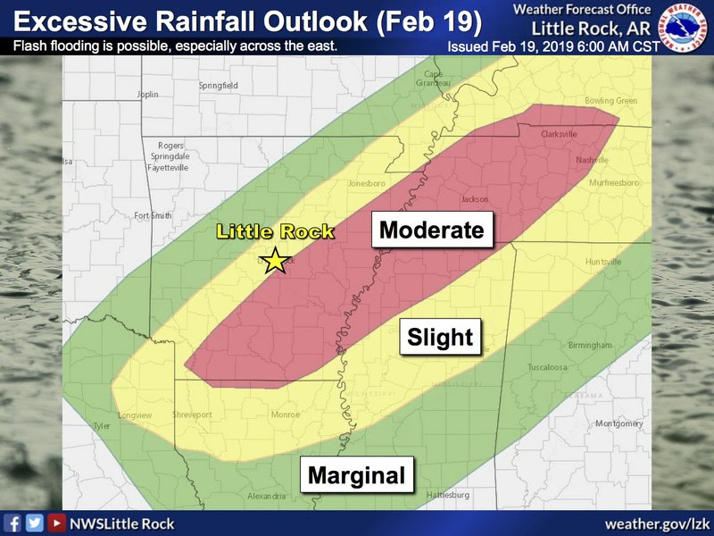
But the possibility of heavy rain has increased elsewhere in Arkansas. Even in areas southeast of those under the advisory, the precipitation may start as a mix of sleet and freezing rain before becoming a cold rain, forecasters said.

Much of the eastern half of the state is under a flash flood watch — including Jackson County, where heavy rains last week weakened a levee south of Newport and prompted flooding concerns. Flood warnings were in effect Tuesday for parts of the White, Cache, Black, Mississippi, Ouachita and St. Francis rivers.
The White River at Patterson is forecast to reach major flood stage on Thursday before cresting on Sunday. At those levels, residents can expect water near foundations of homes along Pine Street, as well as flooding at cabins and camps along Arkansas 14, Arkansas 18 and Arkansas 33. Most unprotected farmlands may become flooded and some levees overtopped.
The White River at Georgetown, Des Arc and Clarendon is expected to reach moderate flood levels through Saturday. At Clarendon, it's expected to peak Thursday at 30.5 feet, the weather service said.
The agency reported that “many acres of farmland” within the levees are expected to flood, with water backing up Bayou Des Arc and Cypress Bayou. Des Arc Mayor James B. Garth said his city should remain safe.
“The only thing we’re doing is watching the forecast and seeing what’s happening,” Garth said. “If the forecast holds true then we’re not in any danger.”
Severe weather will be possible Saturday afternoon and evening ahead of an approaching cold front, bringing a risk of strong to severe thunderstorms capable of producing large hail, Smith said. According to Smith, a risk of tornadoes developing also exists, though the greatest concern will be damaging winds.
